Melia, Nebraska
Melia | |
|---|---|
 West on Melia Road overlooking the Platte River, May 2017 | |
 Melia Location within the state of Nebraska  Melia Location within the United States | |
| Coordinates: 41°05′46″N 96°16′32″W / 41.09611°N 96.27556°W | |
| Country | United States |
| State | Nebraska |
| County | Sarpy |
| Area | |
• Total | 1.44 sq mi (3.73 km2) |
| • Land | 1.44 sq mi (3.73 km2) |
| • Water | 0.00 sq mi (0.00 km2) |
| Elevation | 1,132 ft (345 m) |
| Population (2020) | |
• Total | 98 |
| • Density | 68.06/sq mi (26.27/km2) |
| Time zone | UTC-6 (Central (CST)) |
| • Summer (DST) | UTC-5 (CDT) |
| ZIP codes | 68028 |
| FIPS code | 31-31605 |
| GNIS feature ID | 835379[2] |
Melia is a census-designated place (CDP) in Sarpy County, Nebraska, United States.[2]
Melia was named in honor of an early settler, John J. Melia. It was a station on the Chicago, Burlington, and Quincy Railroad.[3]
Demographics
| Census | Pop. | Note | %± |
|---|---|---|---|
| 2020 | 98 | — | |
| U.S. Decennial Census[4] | |||
See also
References
- ^ "ArcGIS REST Services Directory". United States Census Bureau. Retrieved September 18, 2022.
- ^ a b c U.S. Geological Survey Geographic Names Information System: Melia, Nebraska
- ^ Fitzpatrick, Lillian L. (1960). Nebraska Place-Names. University of Nebraska Press. p. 125. ISBN 0-8032-5060-6.
{{cite book}}: ISBN / Date incompatibility (help) A 1925 edition is available for download at University of Nebraska—Lincoln Digital Commons. - ^ "Census of Population and Housing". Census.gov. Retrieved June 4, 2016.
External links
![]() Media related to Melia, Nebraska at Wikimedia Commons
Media related to Melia, Nebraska at Wikimedia Commons
Municipalities and communities of Sarpy County, Nebraska, United States | ||
|---|---|---|
| Cities | 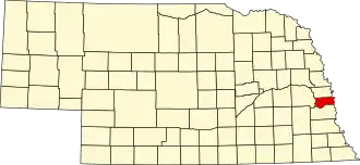 | |
| CDPs | ||
| Other communities | ||