Meall Odhar
| Meall Odhar | |
|---|---|
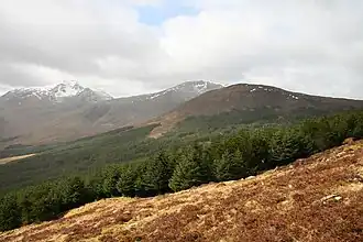 Meall Odhar is the forested hill on the right. | |
| Highest point | |
| Elevation | 656 m (2,152 ft)[1] |
| Prominence | 183 m (600 ft) |
| Listing | Graham, Marilyn |
| Geography | |
| Location | Stirling, Scotland |
| Parent range | Grampian Mountains |
| OS grid | NN29797289 |
| Topo map | OS Landranger 50 |
Meall Odhar is a mountain in the Scottish Highlands, situated about 3 km to the west of Tyndrum, close to the northern boundary of the Loch Lomond and the Trossachs National Park. Meall Odhar is part of the Tyndrum Hills. With a height of 656 m and a drop of 183 m, it is listed as a Marilyn and a Graham.[2] The name Meall Odhar is from the Gaelic for "dun-coloured round hill".
References
- ^ "Meall Odhar". hill-bagging.co.uk. Retrieved 14 May 2019.
- ^ Database of British and Irish Hills. Retrieved 21 Jan 2012.
56°25′48″N 4°45′39″W / 56.43000°N 4.76083°W