McMullin, Virginia
McMullin | |
|---|---|
 McMullin Location within the Commonwealth of Virginia | |
| Coordinates: 36°49′3″N 81°34′31″W / 36.81750°N 81.57528°W | |
| Country | United States |
| State | Virginia |
| County | Smyth |
| Population (2010) | |
• Total | 464 |
| Time zone | UTC−5 (Eastern (EST)) |
| • Summer (DST) | UTC−4 (EDT) |
| ZIP codes | 24354 |
| FIPS code | 51-48445 |
| GNIS feature ID | 2629841 |
McMullin is a census-designated place in Smyth County, Virginia, United States. The population as of the 2010 Census was 464.[1]
Fox Farm site was listed on the National Register of Historic Places in 1978.[2]
Demographics
| Census | Pop. | Note | %± |
|---|---|---|---|
| 2010 | 464 | — | |
| U.S. Decennial Census[3] 2010[4] 2020 | |||
McMullin was first listed as a census designated place in the 2010 U.S. Census.[4]
References
- ^ Virginia Trend Report 2: State and Complete Places (Sub-state 2010 Census Data). Missouri Census Data Center. Accessed 2011-06-08.
- ^ "National Register Information System". National Register of Historic Places. National Park Service. July 9, 2010.
- ^ "Decennial Census by Decade". United States Census Bureau.
- ^ a b "2010 Census of Population - Population and Housing Unit Counts - Virginia" (PDF). United States Census Bureau.
Municipalities and communities of Smyth County, Virginia, United States | ||
|---|---|---|
| Towns | 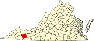 | |
| CDPs | ||
| Other communities | ||