Mavrata
Mavrata
Μαυράτα | |
|---|---|
 Mavrata | |
| Coordinates: 38°4.3′N 20°43.6′E / 38.0717°N 20.7267°E | |
| Country | Greece |
| Administrative region | Ionian Islands |
| Regional unit | Kefalonia |
| Municipality | Argostoli |
| Municipal unit | Eleios-Pronnoi |
| Population (2021)[1] | |
• Community | 120 |
| Time zone | UTC+2 (EET) |
| • Summer (DST) | UTC+3 (EEST) |
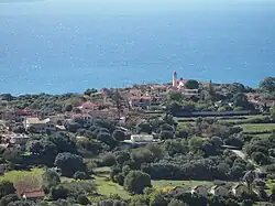
Mavrata (Greek: Μαυράτα) is a village in the municipal unit of Eleios-Pronnoi, in the southeastern part of the island of Cephalonia, Greece. In 2011 its population was 139. It is situated on a hill above the Ionian Sea coast, at about 180 m elevation. It is 1 km south of Chionata, 3 km southwest of Pastra and 10 km southwest of Poros. It was devastated by the 1953 Ionian earthquake.
Population
| Year | Population |
|---|---|
| 1981 | 143 |
| 1991 | 109 |
| 2001 | 159 |
| 2011 | 139 |
| 2021 | 120 |
See also
References
- ^ "Αποτελέσματα Απογραφής Πληθυσμού - Κατοικιών 2021, Μόνιμος Πληθυσμός κατά οικισμό" [Results of the 2021 Population - Housing Census, Permanent population by settlement] (in Greek). Hellenic Statistical Authority. 29 March 2024.