Marengo (CDP), Wisconsin
Marengo, Wisconsin | |
|---|---|
 Looking south at Marengo on WIS13 | |
 Marengo | |
| Coordinates: 46°25′21″N 90°49′01″W / 46.42250°N 90.81694°W | |
| Country | United States |
| State | Wisconsin |
| County | Ashland |
| Town | White River |
| Area | |
• Total | 1.024 sq mi (2.65 km2) |
| • Land | 1.024 sq mi (2.65 km2) |
| • Water | 0 sq mi (0 km2) |
| Elevation | 761 ft (232 m) |
| Population | |
• Total | 148 |
| • Density | 140/sq mi (56/km2) |
| Time zone | UTC-6 (Central (CST)) |
| • Summer (DST) | UTC-5 (CDT) |
| ZIP code | 54855[2] |
| Area codes | 715 & 534 |
| GNIS feature ID | 1569024[3] |
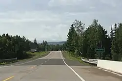
Marengo is an unincorporated census-designated place located in the town of White River, Ashland County, Wisconsin, United States. Marengo is located on Wisconsin Highway 13 10 miles (16 km) northwest of Mellen. Marengo had a post office, which closed on June 27, 2009.[4] At the 2020 census, its population was 148, up from 111 at the 2010 census.[5] Bus service to the community is provided by Bay Area Rural Transit.
References
- ^ "Census Bureau profile: Marengo CDP, Wisconsin". United States Census Bureau. May 2023. Retrieved October 29, 2024.
- ^ United States Postal Service (2012). "USPS - Look Up a ZIP Code". Retrieved February 15, 2012.
- ^ U.S. Geological Survey Geographic Names Information System: Marengo (CDP), Wisconsin
- ^ "Postmaster Finder - Post Offices by ZIP Code". United States Postal Service. Retrieved September 25, 2011.
- ^ "U.S. Census website". U.S. Census Bureau. Retrieved April 14, 2011.
Municipalities and communities of Ashland County, Wisconsin, United States | ||
|---|---|---|
| Cities | 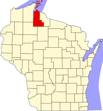 | |
| Village | ||
| Towns | ||
| CDPs | ||
| Other communities | ||
| Indian reservation | ||
| Footnotes | ‡This populated place also has portions in an adjacent county or counties | |