Mantong, Myanmar
Manton
မန်တုံ Mantong | |
|---|---|
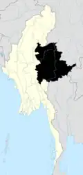
 Manton Location in Myanmar | |
| Coordinates: 23°15′02″N 97°07′17″E / 23.25056°N 97.12139°E | |
| Country | |
| State | |
| Self-administered zone | |
| Township | Mantong Township |
| Area | |
• Total | 0.8 sq mi (2 km2) |
| Population (2019)[1] | 3,565 |
| • Density | 4,620/sq mi (1,783/km2) |
| • Religions | Buddhism |
| Time zone | UTC+6.30 (MMT) |
Mantong (Burmese: မန်တုံမြို့)is the principal town of Mantong Township, one of the two townships in the Pa Laung Self-Administered Zone.
The town is 16 miles (26 km) from Bawdwin Mine in Namtu Township. The town is in a mountainous area and lies east of the Shweli River, close to the Kokang Self-Administered Zone.[2]
During the current Myanmar civil war in December 2023, the town was the last State Administration Council-controlled territory in the Pa Laung Self-Administered Zone to be captured by the Ta'ang National Liberation Army during Operation 1027.[2]
References
- ^ Myanmar Information Management Unit (September 2019). the Pa uments/TspProfiles_GAD_Manton_2019_MMR.pdf Manton Myone Daethasaingyarachatlatmya မန်တုံမြို့နယ် ဒေသဆိုင်ရာအချက်လက်များ [Mantong Township Regional Information] (PDF) (Report). MIMU. Retrieved 17 October 2023.
{{cite report}}: Check|url=value (help) - ^ a b Hein Htoo Zan (23 December 2023). "Brotherhood Alliance Seizes Another Ethnic Zone in Myanmar's northern Shan State". The Irrawaddy.