Saint-Paul-sur-Ubaye
Saint-Paul-sur-Ubaye | |
|---|---|
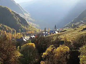 A view of the hamlet of Grande Serenne, in the commune of Saint-Paul-sur-Ubaye | |
Location of Saint-Paul-sur-Ubaye | |
 Saint-Paul-sur-Ubaye 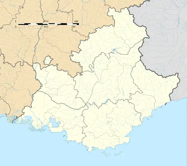 Saint-Paul-sur-Ubaye | |
| Coordinates: 44°30′57″N 6°45′08″E / 44.5158°N 6.7522°E | |
| Country | France |
| Region | Provence-Alpes-Côte d'Azur |
| Department | Alpes-de-Haute-Provence |
| Arrondissement | Barcelonnette |
| Canton | Barcelonnette |
| Intercommunality | Vallée de l'Ubaye - Serre-Ponçon |
| Government | |
| • Mayor (2020–2026) | Bernard Isoard[1] |
Area 1 | 205.55 km2 (79.36 sq mi) |
| Population (2022)[2] | 195 |
| • Density | 0.95/km2 (2.5/sq mi) |
| Time zone | UTC+01:00 (CET) |
| • Summer (DST) | UTC+02:00 (CEST) |
| INSEE/Postal code | 04193 /04530 |
| 1 French Land Register data, which excludes lakes, ponds, glaciers > 1 km2 (0.386 sq mi or 247 acres) and river estuaries. | |
Saint-Paul-sur-Ubaye (French pronunciation: [sɛ̃ pɔl syʁ ybaj], lit. "Saint Paul-on-Ubaye"; Vivaro-Alpine: Sant Pau d'Ubaia, before 1998: Saint-Paul)[3] is an alpine commune on the Italian border in the Alpes-de-Haute-Provence department in the Provence-Alpes-Côte d'Azur region in Southeastern France.
Geography
With an area of 205.55 km2 (79.36 sq mi), the commune of Saint-Paul-sur-Ubaye is the largest commune in the Alpes-de-Haute-Provence department by surface area. It is located in the department's northeastern part, on the departmental border with Hautes-Alpes. The source of the Ubaye is in the commune.[4]
Climate
St. Paul sur-Ubaye has a subarctic climate (Dfc)
| Climate data for St Paul (1981–2010 averages, 1978–2018 extremes): elevation 1908m | |||||||||||||
|---|---|---|---|---|---|---|---|---|---|---|---|---|---|
| Month | Jan | Feb | Mar | Apr | May | Jun | Jul | Aug | Sep | Oct | Nov | Dec | Year |
| Record high °C (°F) | 13.2 (55.8) |
14.6 (58.3) |
18.4 (65.1) |
22.6 (72.7) |
25.0 (77.0) |
27.2 (81.0) |
29.1 (84.4) |
30.0 (86.0) |
28.6 (83.5) |
24.8 (76.6) |
19.2 (66.6) |
11.9 (53.4) |
30.0 (86.0) |
| Mean daily maximum °C (°F) | 0.8 (33.4) |
2.8 (37.0) |
5.6 (42.1) |
7.8 (46.0) |
12.7 (54.9) |
17.1 (62.8) |
20.5 (68.9) |
20.1 (68.2) |
16.2 (61.2) |
11.6 (52.9) |
5.5 (41.9) |
0.8 (33.4) |
10.1 (50.2) |
| Daily mean °C (°F) | −4.1 (24.6) |
−3.1 (26.4) |
−0.1 (31.8) |
2.5 (36.5) |
6.9 (44.4) |
10.4 (50.7) |
13.2 (55.8) |
12.9 (55.2) |
9.5 (49.1) |
5.6 (42.1) |
0.5 (32.9) |
−3.5 (25.7) |
4.2 (39.6) |
| Mean daily minimum °C (°F) | −8.9 (16.0) |
−9.0 (15.8) |
−5.8 (21.6) |
−2.8 (27.0) |
1.1 (34.0) |
3.7 (38.7) |
5.8 (42.4) |
5.7 (42.3) |
2.8 (37.0) |
−0.3 (31.5) |
−4.4 (24.1) |
−7.7 (18.1) |
−1.6 (29.0) |
| Record low °C (°F) | −22.9 (−9.2) |
−23.0 (−9.4) |
−22.7 (−8.9) |
−14.7 (5.5) |
−11.6 (11.1) |
−5.1 (22.8) |
−2.3 (27.9) |
−2.0 (28.4) |
−6.7 (19.9) |
−13.0 (8.6) |
−20.2 (−4.4) |
−23.0 (−9.4) |
−23.0 (−9.4) |
| Average precipitation mm (inches) | 57.3 (2.26) |
45.1 (1.78) |
57.7 (2.27) |
83.0 (3.27) |
89.0 (3.50) |
93.3 (3.67) |
69.0 (2.72) |
75.4 (2.97) |
90.8 (3.57) |
111.0 (4.37) |
79.3 (3.12) |
72.0 (2.83) |
922.9 (36.33) |
| Source: Meteociel[5] | |||||||||||||
Demographics
| Year | Pop. | ±% p.a. |
|---|---|---|
| 1968 | 232 | — |
| 1975 | 221 | −0.69% |
| 1982 | 208 | −0.86% |
| 1990 | 198 | −0.61% |
| 1999 | 190 | −0.46% |
| 2009 | 229 | +1.88% |
| 2014 | 202 | −2.48% |
| 2020 | 177 | −2.18% |
| Source: INSEE[6] | ||
See also
References
- ^ "Répertoire national des élus: les maires" (in French). data.gouv.fr, Plateforme ouverte des données publiques françaises. 13 September 2022.
- ^ "Populations de référence 2022" (in French). The National Institute of Statistics and Economic Studies. 19 December 2024.
- ^ Décret du 30 novembre 1998 portant changement de nom de communes, Légifrance.
- ^ Sandre. "Fiche cours d'eau - L'Ubaye (X04-0400)".
- ^ "Normales et records pour St Paul (04)". Meteociel. Retrieved 3 March 2024.
- ^ Population en historique depuis 1968, INSEE
Wikimedia Commons has media related to Saint-Paul-sur-Ubaye.