Maitland, Pennsylvania
Maitland, Pennsylvania | |
|---|---|
 Maitland, Pennsylvania  Maitland, Pennsylvania | |
| Coordinates: 40°37′47″N 77°30′12″W / 40.62972°N 77.50333°W | |
| Country | United States |
| State | Pennsylvania |
| County | Mifflin |
| Area | |
• Total | 1.44 sq mi (3.73 km2) |
| • Land | 1.44 sq mi (3.73 km2) |
| • Water | 0.00 sq mi (0.01 km2) |
| Elevation | 712 ft (217 m) |
| Population | |
• Total | 323 |
| • Density | 224.46/sq mi (86.66/km2) |
| Time zone | UTC-5 (Eastern (EST)) |
| • Summer (DST) | UTC-4 (EDT) |
| FIPS code | 42-46728 |
| GNIS feature ID | 2584483 |
Maitland is a census-designated place[4] in Derry Township, Mifflin County, Pennsylvania, United States, just outside the borough of Lewistown. At the 2010 census, the population was 357.[5]
Demographics
| Census | Pop. | Note | %± |
|---|---|---|---|
| 2020 | 323 | — | |
| U.S. Decennial Census[6] | |||
References
- ^ "ArcGIS REST Services Directory". United States Census Bureau. Retrieved October 12, 2022.
- ^ "Maitland Census Designated Place". Geographic Names Information System. United States Geological Survey, United States Department of the Interior. Retrieved January 29, 2013.
- ^ "Census Population API". United States Census Bureau. Retrieved October 12, 2022.
- ^ "By Decade".
- ^ "U.S. Census website". United States Census Bureau. Retrieved May 14, 2011.
- ^ "Census of Population and Housing". Census.gov. Retrieved June 4, 2016.
Municipalities and communities of Mifflin County, Pennsylvania, United States | ||
|---|---|---|
| Boroughs | 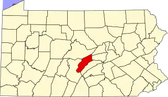 | |
| Townships | ||
| CDPs | ||
| Unincorporated communities | ||