Lurøya, Nordland
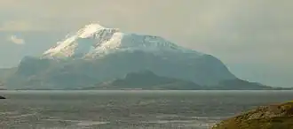 View of the mountain Lurøyfjellet on Lurøya | |
| Geography | |
|---|---|
| Location | Nordland, Norway |
| Coordinates | 66°25′07″N 12°52′44″E / 66.4187°N 12.8789°E |
| Area | 14.2 km2 (5.5 sq mi) |
| Length | 6 km (3.7 mi) |
| Width | 3.5 km (2.17 mi) |
| Highest elevation | 685 m (2247 ft) |
| Highest point | Lurøyfjellet |
| Administration | |
Norway | |
| County | Nordland |
| Municipality | Lurøy Municipality |
| Demographics | |
| Population | 138 (2017) |
| Pop. density | 9.7/km2 (25.1/sq mi) |
Lurøya[1] is an island in Lurøy Municipality in Nordland county, Norway. The 14.2-square-kilometre (5.5 sq mi) island is located just west of the island of Stigen and just north of the island of Onøya. Lurøya has a bridge connection to Onøya. The highest point on the island is the 685-metre (2,247 ft) tall mountain Lurøyfjellet. In 2017, there were 138 residents of the island.[2]
The village of Lurøy is located on the southwestern coast of Lurøya. Lurøy Church is located in the village of Lurøy.[2]
See also
References
- ^ "Informasjon om stadnamn". Norgeskart (in Norwegian). Kartverket. Retrieved 2024-10-01.
- ^ a b Thorsnæs, Geir, ed. (2017-07-14). "Lurøya". Store norske leksikon (in Norwegian). Kunnskapsforlaget. Retrieved 2019-02-02.