Listed buildings in Addington, Kent

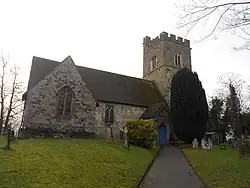
Addington is a village and civil parish in Kent, England. It contains 17 listed buildings that are recorded in the National Heritage List for England. Of these one grade I, one is grade II* and 15 are grade II.

This list is based on the information retrieved online from Historic England.[1][2][3]


Listing

NameGrade Location Type Completed [note 1]Date designated Grid ref.[note 2]
Geo-coordinates
Entry number [note 3]ImageWikidata
East Street Farmhouse
II
East Street 25 February 1987 TQ6600659181
51°18′27″N 0°22′49″E / 51.307537°N 0.38025472°E / 51.307537; 0.38025472 (East Street Farmhouse)
1070565
Upload Photo
Bumblebee Barn
II
East Street 14 August 1984 TQ6601659207
51°18′28″N 0°22′49″E / 51.307768°N 0.38041015°E / 51.307768; 0.38041015 (Bumblebee Barn)
1070564
Upload Photo
Old Cardicote White Cottage
II
East Street 25 February 1987 TQ6599059111
51°18′25″N 0°22′48″E / 51.306913°N 0.37999284°E / 51.306913; 0.37999284 (Old Cardicote White Cottage)
1070563
Upload Photo
Wall 40 Yards to the North East of Ford Place, That Part in Wrotham
II
Ford Lane 1 August 1952 TQ6366558625
51°18′12″N 0°20′47″E / 51.303220°N 0.34644467°E / 51.303220; 0.34644467 (Wall 40 Yards to the North East of Ford Place, That Part in Wrotham)
1236359
Upload Photo
Wall 10 Yards to the North East of Ford Place
II
Ford Lane 1 August 1952 TQ6367458600
51°18′11″N 0°20′48″E / 51.302993°N 0.34656220°E / 51.302993; 0.34656220 (Wall 10 Yards to the North East of Ford Place)
1236357
Upload Photo
Ford Place and Wall to North
II*
Ford Lane 1 August 1952 TQ6365058575
51°18′10″N 0°20′46″E / 51.302775°N 0.34620677°E / 51.302775; 0.34620677 (Ford Place and Wall to North)
1236317
Upload Photo
Church of St Margaret
I
Park Road 25 August 1959 TQ6538558879
51°18′18″N 0°22′16″E / 51.305005°N 0.37121373°E / 51.305005; 0.37121373 (Church of St Margaret)
1070567
Church of St Margaret
Q17530219
Chest Tomb 20 Yards to East of Addington Church
II
Park Road 25 February 1987 TQ6541158880
51°18′18″N 0°22′18″E / 51.305006°N 0.37158685°E / 51.305006; 0.37158685 (Chest Tomb 20 Yards to East of Addington Church)
1123708
Chest Tomb 20 Yards to East of Addington Church
Obelisk 20 Yards to East of Addington Church
II
Park Road 25 February 1987 TQ6541158877
51°18′18″N 0°22′18″E / 51.304979°N 0.37158546°E / 51.304979; 0.37158546 (Obelisk 20 Yards to East of Addington Church)
1363080
Upload Photo
Hedgehogs
II
St Vincent's Lane 25 February 1987 TQ6414458658
51°18′12″N 0°21′12″E / 51.303378°N 0.35332504°E / 51.303378; 0.35332504 (Hedgehogs)
1070568
Upload Photo
Westfield Farmhouse
II
St Vincent's Lane 23 September 1985 TQ6447358942
51°18′21″N 0°21′29″E / 51.305835°N 0.35817120°E / 51.305835; 0.35817120 (Westfield Farmhouse)
1337464
Upload Photo
St Vincent's
II
St Vincent's Lane 1 August 1952 TQ6426958576
51°18′09″N 0°21′18″E / 51.302606°N 0.35507887°E / 51.302606; 0.35507887 (St Vincent's)
1337427
Upload Photo
Stables to the north east of the Angel Inn
II
The Green 7 August 1978 TQ6560959069
51°18′24″N 0°22′28″E / 51.306647°N 0.37451238°E / 51.306647; 0.37451238 (Stables to the north east of the Angel Inn)
1070566
Upload Photo
Woodgate Cottages
II
Woodgate Road 25 February 1987 TQ6574359622
51°18′42″N 0°22′36″E / 51.311576°N 0.37668978°E / 51.311576; 0.37668978 (Woodgate Cottages)
1110844
Upload Photo
Woodgate Farmhouse
II
Woodgate Road 25 February 1987 TQ6555859628
51°18′42″N 0°22′27″E / 51.311684°N 0.37404063°E / 51.311684; 0.37404063 (Woodgate Farmhouse)
1363081
Upload Photo
The Angel Inn
II
The Green 7 August 1978 TQ6560159057
51°18′24″N 0°22′28″E / 51.306541°N 0.37439215°E / 51.306541; 0.37439215 (The Angel Inn)
1363078
Upload Photo
1 and 2 The Laurels
II
1 and 2 The Laurels 5 August 1977 TQ6561259114
51°18′25″N 0°22′28″E / 51.307050°N 0.37457625°E / 51.307050; 0.37457625 (1 and 2 The Laurels)
1123702
Upload Photo

See also

Notes

  1. ^ The date given is the date used by Historic England as significant for the initial building or that of an important part in the structure's description.
  2. ^ Sometimes known as OSGB36, the grid reference is based on the British national grid reference system used by the Ordnance Survey.
  3. ^ The "List Entry Number" is a unique number assigned to each listed building and scheduled monument by Historic England.

References