| Name
|
Address
|
Coordinates
|
Government recognition (CRHP №)
|

|
Image
|
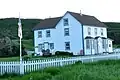
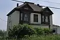
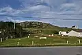
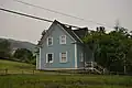
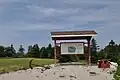
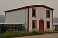
| Adams Home
|
Cape Onion NL
|
51°36′36″N 55°37′31″W / 51.61°N 55.6254°W / 51.61; -55.6254 (Adams Home, Cape Onion)
|
Newfoundland and Labrador (1895)
|
|
|
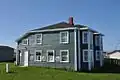
| Bank of Montreal
|
322 Curling Street
Corner Brook NL
|
48°57′30″N 57°59′41″W / 48.9582°N 57.9948°W / 48.9582; -57.9948 (Bank of Montreal)
|
Newfoundland and Labrador (2340)
|
|

Upload Photo
|
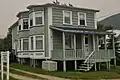
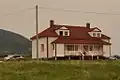
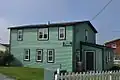
| Nurse Myra Bennett House Registered Heritage Structure
|
Daniel's Harbour NL
|
50°14′00″N 57°35′00″W / 50.2333°N 57.5833°W / 50.2333; -57.5833 (Nurse Myra Bennett House Registered Heritage Structure)
|
Newfoundland and Labrador (2186)
|
|
|
| Blanchard House
|
Woody Point NL
|
49°30′17″N 57°54′54″W / 49.5046°N 57.9149°W / 49.5046; -57.9149 (Blanchard House, Woody Point)
|
Newfoundland and Labrador (19590),
Woody Point municipality (4036)
|
|
|
| Bond Store
|
Woody Point NL
|
49°30′17″N 57°54′47″W / 49.5047°N 57.913°W / 49.5047; -57.913 (Bond Store, Woody Point)
|
Woody Point municipality (4048)
|
|
|
| Bonne Bay Cottage Hospital Municipal Heritage Building
|
Norris Point NL
|
49°32′18″N 57°52′57″W / 49.5382°N 57.8824°W / 49.5382; -57.8824 (Bonne Bay Cottage Hospital Municipal Heritage Building)
|
Norris Point municipality (5262)
|
|

|
| Walter F. Butt House
|
Woody Point NL
|
49°30′07″N 57°54′58″W / 49.502°N 57.9162°W / 49.502; -57.9162 (Walter F. Butt House, Woody Point)
|
Woody Point municipality (4050)
|
|
|
| John William Caines House Registered Heritage Structure
|
Norris Point NL
|
49°31′06″N 57°52′39″W / 49.5182°N 57.8776°W / 49.5182; -57.8776 (John William Caines House Registered Heritage Structure)
|
Newfoundland and Labrador (18906)
|
|
Upload Photo
|
| Casey Store
|
Conche NL
|
50°53′39″N 55°53′53″W / 50.8942°N 55.8981°W / 50.8942; -55.8981 (Casey Store, Conche)
|
Newfoundland and Labrador (2034),
Conche municipality (11947)
|
|
Upload Photo
|
| Captain Coubelongue Grave Site Municipal Heritage Site
|
Conche NL
|
50°54′08″N 55°53′19″W / 50.9021°N 55.8885°W / 50.9021; -55.8885 (Captain Coubelongue Grave Site Municipal Heritage Site, Conche)
|
Conche municipality (11945)
|
|
Upload Photo
|
| Cape Anguille Lightkeeper's Residence
|
Codroy NL
|
47°54′00″N 59°24′39″W / 47.9°N 59.4107°W / 47.9; -59.4107 (Cape Anguille Lightkeeper's Residence)
|
Newfoundland and Labrador (2090)
|
|
|
| Cape Anguille Light Tower
|
Codroy NL
|
47°53′54″N 59°24′39″W / 47.8983°N 59.4108°W / 47.8983; -59.4108 (Cape Anguille Light Tower)
|
Federal (13089, (20853)
|
|
|
| Cape Bauld Light Tower
|
Quirpon Island NL
|
51°38′21″N 55°25′42″W / 51.6391°N 55.4282°W / 51.6391; -55.4282 (Cape Bauld Light Tower)
|
Federal (13014)
|
|
Upload Photo
|
| 067 Central Street
|
67 Central Street
Corner Brook NL
|
48°57′05″N 57°55′58″W / 48.9513°N 57.9328°W / 48.9513; -57.9328 (67 Central Street)
|
Newfoundland and Labrador (2341)
|
|
|
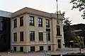
| Corner Brook Public Building
|
Corner Brook NL
|
48°57′10″N 57°56′41″W / 48.9529°N 57.9448°W / 48.9529; -57.9448 (Corner Brook Public Building)
|
Newfoundland and Labrador (2342)
|
|
|
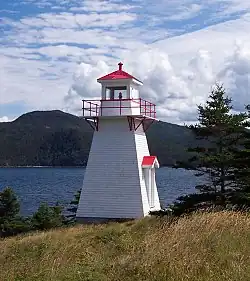
| Cow Head Light
|
Cow Head NL
|
49°55′11″N 57°48′49″W / 49.9198°N 57.8137°W / 49.9198; -57.8137 (Cow Head Light)
|
Cow Head municipality (3840)
|
|
|
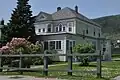
| George and Jane Crocker House
|
Woody Point NL
|
49°30′02″N 57°54′50″W / 49.5005°N 57.9139°W / 49.5005; -57.9139 (George and Jane Crocker House, Woody Point)
|
Woody Point municipality (4040)
|
|
|
| Jacob A. Crocker House
|
Trout River NL
|
49°28′51″N 58°07′40″W / 49.4809°N 58.1277°W / 49.4809; -58.1277 (Jacob A. Crocker House)
|
Newfoundland and Labrador (2176)
|
|
|
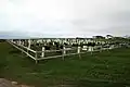
| East Side Interdenominational Cemetery Municipal Heritage Site
|
St. Anthony NL
|
51°21′50″N 55°34′08″W / 51.364°N 55.569°W / 51.364; -55.569 (East Side Interdenominational Cemetery Municipal Heritage Site)
|
St. Anthony municipality (10191)
|
|
|
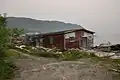
| Stanley Ford Home and Outbuildings Municipal Heritage Site
|
Jackson's Arm NL
|
49°51′56″N 56°47′45″W / 49.8656°N 56.7957°W / 49.8656; -56.7957 (Stanley Ford Home and Outbuildings Municipal Heritage Site)
|
Jackson's Arm municipality (5381)
|
|
Upload Photo
|
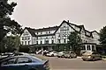
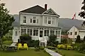
| Glynmill Inn Registered Heritage Structure
|
Corner Brook NL
|
48°56′56″N 57°56′23″W / 48.9488°N 57.9398°W / 48.9488; -57.9398 (Glynmill Inn Registered Heritage Structure, Corner Brook)
|
Newfoundland and Labrador (8579)
|
|
|
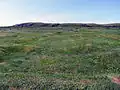
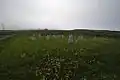
| Gravesite of Cow Head's First Settlers
|
Cow Head NL
|
49°55′21″N 57°48′29″W / 49.9224°N 57.8081°W / 49.9224; -57.8081 (Gravesite of Cow Head's First Settlers)
|
Cow Head municipality (4033)
|
|
Upload Photo
|
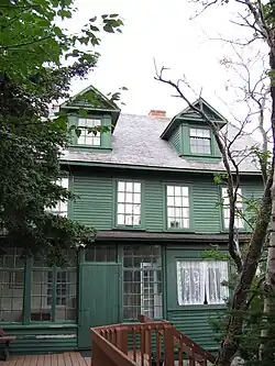
| Grenfell House
|
St. Anthony NL
|
51°22′00″N 55°35′00″W / 51.3667°N 55.5833°W / 51.3667; -55.5833 (Grenfell House, St. Anthony)
|
Newfoundland and Labrador (2324)
|
|
|
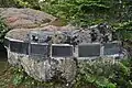
| The Grenfell Plaques Municipal Heritage Site
|
on the grounds of the Grenfell House Museum
St. Anthony NL
|
51°21′59″N 55°35′00″W / 51.3665°N 55.5833°W / 51.3665; -55.5833 (The Grenfell Plaques Municipal Heritage Site)
|
St. Anthony municipality (10171)
|
|
|
| Haliburton House
|
53 Water Street
Woody Point NL
|
49°30′13″N 57°54′46″W / 49.5036°N 57.9129°W / 49.5036; -57.9129 (Haliburton House, Woody Point)
|
Woody Point municipality (4049)
|
|
Upload Photo
|
| Hezikiah House
|
Woody Point NL
|
49°30′02″N 57°55′09″W / 49.5006°N 57.9191°W / 49.5006; -57.9191 (Hezikiah House, Woody Point)
|
Newfoundland and Labrador (2300)
|
|
|
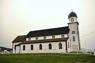
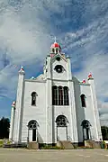
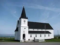
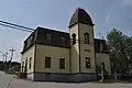
| Holy Trinity Anglican Church Registered Heritage Structure
|
Codroy NL
|
47°51′19″N 59°16′13″W / 47.8552°N 59.2703°W / 47.8552; -59.2703 (Holy Trinity Anglican Church Registered Heritage Structure, Codroy)
|
Newfoundland and Labrador (1947)
|
|
|
| Hulan House
|
Jeffrey's NL
|
48°14′00″N 58°50′42″W / 48.2333°N 58.845°W / 48.2333; -58.845 (Hulan House, Jeffrey's)
|
Newfoundland and Labrador (2091)
|
|
Upload Photo
|
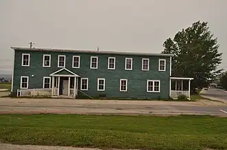
| International Pulp and Paper Company Staff House
|
Deer Lake NL
|
49°10′14″N 57°25′57″W / 49.1705°N 57.4325°W / 49.1705; -57.4325 (International Pulp and Paper Company Staff House, Deer Lake)
|
Newfoundland and Labrador (2181)
|
|
|
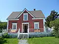
| Jenniex House Municipal Heritage Building
|
Norris Point NL
|
49°31′28″N 57°53′06″W / 49.5244°N 57.8849°W / 49.5244; -57.8849 (Jenniex House Municipal Heritage Building, Norris Point)
|
Norris Point municipality (8142)
|
|
|
| Keeper's Dwelling
|
Belle Isle NL
|
51°52′58″N 55°23′10″W / 51.8828°N 55.3861°W / 51.8828; -55.3861 (Keeper's Dwelling, Belle Isle)
|
Federal (3629)
|
|
Upload Photo
|
| L'Anse aux Meadows National Historic Site of Canada
|
11 km north of Saint-Luniare
St. Anthony NL
|
51°35′54″N 55°33′42″W / 51.5984°N 55.5618°W / 51.5984; -55.5618 (L'Anse aux Meadows National Historic Site of Canada)
|
Federal (4219)
|
|
|
| Lighttower
|
Belle Isle
Belle Isle NL
|
51°52′59″N 55°23′04″W / 51.8830°N 55.3845°W / 51.8830; -55.3845 (Lighttower (Belle Isle 1905 Light))
|
Federal (3904)
|
|
Upload Photo
|
| New Férolle Peninsula Lighthouse
|
Ferolle Point
New Ferolle NL
|
51°01′14″N 57°05′37″W / 51.0206°N 57.0936°W / 51.0206; -57.0936 (New Ferolle Peninsula Lighthouse)
|
Federal (3619, (20800)
|
|
|
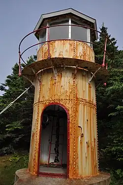
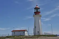
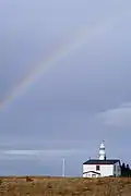
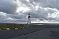
| Lobster Cove Head Lighthouse
|
Main Street North
Rocky Point NL
|
49°36′10″N 57°57′20″W / 49.6029°N 57.9556°W / 49.6029; -57.9556 (Lobster Cove Head Lighthouse)
|
Federal (4813)
|
|
More images
|
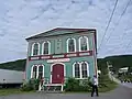
| Lord Nelson Loyal Orange Lodge LOL #149
|
Woody Point, Bonne Bay NL
|
49°30′10″N 57°55′03″W / 49.5028°N 57.9176°W / 49.5028; -57.9176 (Lord Nelson Loyal Orange Lodge LOL #149, Woody Point)
|
Newfoundland and Labrador (2177)
|
|
|
| Belle Isle South End Lower Lighthouse
|
Belle Isle NL
|
51°52′58″N 55°23′10″W / 51.8828°N 55.3861°W / 51.8828; -55.3861 (Belle Isle South End Lower Lighthouse)
|
Federal (3628, (21136)
|
|
Upload Photo
|
| Lourdes Land Settlement Site Municipal Heritage Site
|
Lourdes NL
|
48°38′54″N 58°59′50″W / 48.6483°N 58.9971°W / 48.6483; -58.9971 (Lourdes Land Settlement Site Municipal Heritage Site)
|
Lourdes municipality (8009)
|
|
|
| Martinique Bay Provincial Historic Site
|
Conche NL
|
50°54′03″N 55°53′59″W / 50.9008°N 55.8997°W / 50.9008; -55.8997 (Martinique Bay Provincial Historic Site, Conche)
|
Newfoundland and Labrador (3083)
|
|
Upload Photo
|
| Arnold Morris House
|
St. George's NL
|
48°26′00″N 58°28′49″W / 48.4333°N 58.4803°W / 48.4333; -58.4803 (Arnold Morris House, St. George's)
|
Newfoundland and Labrador (2281)
|
|
Upload Photo
|
| Old Anglican Cemetery Municipal Heritage Site
|
Anchor Point NL
|
51°14′05″N 56°47′58″W / 51.2348°N 56.7994°W / 51.2348; -56.7994 (Old Anglican Cemetery Municipal Heritage Site, Anchor Point)
|
Anchor Point municipality (8060)
|
|
More images
|
| Old Anglican Cemetery Municipal Heritage Site
|
St. Paul's NL
|
49°51′26″N 57°49′11″W / 49.8571°N 57.8197°W / 49.8571; -57.8197 (Old Anglican Cemetery Municipal Heritage Site, St. Pauls)
|
St. Paul's municipality (12917)
|
|
Upload Photo
|
| Old Anglican Cemetery
|
Cow Head NL
|
49°55′16″N 57°48′24″W / 49.9212°N 57.8066°W / 49.9212; -57.8066 (Old Anglican Cemetery, Cow Head)
|
Cow Head municipality (4034)
|
|
|
| Old Church of England Cemetery Municipal Heritage Site
|
023C North Street, northwest of the Roman Catholic Church
Parson's Pond NL
|
50°02′08″N 57°42′27″W / 50.0355°N 57.7076°W / 50.0355; -57.7076 (Old Church of England Cemetery Municipal Heritage Site)
|
Parson's Pond municipality (8333)
|
|
Upload Photo
|
| Old Anglican Cemetery
|
14 Shore Road
Woody Point NL
|
49°30′00″N 57°54′59″W / 49.5000°N 57.9165°W / 49.5000; -57.9165 (Old Anglican Cemetery (Woody Point))
|
Woody Point municipality (4035)
|
|
Upload Photo
|
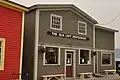
| Old Loft Restaurant/Jersey Room Crafts
|
Woody Point NL
|
49°30′02″N 57°54′49″W / 49.5006°N 57.9136°W / 49.5006; -57.9136 (Old Loft Restaurant/Jersey Room Crafts, Woody Point)
|
Woody Point municipality (4032)
|
|
|
| Old Roman Catholic Cemetery Municipal Heritage Site
|
St. Pauls NL
|
49°51′24″N 57°49′10″W / 49.8568°N 57.8195°W / 49.8568; -57.8195 (Old Roman Catholic Cemetery Municipal Heritage Site, St. Pauls)
|
St. Pauls municipality (12920)
|
|
Upload Photo
|
| William and Cecilia O'Neill Property
|
Conche NL
|
50°53′36″N 55°53′55″W / 50.8934°N 55.8985°W / 50.8934; -55.8985 (William and Cecilia O'Neill Property, Conche)
|
Newfoundland and Labrador (2183),
Conche municipality (11946)
|
|
Upload Photo
|
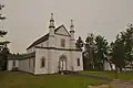
| Our Lady of Mercy Church Registered Heritage Structure
|
Port au Port NL
|
48°33′00″N 58°46′00″W / 48.55°N 58.7667°W / 48.55; -58.7667 (Our Lady of Mercy Church Registered Heritage Structure, Port au Port)
|
Newfoundland and Labrador (2280)
|
|
|
| Dr. Henry N. Payne Community Museum
|
Cow Head NL
|
49°54′47″N 57°47′41″W / 49.913°N 57.7948°W / 49.913; -57.7948 (Dr. Henry N. Payne Community Museum, Cow Head)
|
Cow Head municipality (3841)
|
|
|
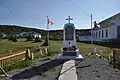
| 1942 Plane Crash Municipal Heritage Site
|
Conche NL
|
50°52′58″N 55°53′35″W / 50.8828°N 55.8931°W / 50.8828; -55.8931 (1942 Plane Crash Municipal Heritage Site, Conche)
|
Conche municipality (11949)
|
|
Upload Photo
|
| Port au Choix National Historic Site of Canada
|
Port au Choix NL
|
50°42′32″N 57°22′47″W / 50.7088°N 57.3796°W / 50.7088; -57.3796 (Port au Choix National Historic Site of Canada)
|
Federal (11464)
|
|

|
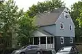
| Prebble House
|
Woody Point NL
|
49°30′07″N 57°54′49″W / 49.502°N 57.9137°W / 49.502; -57.9137 (Prebble House, Woody Point)
|
Woody Point municipality (4051)
|
|
|
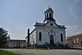
| Precious Blood Church and Bell House
|
St. Andrew's NL
|
47°46′35″N 59°16′48″W / 47.7764°N 59.28°W / 47.7764; -59.28 (Precious Blood Church and Bell House, St. Andrew's)
|
Newfoundland and Labrador (2238)
|
|
|
| William Henry Pynn House
|
Quirpon NL
|
51°34′49″N 55°26′00″W / 51.5803°N 55.4333°W / 51.5803; -55.4333 (William Henry Pynn House)
|
Newfoundland and Labrador (2094)
|
|
Upload Photo
|
| The Quidnock Municipal Heritage Site
|
Conche NL
|
50°53′01″N 55°53′48″W / 50.8835°N 55.8968°W / 50.8835; -55.8968 (The Quidnock Municipal Heritage Site, Conche)
|
Conche municipality (11948)
|
|
Upload Photo
|
| Quirpon Island Lightkeeper's Residence
|
Cape Bauld NL
|
51°38′24″N 55°25′40″W / 51.64°N 55.4278°W / 51.64; -55.4278 (Quirpon Island Lightkeeper's Residence)
|
Newfoundland and Labrador (3182)
|
|
Upload Photo
|
| Roberts Store
|
Woody Point NL
|
49°30′11″N 57°54′47″W / 49.5031°N 57.913°W / 49.5031; -57.913 (Roberts Store)
|
Woody Point municipality (4037)
|
|
|
| Edward J. Roberts House
|
Woody Point NL
|
49°30′09″N 57°54′48″W / 49.5025°N 57.9133°W / 49.5025; -57.9133 (Edward J. Roberts House)
|
Woody Point municipality (4052)
|
|
|
| John William Roberts House
|
Woody Point NL
|
49°30′12″N 57°54′51″W / 49.5033°N 57.9142°W / 49.5033; -57.9142 (John William Roberts House)
|
Newfoundland and Labrador (2190)
|
|
|
| St. Barnabas Anglican Church
|
Flower's Cove NL
|
51°17′48″N 56°44′01″W / 51.2968°N 56.7336°W / 51.2968; -56.7336 (St. Barnabas Anglican Church)
|
Newfoundland and Labrador (2105)
|
|
|
| St. George's Courthouse Registered Heritage Structure
|
St. George's NL
|
48°26′00″N 58°28′49″W / 48.4333°N 58.4803°W / 48.4333; -58.4803 (St. George's Courthouse Registered Heritage Structure)
|
Newfoundland and Labrador (2111)
|
|
|
| St. Joseph's Roman Catholic Church
|
St. George's NL
|
48°26′00″N 58°28′49″W / 48.4334°N 58.4803°W / 48.4334; -58.4803 (St. Joseph's Roman Catholic Church, St. George's)
|
Newfoundland and Labrador (2241)
|
|
|
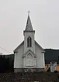
| St. Patrick's Church
|
Woody Point, Bonne Bay NL
|
49°29′59″N 57°55′13″W / 49.4998°N 57.9202°W / 49.4998; -57.9202 (St. Patrick's Church, Woody Point)
|
Newfoundland and Labrador (2180)
|
|
|
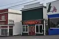
| Julius Swirsky Clothing Store Registered Heritage Structure
|
Corner Brook NL
|
48°57′06″N 57°57′05″W / 48.9516°N 57.9515°W / 48.9516; -57.9515 (Julius Swirsky Clothing Store Registered Heritage Structure)
|
Newfoundland and Labrador (10843)
|
|
|
| Tower
|
Port au Choix NL
|
50°41′53″N 57°24′39″W / 50.6981°N 57.4109°W / 50.6981; -57.4109 (Tower (Port au Choix/Point Riche Light))
|
Federal (9731)
|
|
|
| Upper Light Recognized Federal Heritage Building
|
Belle Isle NL
|
51°52′58″N 55°23′10″W / 51.8828°N 55.3861°W / 51.8828; -55.3861 (Upper Light (Belle Isle 1857 Light))
|
Federal (3905)
|
|
Upload Photo
|
| War Memorial Municipal Heritage Structure
|
St. Anthony NL
|
51°21′39″N 55°34′54″W / 51.3607°N 55.5818°W / 51.3607; -55.5818 (War Memorial Municipal Heritage Structure, St. Anthony)
|
St. Anthony municipality (8334)
|
|
|
| Wicks Store Municipal Heritage Site
|
Jackson's Arm NL
|
49°51′54″N 56°46′23″W / 49.865°N 56.773°W / 49.865; -56.773 (Wicks Store Municipal Heritage Site)
|
Jackson's Arm municipality (5870)
|
|
Upload Photo
|
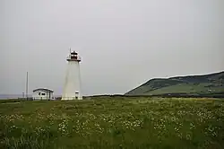
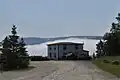
| Woody Point Lighthouse
|
Water Street
Woody Point NL
|
49°51′54″N 56°46′23″W / 49.865°N 56.773°W / 49.865; -56.773 (Woody Point Lighthouse)
|
Federal (21115)
|
|
|