| Name
|
Address
|
Coordinates
|
Government recognition (CRHP №)
|

|
Image
|
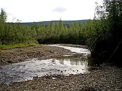
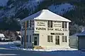
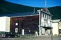
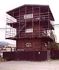
| Discovery Claim (Claim 37903) National Historic Site
|
Claim No. 37903
Bonanza Creek YT
|
63°55′00″N 139°19′01″W / 63.9168°N 139.317°W / 63.9168; -139.317 (Discovery Claim (Claim 37903) National Historic Site)
|
Federal (6310)
|
Q20725626
|
More images
|
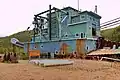
| Dredge No. 4 National Historic Site
|
Lot 586, group 1052
Bonanza Creek YT
|
63°56′38″N 139°20′10″W / 63.9439°N 139.336°W / 63.9439; -139.336 (Dredge No. 4 National Historic Site)
|
Federal (6280)
|
Q22975473
|
More images
|
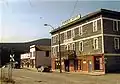
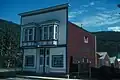
| Caribou Hotel
|
Dawson Charlie Street
Carcross YT
|
60°09′55″N 134°42′22″W / 60.1652°N 134.706°W / 60.1652; -134.706 (Caribou Hotel)
|
Yukon (9834)
|
Q132816820
|
More images
|
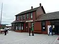
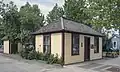
| White Pass and Yukon Railway Station
|
Main Street
Carcross YT
|
60°09′54″N 134°42′18″W / 60.165°N 134.705°W / 60.165; -134.705 (White Pass and Yukon Railway Station)
|
Federal (6723)
|
Q5038179
|
More images
|
| St. Paul's Anglican Church National Historic Site
|
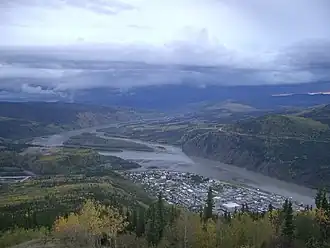
Dawson City YT
|
64°03′33″N 139°26′20″W / 64.0591°N 139.439°W / 64.0591; -139.439 (St. Paul's Anglican Church (Dawson City, Yukon)St. Paul's Anglican Church National Historic Site)
|
Federal (14122)
|
Q7591019
|
.JPG)
More images
|
| S.S. Keno National Historic Site
|
Dawson City YT
|
64°03′45″N 139°26′10″W / 64.0625°N 139.436°W / 64.0625; -139.436 (S.S. Keno National Historic Site)
|
Federal (9308)
|
Q7393921
|
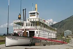
More images
|
| Lowe's Mortuary
|
Dawson City YT
|
64°03′45″N 139°25′55″W / 64.0626°N 139.432°W / 64.0626; -139.432 (Lowe’s Mortuary)
|
Federal (9692)
|
Q61499682
|
More images
|
| Bank of British North America
|
Queen Street
Dawson City YT
|
64°03′44″N 139°26′02″W / 64.0623°N 139.4339°W / 64.0623; -139.4339 (Bank of British North America)
|
Federal (11263)
|
Q61499699
|
More images
|
| BYN Ticket Office
|
Dawson City YT
|
64°03′49″N 139°26′02″W / 64.0636°N 139.434°W / 64.0636; -139.434 (BYN Ticket Office)
|
Federal (9704)
|
Q61499674
|
More images
|
| Canadian Bank of Commerce National Historic Site of Canada
|
Front and Queen Streets
Dawson City YT
|
64°03′46″N 139°26′07″W / 64.0628°N 139.4352°W / 64.0628; -139.4352 (Canadian Bank of Commerce National Historic Site of Canada)
|
Federal (15524)
|
Q22975460
|
.jpg)
More images
|
| KTM Building
|
Dawson City YT
|
64°03′40″N 139°25′56″W / 64.0612°N 139.4322°W / 64.0612; -139.4322 (KTM Building)
|
Federal (11425)
|
Q61499659
|

Upload Photo
|
| NWMP Married Quarters
|
Dawson City YT
|
64°03′25″N 139°26′17″W / 64.057°N 139.438°W / 64.057; -139.438 (NWMP Married Quarters)
|
Federal (9824)
|
Q61499693
|
Upload Photo
|
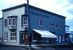
| Mme. Tremblay’s Store (16)
|
Dawson City YT
|
64°03′46″N 139°25′44″W / 64.0628°N 139.429°W / 64.0628; -139.429 (Mme. Tremblay’s Store (16))
|
Federal (9826)
|
Q61499756
|
More images
|
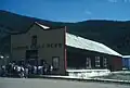
| Harrington’s Store (15)
|
Dawson City YT
|
64°03′38″N 139°26′02″W / 64.0606°N 139.434°W / 64.0606; -139.434 (Harrington’s Store (15))
|
Federal (9829)
|
Q61499677
|
More images
|
| North West Mounted Police Stables
|
Dawson City YT
|
64°03′26″N 139°26′17″W / 64.0572°N 139.438°W / 64.0572; -139.438 (North West Mounted Police Stables)
|
Federal (9842)
|
Q61499665
|
Upload Photo
|
| North West Mounted Police Jail
|
Dawson City YT
|
64°03′25″N 139°26′13″W / 64.057°N 139.437°W / 64.057; -139.437 (North West Mounted Police Jail)
|
Federal (9854)
|
Q61499746
|
Upload Photo
|
| Northern Commercial Company Warehouse
|
Dawson City YT
|
64°03′42″N 139°25′37″W / 64.0617°N 139.427°W / 64.0617; -139.427 (Northern Commercial Company Warehouse)
|
Federal (10373)
|
Q61499662
|
Upload Photo
|
| Root Cellar
|
Dawson City YT
|
64°01′39″N 139°14′46″W / 64.0276°N 139.246°W / 64.0276; -139.246 (Root Cellar)
|
Federal (11208)
|
Q61499716
|
Upload Photo
|
| General Manager's House
|
Dawson City YT
|
64°01′39″N 139°14′35″W / 64.0276°N 139.243°W / 64.0276; -139.243 (General Manager's House)
|
Federal (11213)
|
Q61499733
|
Upload Photo
|
| Tr'ochëk National Historic Site
|
Dawson City YT
|
64°03′04″N 139°26′28″W / 64.0512°N 139.441°W / 64.0512; -139.441 (Tr'ochëk National Historic Site)
|
Federal (14661)
|
Q2457306
|
More images
|
| Dawson Daily News
|
123 3rd Avenue
Dawson City YT
|
64°03′43″N 139°25′55″W / 64.062°N 139.432°W / 64.062; -139.432 (Dawson Daily News)
|
Federal (11264)
|
Q61499759
|
More images
|
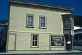
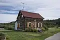
| Yukon Sawmill Company Office
|
1302 Front Street
Dawson City YT
|
64°03′57″N 139°25′48″W / 64.0657°N 139.43°W / 64.0657; -139.43 (Yukon Sawmill Company Office)
|
Yukon (4832)
|
Q105948221
|
More images
|
| Ruby's Place
|
233 Second Avenue
Dawson City YT
|
64°03′41″N 139°26′02″W / 64.0615°N 139.434°W / 64.0615; -139.434 (Ruby's Place)
|
Federal (10372)
|
Q61499667
|
More images
|
| Third Avenue Hotel, Building 14
|
309-11 Third Avenue
Dawson City YT
|
64°03′45″N 139°25′52″W / 64.0625°N 139.431°W / 64.0625; -139.431 (Third Avenue Hotel, Building 14)
|
Federal (6227)
|
Q61499678
|

More images
|
| Commanding Officer's Residence (10)
|
508 Fifth Avenue
Dawson City YT
|
64°03′17″N 139°26′17″W / 64.0547°N 139.438°W / 64.0547; -139.438 (Commanding Officer's Residence (10))
|
Federal (9825)
|
Q61499675
|
Upload Photo
|
| Dawson City Telegraph Office
|
512 Seventh Avenue
Dawson City YT
|
64°03′21″N 139°25′59″W / 64.0558°N 139.433°W / 64.0558; -139.433 (Dawson City Telegraph Office)
|
Yukon (3920)
|
Q104536850
|
More images
|
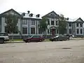
| Old Territorial Administration Building National Historic Site
|
595 Fifth Avenue
Dawson City YT
|
64°03′21″N 139°26′13″W / 64.0559°N 139.437°W / 64.0559; -139.437 (Old Territorial Administration Building National Historic Site)
|
Federal (15784)
|
Q22975456
|
More images
|
| St. Andrew's Manse
|
601 Fourth Avenue
Dawson City YT
|
64°03′45″N 139°25′52″W / 64.0625°N 139.431°W / 64.0625; -139.431 (St. Andrew's Manse)
|
Federal (10364)
|
Q61499679
|
Upload Photo
|
| Auto Repair Shop, Building #7
|
Bear Creek Compound
Dawson City YT
|
64°01′37″N 139°14′35″W / 64.027040°N 139.243150°W / 64.027040; -139.243150 (Auto Repair Shop, Building #7)
|
Federal (6232)
|
Q61499684
|
Upload Photo
|
| Carpentry Shop, Building #6
|
Bear Creek Compound
Dawson City YT
|
64°01′36″N 139°14′36″W / 64.026790°N 139.243270°W / 64.026790; -139.243270 (Carpentry Shop, Building #6)
|
Federal (6235)
|
Q61499701
|
Upload Photo
|
| Cat Repair Shop, Building #8
|
Bear Creek Compound
Dawson City YT
|
64°01′37″N 139°14′34″W / 64.027030°N 139.242830°W / 64.027030; -139.242830 (Cat Repair Shop, Building #8)
|
Federal (6242)
|
Q61499696
|
Upload Photo
|
| Garage and Fire Hall
|
Bear Creek Compound
Dawson City YT
|
64°01′39″N 139°14′33″W / 64.027540°N 139.2425°W / 64.027540; -139.2425 (Garage and Fire Hall)
|
Federal (11215)
|
Q61499686
|
Upload Photo
|
| Garage and Storage Building
|
Bear Creek Compound
Dawson City YT
|
64°01′39″N 139°14′32″W / 64.0276°N 139.2423°W / 64.0276; -139.2423 (Garage and Storage Building)
|
Federal (11227)
|
Q61499657
|
Upload Photo
|
| Gas House
|
Bear Creek Compound
Dawson City YT
|
64°01′35″N 139°14′33″W / 64.0263°N 139.242620°W / 64.0263; -139.242620 (Gas House)
|
Federal (10778)
|
Q61499707
|
Upload Photo
|
| Mess Hall and Bunkhouse
|
Bear Creek Compound
Dawson City YT
|
64°01′41″N 139°14′38″W / 64.027950°N 139.243750°W / 64.027950; -139.243750 (Mess Hall and Bunkhouse)
|
Federal (11210)
|
Q61499712
|
Upload Photo
|
| Staff House
|
Bear Creek Compound
Dawson City YT
|
64°01′37″N 139°14′31″W / 64.0270°N 139.2420°W / 64.0270; -139.2420 (Staff House)
|
Federal (11112)
|
Q61499717
|
Upload Photo
|
| Tin Shop
|
Bear Creek Compound
Dawson City YT
|
64°01′36″N 139°14′35″W / 64.026730°N 139.243040°W / 64.026730; -139.243040 (Tin Shop)
|
Federal (9882)
|
Q61499720
|
Upload Photo
|
| Troberg Residence, Building #67
|
Bear Creek Compound
Dawson City YT
|
64°01′48″N 139°14′16″W / 64.029890°N 139.237770°W / 64.029890; -139.237770 (Troberg Residence, Building #67)
|
Federal (9890)
|
Q61499722
|
Upload Photo
|
| V.I.P. Guest House
|
Bear Creek Compound
Dawson City YT
|
64°01′38″N 139°14′30″W / 64.027320°N 139.241620°W / 64.027320; -139.241620 (V.I.P. Guest House)
|
Federal (9922)
|
Q61499726
|
Upload Photo
|
| Warehouse No. 1, Building #27
|
Bear Creek Compound
Dawson City YT
|
64°01′38″N 139°14′40″W / 64.027120°N 139.244450°W / 64.027120; -139.244450 (Warehouse No. 1, Building #27)
|
Federal (9923)
|
Q61499729
|
Upload Photo
|
| Warehouse No. 2
|
Bear Creek Compound
Dawson City YT
|
64°00′N 139°14′W / 64.0°N 139.24°W / 64.0; -139.24 (Warehouse No. 2)
|
Federal (10819)
|
Q61499687
|
Upload Photo
|
| Warehouse No. 3, Building #35
|
Bear Creek Compound
Dawson City YT
|
64°01′38″N 139°14′45″W / 64.027170°N 139.245870°W / 64.027170; -139.245870 (Warehouse No. 3, Building #35)
|
Federal (9924)
|
Q61499671
|
Upload Photo
|
| Engineering Office (Building 19)
|
Bear Creek Compound
Dawson City YT
|
64°01′40″N 139°14′37″W / 64.027680°N 139.243530°W / 64.027680; -139.243530 (Engineering Office (Building 19))
|
Federal (9925)
|
Q61499704
|
Upload Photo
|
| Engineering Office (Building 28)
|
Bear Creek Compound
Dawson City YT
|
64°01′38″N 139°14′41″W / 64.027240°N 139.244700°W / 64.027240; -139.244700 (Engineering Office (Building 28))
|
Federal (9926)
|
Q61499890
|
Upload Photo
|
| Gold Room. Building #29
|
Bear Creek Compound
Dawson City YT
|
64°01′39″N 139°14′44″W / 64.027470°N 139.24552°W / 64.027470; -139.24552 (Gold Room. Building #29)
|
Federal (11214)
|
Q61499710
|
Upload Photo
|
| Machine Shop, Building #1 & #2
|
Bear Creek Compound
Dawson City YT
|
64°01′37″N 139°14′38″W / 64.026860°N 139.24383°W / 64.026860; -139.24383 (Machine Shop, Building #1 & #2)
|
Federal (11226)
|
Q61499743
|
Upload Photo
|
| St. Andrew's Presbyterian Church
|
Church / Fourth Street
Dawson City YT
|
64°03′45″N 139°25′52″W / 64.0625°N 139.431°W / 64.0625; -139.431 (St. Andrew's Presbyterian Church)
|
Federal (10366)
|
Q61499663
|
.jpg)
More images
|
| Former Territorial Court House National Historic Site
|
Corner of Front and Turner Streets
Dawson City YT
|
64°03′23″N 139°26′28″W / 64.0563°N 139.441°W / 64.0563; -139.441 (Former Territorial Court House National Historic Site)
|
Federal (12743, (16081)
|
Q22975459
|
More images
|
| Robert Service Cabin
|
Eighth / Hansen Street
Dawson City YT
|
64°03′45″N 139°25′52″W / 64.0625°N 139.431°W / 64.0625; -139.431 (Robert W. Service#Dawson City cabinRobert Service Cabin)
|
Federal (10368)
|
Q61499750
|

More images
|
| Black Residence, No. 9
|
Fifth Avenue and Turner Street
Dawson City YT
|
64°03′15″N 139°26′17″W / 64.0542°N 139.438°W / 64.0542; -139.438 (Black Residence, No. 9)
|
Federal (6226)
|
Q61499669
|
Upload Photo
|
| Yukon Hotel National Historic Site
|
First Avenue
Dawson City YT
|
64°03′33″N 139°26′17″W / 64.0591°N 139.438°W / 64.0591; -139.438 (Yukon Hotel National Historic Site)
|
Federal (9163)
|
Q8060826
|
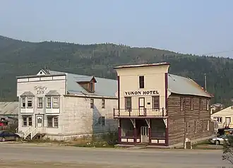
More images
|
| Commissioner's Residence
|
Front Street
Dawson City YT
|
64°03′24″N 139°26′28″W / 64.0567°N 139.441°W / 64.0567; -139.441 (Commissioner's Residence)
|
Federal (15641)
|
Q61499655
|
More images
|
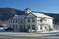
| Post Office
|
King Street and Third Avenue
Dawson City YT
|
64°03′47″N 139°25′52″W / 64.063°N 139.431°W / 64.063; -139.431 (Post Office)
|
Federal (11629)
|
Q61499660
|
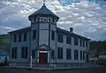
More images
|
| Winaut's Store
|
Second Avenue
Dawson City YT
|
64°03′23″N 139°26′10″W / 64.0565°N 139.436°W / 64.0565; -139.436 (Winaut's Store)
|
Federal (6241)
|
Q61499751
|
Upload Photo
|
| Dawson Historical Complex National Historic Site
|
Third Avenue
Dawson City YT
|
64°03′48″N 139°25′52″W / 64.0634°N 139.431°W / 64.0634; -139.431 (Dawson Historical Complex National Historic Site)
|
Federal (6253)
|
Q22975467
|
More images
|
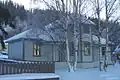
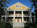
| Mabel Mcintyre House
|
12 Centre Street
Mayo YT
|
63°35′36″N 135°53′46″W / 63.5932°N 135.896°W / 63.5932; -135.896 (Mabel Mcintyre House)
|
Yukon (1282)
|
Q132816830
|
Upload Photo
|
| Mayo Legion Hall
|
310 First Ave
Mayo YT
|
63°35′28″N 135°53′42″W / 63.5912°N 135.895°W / 63.5912; -135.895 (Mayo Legion Hall)
|
Yukon (6585)
|
Q132816869
|
Upload Photo
|
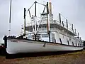
| SS Klondike National Historic Site
|
Whitehorse YT
|
60°42′48″N 135°02′53″W / 60.7133°N 135.048°W / 60.7133; -135.048 (SS Klondike National Historic Site)
|
Federal (9348)
|
Q7393932
|
More images
|
| Smith House
|
3128 Third Ave. Whitehorse LePage Park
Whitehorse YT
|
60°43′14″N 135°03′19″W / 60.7206°N 135.0553°W / 60.7206; -135.0553 (Smith House)
|
Whitehorse municipality (8903)
|
Q132816902
|
.jpg)
More images
|
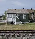
| Train Crew's House 1
|
1091 First Ave
Whitehorse YT
|
60°43′07″N 135°02′56″W / 60.7187°N 135.049°W / 60.7187; -135.049 (Train Crew's House 1)
|
Whitehorse municipality (15133)
|
Q132816913
|
More images
|
| Train Crew's House 2
|
1093 First Avenue
Whitehorse YT
|
60°43′08″N 135°02′56″W / 60.7188°N 135.049°W / 60.7188; -135.049 (Train Crew's House 2)
|
Whitehorse municipality (15134)
|
Q132816933
|
Upload Photo
|
| Old Firehall
|
1105 First Avenue
Whitehorse YT
|
60°43′10″N 135°03′00″W / 60.7195°N 135.05°W / 60.7195; -135.05 (Old Firehall)
|
Whitehorse municipality (14867)
|
Q132816956
|
.jpg)
More images
|
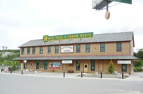
| White Pass and Yukon Route Railway Depot
|
1109 First Ave
Whitehorse YT
|
60°43′12″N 135°03′00″W / 60.7201°N 135.05°W / 60.7201; -135.05 (White Pass and Yukon Route Railway Depot)
|
Whitehorse municipality (4471)
|
Q117825828
|
More images
|
| Building 200
|
200 Range Road
Whitehorse YT
|
60°44′17″N 135°05′17″W / 60.7381°N 135.088°W / 60.7381; -135.088 (Building 200)
|
Federal (10792)
|
Q61499688
|
Upload Photo
|
| Log Skyscrapers
|
208 Lambert Street
Whitehorse YT
|
60°43′04″N 135°03′07″W / 60.7179°N 135.052°W / 60.7179; -135.052 (Log Skyscrapers)
|
Whitehorse municipality (1903)
|
Q132816975
|
More images
|
| T.C. Richards Building
|
302 Steele Street
Whitehorse YT
|
60°43′12″N 135°03′18″W / 60.72°N 135.055°W / 60.72; -135.055 (T.C. Richards Building)
|
Whitehorse municipality (4574)
|
Q132816995
|
Upload Photo
|
| Donnenworth House
|
3126 Third Avenue
Whitehorse YT
|
60°43′13″N 135°03′18″W / 60.7204°N 135.055°W / 60.7204; -135.055 (Donnenworth House)
|
Whitehorse municipality (6592)
|
Q132817012
|
More images
|
| The Taylor House
|
412 Main Street
Whitehorse YT
|
60°43′08″N 135°03′29″W / 60.7188°N 135.058°W / 60.7188; -135.058 (The Taylor House)
|
Yukon (4833)
|
Q132817047
|
Upload Photo
|
| Pioneer Hotel 2
|
Shipyards Park
Whitehorse YT
|
60°43′42″N 135°03′18″W / 60.7284°N 135.055°W / 60.7284; -135.055 (Pioneer Hotel 2)
|
Whitehorse municipality (8904)
|
Q132817077
|
More images
|
| T'äw Tà'är National Historic Site of Canada
|
30 miles east of Lake Laberge on the Teslin River
Teslin River, Yukon YT
|
61°14′37″N 134°37′00″W / 61.2435°N 134.6168°W / 61.2435; -134.6168 (T'aw Taaar National Historic Site of Canada)
|
Federal (19568)
|
Q22975472
|
Upload Photo
|
| AJ Goddard Shipwreck
|
Lake Laberge, 200 meters from Goddard Point
Yukon YT
|
61°21′29″N 135°14′03″W / 61.3580579°N 135.2342177°W / 61.3580579; -135.2342177 (AJ Goddard Shipwreck)
|
|
Q132817449
|
Upload Photo
|
| Archdeacon McDonald Memorial Church and St Luke’s Church
|
Old Crow
Yukon YT
|
67°34′16″N 139°50′02″W / 67.5712153°N 139.8339201°W / 67.5712153; -139.8339201 (Archdeacon McDonald Memorial Church and St Luke’s Church)
|
|
Q132817471
|
Upload Photo
|
| Arctic Brotherhood Hall
|
Lots 1 and 2, Block S, Ladue Estate
Dawson City, Yukon YT
|
64°03′41″N 139°25′49″W / 64.0615004°N 139.4302375°W / 64.0615004; -139.4302375 (Arctic Brotherhood Hall)
|
|
Q132817553
|
Upload Photo
|
| Captain Martin House
|
305 Wood Street
Whitehorse, Yukon YT
|
60°43′14″N 135°03′22″W / 60.7206°N 135.0562129°W / 60.7206; -135.0562129 (Captain Martin House)
|
|
Q132817571
|
Upload Photo
|
| Casey Car House
|
First Avenue
Whitehorse, Yukon YT
|
60°43′03″N 135°02′52″W / 60.7176°N 135.0478°W / 60.7176; -135.0478 (Casey Car House)
|
|
Q132818601
|
Upload Photo
|
| Ëdhä dädhëchą (Moosehide Slide)
|
Dawson City, Yukon YT
|
64°04′19″N 139°24′56″W / 64.072°N 139.4155°W / 64.072; -139.4155 (Ëdhä dädhëchą)
|
|
Q120736239
|
Upload Photo
|
| Fort Selkirk
|
Lot 1021, Plan 2008-0123
Yukon YT
|
62°46′30″N 137°23′28″W / 62.7749604°N 137.3909832°W / 62.7749604; -137.3909832 (Fort Selkirk)
|
|
Q782621
|

More images
|
| Gindèhchik–Rampart House
|
Yukon YT
|
67°25′02″N 140°59′52″W / 67.4170876°N 140.9977785°W / 67.4170876; -140.9977785 (Rampart House)
|
|
Q116311774
|
Upload Photo
|
| Hulland House
|
704 Wood Street
Whitehorse, Yukon YT
|
60°43′10″N 135°03′51″W / 60.719384°N 135.064144°W / 60.719384; -135.064144 (Hulland House)
|
|
Q132818653
|
Upload Photo
|
| Minto Park
|
blocks 3 and 5, Government Reserve
Dawson City, Yukon YT
|
64°03′26″N 139°26′04″W / 64.05722°N 139.43444°W / 64.05722; -139.43444 (Minto Park)
|
|
Q132818657
|
Upload Photo
|
| Old Log Church and Rectory
|
303 Elliott Street
Whitehorse, Yukon YT
|
60°43′06″N 135°03′14″W / 60.718419°N 135.053979°W / 60.718419; -135.053979 (Old Log Church and Rectory)
|
|
Q132818665
|
Upload Photo
|
| P. Denhardt Cabin
|
Dawson City, Yukon YT
|
64°04′06″N 139°25′24″W / 64.0682469°N 139.4232371°W / 64.0682469; -139.4232371 (P. Denhardt Cabin)
|
|
Q132818667
|
Upload Photo
|
| Telegraph Office
|
1124 First Avenue
Whitehorse, Yukon YT
|
60°43′16″N 135°03′05″W / 60.721059°N 135.051369°W / 60.721059; -135.051369 (Telegraph Office)
|
|
Q132818671
|
Upload Photo
|
| Watson Lake Air Terminal Building
|
Watson Lake Airport
Watson Lake, Yukon YT
|
60°06′50″N 128°49′23″W / 60.1137574°N 128.8230529°W / 60.1137574; -128.8230529 (Watson Lake Air Terminal Building)
|
|
Q132818678
|
Upload Photo
|
| Watson Lake Sign Post Forest
|
Lot 1014-2
Watson Lake, Yukon YT
|
60°03′48″N 128°42′51″W / 60.063333°N 128.714167°W / 60.063333; -128.714167 (Watson Lake Sign Post Forest)
|
|
Q2377153
|
[[File:|100px]]
More images
|