| Name
|
Address
|
Coordinates
|
Government recognition (CRHP №)
|

|
Image
|
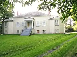
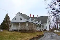
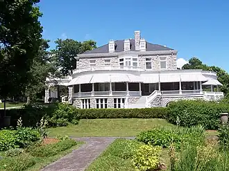
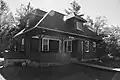
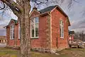
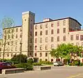
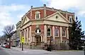
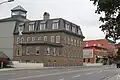
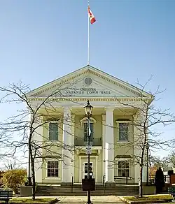
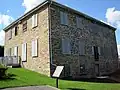
| Homewood
|
1372 County Road 2
Augusta ON
|
44°39′21″N 75°35′17″W / 44.6558°N 75.5881°W / 44.6558; -75.5881 (Homewood)
|
Federal (12013),
Ontario (8870)
|
|
More images
|
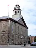
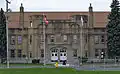
| Armoury
|
1-9 East Avenue
Brockville ON
|
44°35′39″N 75°40′42″W / 44.5943°N 75.6784°W / 44.5943; -75.6784 (Armoury)
|
Federal (4809)
|
|
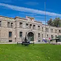
More images
|
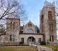
| Former Brockville Post Office National Historic Site of Canada
|
14 Court House Avenue
Brockville ON
|
44°35′24″N 75°41′05″W / 44.5899°N 75.6847°W / 44.5899; -75.6847 (Former Brockville Post Office National Historic Site of Canada)
|
Federal (1135)
|
|

More images
|
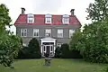
| Fulford Place National Historic Site of Canada
|
287 King Street East
Brockville ON
|
44°35′53″N 75°40′16″W / 44.598°N 75.671°W / 44.598; -75.671 (Fulford Place National Historic Site of Canada)
|
Federal (10173)
|
|
More images
|
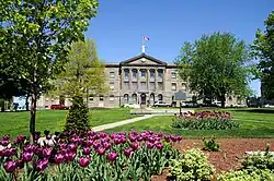
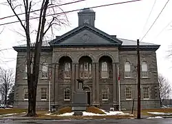
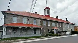
| Leeds and Grenville County Court House National Historic Site of Canada
|
1 Court House Square
Brockville ON
|
44°35′28″N 75°41′09″W / 44.591°N 75.6859°W / 44.591; -75.6859 (Leeds and Grenville County Court House National Historic Site of Canada)
|
Federal (7635)
|
|
More images
|
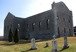
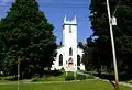
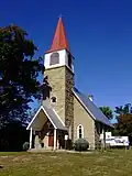
| St. Paul's Church (Delta)
|
77 King Street
Delta ON
|
44°36′25″N 76°07′16″W / 44.6070°N 76.1211°W / 44.6070; -76.1211 (St. Paul's Church (Delta))
|
Federal (8480)
|
|
More images
|
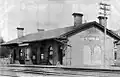
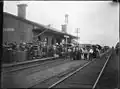
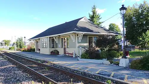
| Former Grand Trunk Railway (Canadian National Railways) Station
|
Ernestown ON
|
44°13′02″N 76°45′17″W / 44.2171°N 76.754803°W / 44.2171; -76.754803 (Former Grand Trunk Railway (Canadian National Railways) Station (Ernestown))
|
Federal (4551)
|
|
.jpg)
More images
|
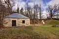
| Adelaide Island Picnic Shelter
|
St. Lawrence Islands National Park of Canada
Front of Yonge ON
|
44°26′04″N 75°50′24″W / 44.4344°N 75.8399°W / 44.4344; -75.8399 (Adelaide Island Picnic Shelter)
|
Federal (11128)
|
|

Upload Photo
|
| Aubrey Island Picnic Shelter
|
St. Lawrence Islands National Park of Canada
Front of Yonge ON
|
44°17′45″N 76°11′35″W / 44.2958°N 76.193°W / 44.2958; -76.193 (Aubrey Island Picnic Shelter)
|
Federal (11093)
|
|
Upload Photo
|
| Batterman's Point Complex
|
Batterman's Point, St. Lawrence Islands National Park of Canada
Front of Yonge ON
|
44°21′58″N 75°57′15″W / 44.366°N 75.9541°W / 44.366; -75.9541 (Batterman's Point Complex)
|
Federal (11620)
|
|
Upload Photo
|
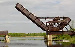
| Bridge Island / Chimney Island National Historic Site of Canada
|
Chimney Island
Front of Yonge ON
|
44°28′07″N 75°50′03″W / 44.4686°N 75.8342°W / 44.4686; -75.8342 (Bridge Island / Chimney Island National Historic Site of Canada)
|
Federal (17987)
|
|
Upload Photo
|
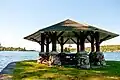
| Gazebo
|
St. Lawrence Islands National Park of Canada
Front of Yonge ON
|
44°22′00″N 75°57′13″W / 44.3667°N 75.9537°W / 44.3667; -75.9537 (Gazebo)
|
Federal (11355)
|
|
More images
|
| Gordon Island Pavilion
|
St. Lawrence Islands National Park of Canada
Front of Yonge ON
|
44°19′51″N 76°06′08″W / 44.3309°N 76.1021°W / 44.3309; -76.1021 (Gordon Island Pavilion)
|
Federal (10048)
|
|
Upload Photo
|
| Limberlost
|
Batterman's Point, St. Lawrence Islands National Park of Canada
Front of Yonge ON
|
44°21′56″N 75°57′16″W / 44.3655°N 75.9544°W / 44.3655; -75.9544 (Limberlost)
|
Federal (11130)
|
|
|
| Mallorytown Landing Pavilion
|
Front of Yonge ON
|
44°27′05″N 75°51′33″W / 44.4514°N 75.8591°W / 44.4514; -75.8591 (Mallorytown Landing Pavilion)
|
Federal (11125)
|
|
Upload Photo
|
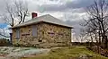
| Massey Farmstead
|
eastern end of Grenadier Island, St. Lawrence Islands National Park of Canada
Front of Yonge ON
|
44°25′30″N 75°51′01″W / 44.425°N 75.8502°W / 44.425; -75.8502 (Massey Farmstead)
|
Federal (11510)
|
|
Upload Photo
|
| Shelter
|
Beaurivage Island
St. Lawrence Islands National Park of Canada ON
|
44°18′12″N 76°11′15″W / 44.3034°N 76.1874°W / 44.3034; -76.1874 (Shelter (Beaurivage Island))
|
Federal (14861)
|
|
Upload Photo
|
| Shelter
|
Camelot Island
St. Lawrence Islands National Park of Canada ON
|
44°18′05″N 76°06′41″W / 44.3015°N 76.1113°W / 44.3015; -76.1113 (Shelter (Camelot Island))
|
Federal (14827)
|
|
Upload Photo
|
| Shelter
|
Endymion Island
St. Lawrence Islands National Park of Canada ON
|
44°18′09″N 76°05′56″W / 44.3026°N 76.0988°W / 44.3026; -76.0988 (Shelter (Endymion Island))
|
Federal (14828)
|
|
Upload Photo
|
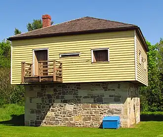
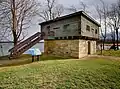
| Water Tower
|
Batterman's Point, St. Lawrence Islands National Park of Canada
Front of Yonge ON
|
44°21′59″N 75°57′12″W / 44.3663°N 75.9534°W / 44.3663; -75.9534 (Water Tower)
|
Federal (11131)
|
|
Upload Photo
|
| West Grenadier Island Pavilion
|
St. Lawrence Islands National Park of Canada
Front of Yonge ON
|
44°23′00″N 75°54′20″W / 44.3834°N 75.9056°W / 44.3834; -75.9056 (West Grenadier Island Pavilion)
|
Federal (11060)
|
|
Upload Photo
|
| Lansdowne Iron Works National Historic Site of Canada
|
County Rd. 33 50 m west of Lyndhurst Bridge
Lyndhurst ON
|
44°32′58″N 76°07′34″W / 44.5495°N 76.1261°W / 44.5495; -76.1261 (Lansdowne Iron Works National Historic Site of Canada)
|
Federal (18951)
|
|
Upload Photo
|
| Pointe au Baril National Historic Site of Canada
|
20m on north side of Highway 2
Maitland ON
|
44°38′15″N 75°36′36″W / 44.6375°N 75.6099°W / 44.6375; -75.6099 (Pointe au Baril National Historic Site of Canada)
|
Federal (20107)
|
|
Upload Photo
|
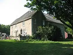
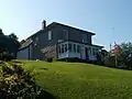
| Aaron Merrick House
|
905 St. Lawrence Street
Merrickville–Wolford ON
|
44°54′37″N 75°50′08″W / 44.9102°N 75.8355°W / 44.9102; -75.8355 (Aaron Merrick House)
|
Merrickville–Wolford municipality (17601)
|
|
|
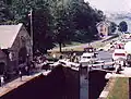
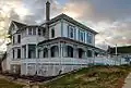
| Defensible Lockmaster's House
|
Clowes Lock, Rideau Canal National Historic Site of Canada
Merrickville–Wolford ON
|
44°56′42″N 75°49′19″W / 44.945°N 75.822°W / 44.945; -75.822 (Defensible Lockmaster's House (Clowes Lock, Merrickville-Wolford))
|
Federal (10924)
|
|
Upload Photo
|
| Defensible Lockmaster's House
|
Nicholson Lock, Rideau Canal National Historic Site of Canada
Merrickville–Wolford ON
|
44°57′03″N 75°49′03″W / 44.9508°N 75.8174°W / 44.9508; -75.8174 (Defensible Lockmaster's House (Nicholsons Lock, Merrickville-Wolford))
|
Federal (10946)
|
|
Upload Photo
|
| Foundry
|
On an island in the Rideau River, at Merrickville Lockstation
Merrickville–Wolford ON
|
44°55′04″N 75°50′13″W / 44.9177°N 75.837°W / 44.9177; -75.837 (Foundry)
|
Federal (11071)
|
|
Upload Photo
|
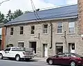
| Hutchins-Heroux Commercial Building
|
212 St. Lawrence Street
Merrickville–Wolford ON
|
44°54′55″N 75°50′12″W / 44.9153°N 75.8367°W / 44.9153; -75.8367 (Hutchins-Heroux Commercial Building)
|
Merrickville–Wolford municipality (17602)
|
|
|
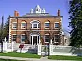
| Jakes-McLean Block
|
105 St. Lawrence Street
Merrickville–Wolford ON
|
44°54′58″N 75°50′12″W / 44.916°N 75.8367°W / 44.916; -75.8367 (Jakes-McLean Block)
|
Ontario (7694)
|
|
Upload Photo
|
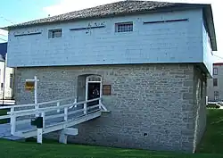
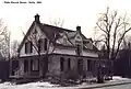
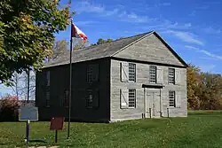
| Merrickville Blockhouse
|
279 Saint Lawrence Street
Merrickville–Wolford ON
|
44°55′00″N 75°50′15″W / 44.9168°N 75.8375°W / 44.9168; -75.8375 (Merrickville Blockhouse)
|
Federal (4358, (7445)
|
|
More images
|
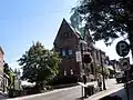
| 8 Mary Street
|
8 Mary Street
North Grenville ON
|
45°00′54″N 75°38′28″W / 45.0149°N 75.6412°W / 45.0149; -75.6412 (8 Mary Street)
|
North Grenville municipality (17301)
|
|
Upload Photo
|
| Actons Corners School
|
1631 Highway 43
North Grenville ON
|
45°00′20″N 75°41′04″W / 45.0056°N 75.6844°W / 45.0056; -75.6844 (Actons Corners School)
|
North Grenville municipality (17302)
|
|
Upload Photo
|
| Kemptville Public Library
|
207 Prescott Street
North Grenville (Kemptville) ON
|
45°00′54″N 75°38′41″W / 45.0149°N 75.6447°W / 45.0149; -75.6447 (Kemptville Public Library)
|
North Grenville (Kemptville) municipality (17321)
|
|
Upload Photo
|
| Lyman Clothier House
|
8 Clothier Street West
North Grenville (Kemptville) ON
|
45°00′58″N 75°38′53″W / 45.016°N 75.648°W / 45.016; -75.648 (Lyman Clothier House)
|
North Grenville (Kemptville) municipality (17384)
|
|
Upload Photo
|
| Maplewood Hall
|
92 Maplewood Avenue
North Grenville ON
|
44°57′47″N 75°40′42″W / 44.963°N 75.6784°W / 44.963; -75.6784 (Maplewood Hall)
|
North Grenville municipality (17383)
|
|
Upload Photo
|
| Oxford-on-Rideau Township Hall National Historic Site of Canada
|
100 Maplewood Street
North Grenville ON
|
44°58′00″N 75°41′00″W / 44.9667°N 75.6833°W / 44.9667; -75.6833 (Oxford-on-Rideau Township Hall National Historic Site of Canada)
|
Federal (7690),
North Grenville municipality (17382)
|
|
Upload Photo
|
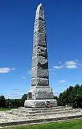
| Battle of the Windmill National Historic Site of Canada
|
County Road 2 East
Prescott ON
|
44°43′16″N 75°29′13″W / 44.7211°N 75.4869°W / 44.7211; -75.4869 (Battle of the Windmill National Historic Site of Canada)
|
Federal (13962)
|
|
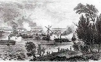
More images
|
| Battle of the Windmill Windmill Tower
|
Prescott ON
|
44°42′47″N 75°30′33″W / 44.713°N 75.5091°W / 44.713; -75.5091 (Battle of the Windmill Windmill Tower)
|
Federal (4736, (20373)
|
|
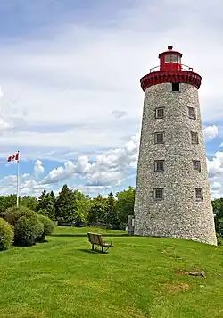
More images
|
| Caponier
|
Fort Wellington National Historic Site
Prescott ON
|
44°42′46″N 75°30′30″W / 44.7127°N 75.5082°W / 44.7127; -75.5082 (Caponier)
|
Federal (10099)
|
|
Upload Photo
|
| Former Grand Trunk Railway (Canadian National Railways) Station
|
St. Lawrence and Railway Streets
Prescott ON
|
44°42′40″N 75°31′30″W / 44.711°N 75.525°W / 44.711; -75.525 (Former Grand Trunk Railway (Canadian National Railways) Station)
|
Federal (4550)
|
|
More images
|
| Fort Wellington National Historic Site of Canada
|
King Street
Prescott ON
|
44°42′47″N 75°30′32″W / 44.7131°N 75.509°W / 44.7131; -75.509 (Fort Wellington National Historic Site of Canada)
|
Federal (7618, (9818)
|
|
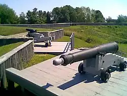
More images
|
| Latrine
|
Fort Wellington National Historic Site
Prescott ON
|
44°42′47″N 75°30′32″W / 44.7131°N 75.509°W / 44.7131; -75.509 (Latrine)
|
Federal (9797)
|
|
Upload Photo
|
| Officers' Quarters
|
Fort Wellington National Historic Site
Prescott ON
|
44°42′47″N 75°30′32″W / 44.7131°N 75.509°W / 44.7131; -75.509 (Officers' Quarters)
|
Federal (9786)
|
|
Upload Photo
|
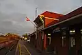
| Prescott Railway Station (Grand Trunk) National Historic Site of Canada
|
820 St. Lawrence Street
Prescott ON
|
44°42′40″N 75°31′29″W / 44.711°N 75.5246°W / 44.711; -75.5246 (Prescott Railway Station (Grand Trunk) National Historic Site of Canada)
|
Federal (7659)
|
|
More images
|
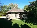
| Blacksmith's Shop
|
Near the Jones Falls lock station
Rideau Lakes ON
|
44°32′45″N 76°14′18″W / 44.5459°N 76.2382°W / 44.5459; -76.2382 (Blacksmith's Shop)
|
Federal (9819)
|
|
More images
|
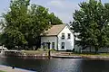
| Cottage
|
Colonel By Island
Rideau Lakes ON
|
44°44′08″N 76°13′16″W / 44.7355°N 76.2212°W / 44.7355; -76.2212 (Cottage)
|
Federal (10326)
|
|
Upload Photo
44.647310, -76.321689
|
| Blockhouse
|
Blockhouse Lane, Newboro
Rideau Lakes ON
|
44°42′12″N 76°17′45″W / 44.7032°N 76.2959°W / 44.7032; -76.2959 (Blockhouse (Newboro))
|
Federal (10991)
|
|
|
| Blockhouse
|
Narrow Lakes Road at the Rideau Canal
Rideau Lakes ON
|
44°42′12″N 76°17′45″W / 44.7032°N 76.2959°W / 44.7032; -76.2959 (Blockhouse (Narrows))
|
Federal (10858)
|
|
|
| Defensible Lockmaster's House
|
Rideau Canal National Historic Site of Canada
Rideau Lakes ON
|
44°53′35″N 76°03′22″W / 44.893°N 76.056°W / 44.893; -76.056 (Defensible Lockmaster's House (Poonamalie Lock, Rideau Lakes))
|
Federal (10916)
|
|
|
| Defensible Lockmaster's House
|
Jones Falls Lockstation
Rideau Lakes (Jones Falls) ON
|
44°32′49″N 76°14′17″W / 44.547°N 76.238°W / 44.547; -76.238 (Defensible Lockmaster's House (Jones Falls Lock, Rideau Lakes))
|
Federal (10992)
|
|
|
| Defensible Lockmaster's House
|
Chaffeys Lockstation
Rideau Lakes (Chaffeys Falls) ON
|
44°34′44″N 76°19′10″W / 44.5789°N 76.3194°W / 44.5789; -76.3194 (Defensible Lockmaster's House (Chaffeys Lock, Rideau Lakes))
|
Federal (4765)
|
|
|
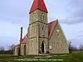
| Elgin United Church
|
77 Main Street
Rideau Lakes (Elgin) ON
|
44°36′36″N 76°13′07″W / 44.61°N 76.2187°W / 44.61; -76.2187 (Elgin United Church)
|
Rideau Lakes (Elgin) municipality (8344)
|
|
More images
|
| Emmanuel Anglican Church
|
2767 Highway 15
Rideau Lakes (Portland) ON
|
44°41′16″N 76°12′15″W / 44.6878°N 76.2042°W / 44.6878; -76.2042 (Emmanuel Anglican Church)
|
Rideau Lakes (Portland) municipality (8411)
|
|
More images
|
| The Guthrie House
|
10 Perth Street
Rideau Lakes (Elgin) ON
|
44°36′29″N 76°13′23″W / 44.6081°N 76.223°W / 44.6081; -76.223 (The Guthrie House)
|
Rideau Lakes (Elgin) municipality (8483)
|
|
More images
|
| The Horace Sheldon House
|
3196 Sheldon Road
Rideau Lakes (Portland) ON
|
44°41′38″N 76°13′09″W / 44.6939°N 76.2193°W / 44.6939; -76.2193 (The Horace Sheldon House)
|
Rideau Lakes (Portland) municipality (17282)
|
|
Upload Photo
|
| John Green House
|
2346 Harlem Road
Rideau Lakes (Harlem) ON
|
44°40′24″N 76°08′59″W / 44.6732°N 76.1496°W / 44.6732; -76.1496 (John Green House)
|
Rideau Lakes (Harlem) municipality (9559)
|
|
Upload Photo
|
| Morton-McLeod House
|
12 Queen Street
Rideau Lakes (Morton) ON
|
44°32′16″N 76°11′54″W / 44.5377°N 76.1983°W / 44.5377; -76.1983 (Morton-McLeod House)
|
Rideau Lakes (Morton) municipality (17281)
|
|
Upload Photo
|
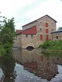
| Old Stone Mill National Historic Site of Canada
|
Highway 42
Rideau Lakes ON
|
44°36′37″N 76°07′21″W / 44.6102°N 76.1224°W / 44.6102; -76.1224 (Old Stone Mill National Historic Site of Canada)
|
Federal (12127),
Rideau Lakes municipality (8427)
|
|
More images
|
| Pennock-St. Pierre House
|
176 Charland Road
Rideau Lakes (Elgin) ON
|
44°37′28″N 76°13′12″W / 44.6244°N 76.2199°W / 44.6244; -76.2199 (Pennock-St. Pierre House)
|
Rideau Lakes (Elgin) municipality (8468)
|
|
Upload Photo
|
| Philo Hicock House
|
8 King Street
Rideau Lakes (Delta) ON
|
44°37′11″N 76°07′28″W / 44.6196°N 76.1245°W / 44.6196; -76.1245 (Philo Hicock House)
|
Rideau Lakes (Delta) municipality (8431)
|
|
More images
|
| Red Brick School
|
48 Halladay Street
Rideau Lakes (Elgin) ON
|
44°36′29″N 76°13′10″W / 44.608°N 76.2195°W / 44.608; -76.2195 (Red Brick School)
|
Rideau Lakes (Elgin) municipality (8432)
|
|
More images
|
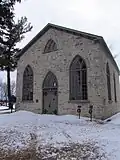
| St. Paul's Anglican Church
|
77 King Street
Rideau Lakes (Delta) ON
|
44°36′27″N 76°07′18″W / 44.6074°N 76.1217°W / 44.6074; -76.1217 (St. Paul's Anglican Church)
|
Rideau Lakes (Delta) municipality (8480)
|
|
More images
|
| St. Peter's Anglican Church
|
3600 Newboyne Road
Rideau Lakes (Newboyne) ON
|
44°44′01″N 76°06′36″W / 44.7337°N 76.1101°W / 44.7337; -76.1101 (St. Peter's Anglican Church)
|
Rideau Lakes (Newboyne) municipality (8476)
|
|
More images
|
| Storehouse, Lock Office
|
Davis Lock, Rideau Canal National Historic Site of Canada
Rideau Lakes ON
|
44°33′47″N 76°17′28″W / 44.563°N 76.291°W / 44.563; -76.291 (Storehouse, Lock Office)
|
Federal (10884)
|
|
Upload Photo
|
| Darlingside National Historic Site of Canada
|
Along the Thousands Island Parkway
Rockport ON
|
|
Federal (20125)
|
|
Upload Photo
|
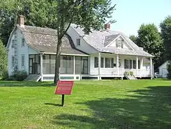
| David Laidlaw House
|
328 Centreville Road
Westport ON
|
44°40′36″N 76°23′50″W / 44.6767°N 76.3973°W / 44.6767; -76.3973 (David Laidlaw House)
|
Westport municipality (8350)
|
|
Upload Photo
|
.jpg)


.jpg)


.jpg)


.jpg)
.jpg)
.jpg)