List of crossings of the River Swale
This is a list of current bridges and other crossings of the River Swale in North Yorkshire, and are listed downstream to the river's mouth. The River Swale is listed on mapping as starting where Birkdale Beck meets Great Sleddale Beck. (SE473604).[1] The river flows for about 70 miles (110 km) before joining the River Ure near Myton-on-Swale, and then later, the Ure becomes the River Ouse.[2] The list below includes permanent bridges and crossings; structures such as the conveyor belt linking the different areas of Killerby Quarry east of Catterick village are not included. Several bridges have been removed, notably railway bridges, such as the one which used to carry the Leeds & Thirsk Railway over the river just to the north of Topcliffe.
Hoggarth's Bridge was a two-arched structure which crossed the River Swale above Wain Wath Force, and it was swept away in 1899; its replacement, High Bridge, was built slightly downstream of the predecessor.[3][4] The bridge at Gunnerside was swept away in a flood in 1890,[5] and the suspension bridge at Reeth, first installed in 1925, was swept away in flooding in the year 2000. Flash floods are known on the river with the bridge at Grinton sometimes being flooded to a depth of 18 feet (5.5 m) so that only the tops of the bridge parapets can be seen in the floodwater.[6]
As with other river locations in Northern England, especially in the old North Riding of Yorkshire, many bridges were built at the locations of fords across the river. One example of this is Scabba Wath Bridge. Wath comes from the Old Norse vað meaning ford.[7]
Crossings
| Crossing | Location | Type | Co-ordinates | Date opened | Listing[a] | Notes | Ref |
|---|---|---|---|---|---|---|---|
| Stone House Bridge | Stone House | Track | 54°23′16″N 1°49′36″W / 54.3879°N 1.8268°W | c. 1840 | II | [8][9] | |
| East Firs Bridge | East Firs | Track | 54°24′21″N 2°12′37″W / 54.4058°N 2.2103°W | c. 1840 | II | [10][9] | |
| High Bridge | Whitsun Dale | Road | 54°24′27″N 2°12′01″W / 54.4074°N 2.2004°W | c. 1900 | N/A | Hoggarth's Bridge, built c. 1790 was swept away in a flood in 1899. High Bridge was built a few years later in a position to the east of the old bridge. This is the furthest upstream public bridge on the Swale, the others being private. | [11][12] |
| Low Bridge | Keld | Road | 54°24′34″N 2°11′24″W / 54.4094°N 2.1899°W | N/A | [13] | ||
| Park Bridge | Keld | Road | 54°24′31″N 2°10′38″W / 54.4087°N 2.1773°W | N/A | [13] | ||
| Pennine Way | Keld | Foot | 54°24′17″N 2°09′42″W / 54.4048°N 2.1618°W | N/A | Up until a flood in 1899, a packhorse bridge stood on this site. | [14] | |
| Footbridge | Crackpot Hall | Foot | 54°24′01″N 2°08′50″W / 54.4004°N 2.1471°W | N/A | [13] | ||
| Rampsholme Bridge | Ivelet | Foot | 54°22′58″N 2°08′20″W / 54.3828°N 2.139°W | N/A | The older bridge here was also washed away in the 1899 flood. | [15] | |
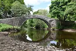
| Ivelet Bridge | Ivelet | Road | 54°22′58″N 2°08′20″W / 54.3828°N 2.139°W | Late 16th century | II* | Just to the north of the bridge is a coffin stone (a place to rest coffins) as it was on the Corpse Way between Muker and Grinton. Pevsner described it as the "..most romantic of the Swaledale bridges..." | [16][17] |
| Gunnerside Bridge | Gunnerside | Road | 54°22′58″N 2°08′20″W / 54.3828°N 2.139°W | 1892 | N/A | Several bridges have been built here, the previous bridge washed away in a flood in January 1890. | [5][18] |
| Isles Bridge | Road | 54°22′58″N 2°08′20″W / 54.3828°N 2.139°W | N/A | [13] | |||
| Scabba Wath Bridge | Low Row | Road | 54°22′58″N 2°08′20″W / 54.3828°N 2.139°W | Mid 19th century | II | [19][20] | |
| Reeth Swing Bridge | Reeth | Foot | 54°22′58″N 2°08′20″W / 54.3828°N 2.139°W | 2002 | N/A | The original structure was built in 1920; prior to this, the site was the location of stepping stones. The first bridge was swept away in a flood in September 2000, and is also known as Reeth Swing Bridge, though technically it is a suspension bridge. | [21][22] |
| Grinton Bridge | Grinton | Road (B6270) | 54°23′16″N 1°49′36″W / 54.3879°N 1.8268°W | c. 1547 | II | [23][24] | |
| Downholme Bridge | Downholme | Road | 54°23′16″N 1°49′36″W / 54.3879°N 1.8268°W | 1674 | II* | Also known as Marske New Bridge. | [25][26] |
| Lownethwaite Bridge | Road (A6108) | 54°24′05″N 1°46′34″W / 54.4014°N 1.7761°W | 1837 | N/A | [27] | ||
| Richmond Howe bridge | Richmond | Foot | 54°24′10″N 1°45′33″W / 54.4027°N 1.7593°W | N/A | [28] | ||
| Green Bridge | Richmond | Road | 54°24′02″N 1°44′25″W / 54.4005°N 1.7403°W | 1789 | II* | [29] | |
| Mercury Bridge | Richmond | Road (A6136) | 54°24′14″N 1°43′51″W / 54.4040°N 1.7308°W | 1846 | II | [30] | |
| Railway bridge | Easby | Railway | 54°23′39″N 1°43′07″W / 54.3941°N 1.7186°W | 1846 | N/A | [31] | |
| Unnamed bridge | Colburn | Foot | 54°23′32″N 1°40′56″W / 54.3922°N 1.6821°W | N/A | [32] | ||
| A1(M) bridge | Brompton-on-Swale | Road | 54°23′18″N 1°39′21″W / 54.3883°N 1.6558°W | 2018 | N/A | Replaced a structure from the original Catterick Bypass of 1959. | [33] |
| Catterick Military Railway bridge | Brough with St Giles | Foot | 54°23′20″N 1°39′11″W / 54.3890°N 1.6531°W | 1922 | N/A | Opened as a railway bridge to serve Catterick Garrison, closed in 1970, but now functions as a foot and pipeline crossing | [34] |
| Catterick Bridge | Catterick | Road (A6136) | 54°23′21″N 1°39′05″W / 54.3892°N 1.6514°W | 1422 | II* | Before the stone bridge was built, a wooden bridge was in use to the west of the current bridge. Between 1915 and 1922, the bridge carried the Great North Road and the early Catterick Military Railway. | [35][36] |
| Great Langton Bridge | Great Langton | Road | 54°21′46″N 1°33′15″W / 54.3628°N 1.5541°W | N/A | [32] | ||
| Morton railway bridge | Morton-on-Swale | Railway | 54°19′24″N 1°30′39″W / 54.3233°N 1.5107°W | 1848 | N/A | A four-span plate girder bridge on stone piers | [37] |
| Morton Bridge | Morton-on-Swale | Road (A684) | 54°19′15″N 1°30′41″W / 54.3207°N 1.5115°W | 1803 | II | [38] | |
| Railway bridge | Maunby | Railway | 54°16′12″N 1°28′05″W / 54.2700°N 1.4680°W | 1852 | N/A | Lattice girder bridge built by the Leeds Northern Railway. | [39][40] |
| Skipton Bridge | Skipton-on-Swale | Road (A61) | 54°12′45″N 1°26′37″W / 54.2125°N 1.4435°W | 1781 | II | [41] | |
| Topcliffe bridge | Topcliffe | Road (A167) | 54°10′40″N 1°23′29″W / 54.1779°N 1.3915°W | 1622 | SM | [42] | |
| Bypass bridge | Topcliffe | Road (A168) | 54°10′27″N 1°23′04″W / 54.1742°N 1.3844°W | 1977 | N/A | [43] | |
| Thornton Bridge | Thornton Bridge | Road | 54°08′12″N 1°20′20″W / 54.1367°N 1.3389°W | 1865 | II | [44][45][46] | |
| River Swale bridge | Brafferton | Railway | 54°07′37″N 1°20′17″W / 54.1270°N 1.3380°W | 1847 | N/A | Skew bridge of three arches, some 262 feet (80 m) in length. Built wide enough (23 feet 10 inches (7.26 m)) to accommodate two tracks, but only one was ever installed. Last train ran in 1964. | [47] |
| Footbridge | Brafferton | Foot | 54°07′25″N 1°20′11″W / 54.1236°N 1.3365°W | Unknown | N/A | [48] | |
| Myton Bridge | Myton-on-Swale | Road | 54°05′41″N 1°20′05″W / 54.0947°N 1.3348°W | 1868 | II | Iron single span bridge, restored in 2002. | [49] |
- ^ Either grade I, II* II, SM (scheduled monument), or N/A - not applicable
References
- ^ Hadfield, Charles (1972). The Canals of Yorkshire and North East England. Vol. 1. Newton Abbot: David & Charles. p. 93. ISBN 0-7153-5719-0.
- ^ Hatcher, Jane (2004). The History of Richmond, North Yorkshire. Pickering: Blackthorn Press. p. 4. ISBN 0-9546300-1-7.
- ^ Speight, Harry (1897). Romantic Richmondshire : Being a complete account of the history, antiquities and scenery of the picturesque valleys of the Swale and Yore. London: Elliot Stock. p. 283. OCLC 7241488.
- ^ "Side by side georeferenced maps viewer - Map images - National Library of Scotland". maps.nls.uk. Retrieved 23 April 2025.
Use the cursor to hover over the old bridge (on the left hand side mapping) to show a comparison in position with the 'newer bridge'. You can see by the wall at the top of the new bridge (at [Ordnance Survey coordinates NY8709901370]) is some distance away from the old bridge.
- ^ a b Speight, Harry (1897). Romantic Richmondshire: Being a complete account of the history, antiquities and scenery of the picturesque valleys of the Swale and Yore. London: Elliot Stock. p. 253. OCLC 7241488.
- ^ Morgan, Andrew (18 December 1999). "More quietly flows the Swale". The Times. No. 66, 701. p. 77. ISSN 0140-0460.
- ^ Smith, A. H. (1979) [1928]. The Place Names of the North Riding of Yorkshire. English Place Name Society. pp. 21, 318. OCLC 19714705.
- ^ Historic England. "Bridge Approximately 30 Metres East of Stone House (Grade II) (1131523)". National Heritage List for England. Retrieved 22 April 2025.
- ^ a b Morris 1994, p. 6.
- ^ Historic England. "Bridge Approximately 200 Metres East of Firs Farmhouse (Grade II) (1131524)". National Heritage List for England. Retrieved 22 April 2025.
- ^ Morris 1994, p. 6–8.
- ^ Pontefract & Hartley 1988, p. 30.
- ^ a b c d "OL30" (Map). Yorkshire Dales - Northern & Central Area. 1:25,000. Explorer. Ordnance Survey. 2015. ISBN 978-0-319-26335-8.
- ^ Pontefract & Hartley 1988, p. 52.
- ^ "The recent flood in Swaledale". Evening Post. No. 6, 524. 21 July 1899. p. 2. OCLC 1066535265.
- ^ Historic England. "Ivelet Bridge (Grade II*) (1179137)". National Heritage List for England. Retrieved 23 April 2025.
- ^ Hatcher 1990, p. 181.
- ^ "The gales". The Times. No. 32919. 27 January 1890. p. 7. OCLC 646880228.
- ^ Hatcher 1990, p. 109.
- ^ Historic England. "Scabba Wath Bridge (Grade II) (1130816)". National Heritage List for England. Retrieved 24 April 2025.
- ^ Pontefract & Hartley 1988, p. 133.
- ^ "New river crossing to open this week". infoweb.newsbank.com. 26 November 2002. Retrieved 24 April 2025.
- ^ Hatcher 1990, p. 104.
- ^ Historic England. "Grinton Bridge (Grade II) (1318602)". National Heritage List for England. Retrieved 19 April 2025.
- ^ Hatcher 1990, p. 71.
- ^ Historic England. "Downholme Bridge (Grade II*) (1131326)". National Heritage List for England. Retrieved 19 April 2025.
- ^ Hatcher 1990, p. 126.
- ^ "304" (Map). Darlington & Richmond. 1:25,000. Explorer. Ordnance Survey. 2015. ISBN 978-0-319-24556-9.
- ^ Historic England. "The Green Bridge (Grade II*) (1318388)". National Heritage List for England. Retrieved 8 December 2024.
- ^ Historic England. "Mercury Bridge (Grade II) (1317112)". National Heritage List for England. Retrieved 8 December 2024.
- ^ "Easby conservation area appraisal" (PDF). richmondshire.gov.uk. p. 3. Retrieved 18 April 2025.
- ^ a b "302" (Map). Northallerton & Thirsk. 1:25,000. Explorer. Ordnance Survey. 2018. ISBN 978-0-319-24554-5.
- ^ "A1 Leeming to Barton improvement scheme" (PDF). highwaysengland.co.uk. p. 21. Retrieved 18 April 2025.
- ^ "Brompton-on-Swale bridge". forgottenrelics.org. Retrieved 18 April 2025.
- ^ Historic England. "Catterick Bridge (Grade II*) (1131481)". National Heritage List for England. Retrieved 19 April 2025.
- ^ Slack, Margaret (1986). The bridges of Lancashire and Yorkshire. London: R. Hale. p. 93. ISBN 0-7090-2814-8.
- ^ Jenkins, Stanley J. (2002) [1993]. The Wensleydale Branch; a new history (2 ed.). Usk: Oakwood Press. pp. 9, 85. ISBN 0-85361-587-X.
- ^ Historic England. "Morton Bridge (Grade II) (1190515)". National Heritage List for England. Retrieved 19 April 2025.
- ^ "Country walks - following the Swale near Thirsk and Northallerton". York Press. 23 October 2021. Retrieved 21 April 2025.
- ^ "Disused Stations: Newby Wiske Station". disused-stations.org.uk. Retrieved 21 April 2025.
- ^ Historic England. "Skipton Bridge (Grade II) (1315548)". National Heritage List for England. Retrieved 21 April 2025.
- ^ "Bob Adams banishes the lockdown blues with a stroll along the River Swale". York Press. 9 May 2021. Retrieved 21 April 2025.
- ^ "Highlights of Ripon's Royal year". Ripon Gazette. 30 December 1977. p. 12. OCLC 795845522.
- ^ Pevsner, Nikolaus (1992). Yorkshire: the North Riding. London: Penguin Books. p. 369. ISBN 0140710299.
- ^ Rennison, R. W. (1996). Civil Engineering Heritage. Northern England / ed. by R. W. Rennison (2 ed.). London: Telford. p. 152. ISBN 0-7277-2518-1.
- ^ Historic England. "Thornton Bridge (Grade II) (1293791)". National Heritage List for England. Retrieved 22 April 2025.
- ^ Howat, Patrick (1991). The Pilmoor, Boroughbridge and Knaresborough railway. Halifax: Bairstow. pp. 20, 69. ISBN 1871944058.
- ^ "299" (Map). Ripon & Boroughbridge. 1:25,000. Explorer. Ordnance Survey. 2015. ISBN 978-0-319-24551-4.
- ^ Historic England. "Myton Bridge (Grade II) (1151273)". National Heritage List for England. Retrieved 22 April 2025.
Sources
- Hatcher, Jane (1990). Richmondshire architecture. Richmond: Hatcher. ISBN 0951588001.
- Jervoise, E. (1973). Ancient bridges of the North of England. East Ardsley: EP Publishing. ISBN 0-85409-952-2.
- Morris, David (1994). The Swale; a history of the holy river of St Paulinus. York: Ebor Press. ISBN 1-85072-152-1.
- Pontefract, Ella; Hartley, Marie (1988) [1934]. Swaledale. Otley: Smith Settle. ISBN 1870071190.