List of Natural Monuments of Japan (Hokkaidō)
This list is of the Natural Monuments of Japan within the Circuit of Hokkaidō.[1]
National Natural Monuments
As of 1 October 2016, forty-seven Natural Monuments have been designated, including six *Special Natural Monuments.[2][3][4][5]
.jpg)
.jpg)
.jpg)


.jpg)
.jpg)


![]() Completed
Completed
Prefectural Natural Monuments
As of 21 September 2016, thirty-three Natural Monuments have been designated at a prefectural level.[4][6][7]
| Monument | Municipality | Comments | Image | Coordinates | Type | Ref. |
|---|---|---|---|---|---|---|
| Kayabe Chestnut Forest Castanea crenata 茅部の栗林 Kayabe no kuri-bayashi |
Mori | 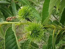 |
42°06′13″N 140°34′35″E / 42.103504°N 140.576518°E | [48] | ||
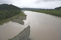
| Calcareous sinter of Futamata Onsen 二股温泉の石灰華 Futamata Onsen no sekkaika |
Oshamambe | 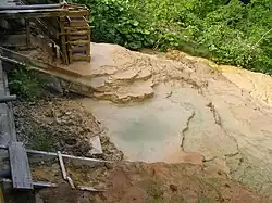 |
42°34′36″N 140°14′22″E / 42.576758°N 140.239344°E | [49] | ||
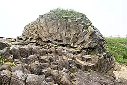
| Andesite columnar jointing of Cape Shibi, Otobe 乙部鮪ノ岬の安山岩柱状節理 Otobe Shibi-no-misaki no anzangan chūjō setsuri |
Otobe | 42°02′12″N 140°04′58″E / 42.036641°N 140.082736°E | [50] | |||
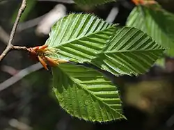
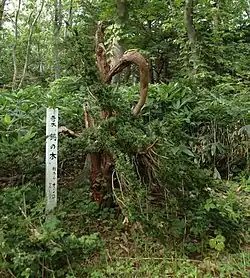
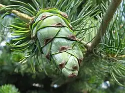
| Japanese yew of Kogane Taxus cuspidata 黄金水松 Kogane mizumatsu |
Ashibetsu | 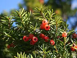 |
43°35′25″N 142°13′14″E / 43.590211°N 142.220635°E | [51] | ||
| Potholes of Sorachi Ōtaki 空知大滝甌穴群 Sorachi ōtaki ōketsugun |
Ashibetsu | 43°26′24″N 142°16′58″E / 43.439917°N 142.282848°E | [52] | |||
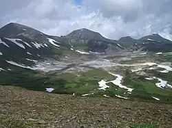
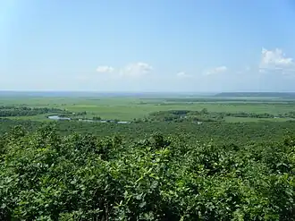
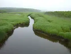
| Uryū-numa high moor belt 雨竜沼高層湿原帯 Uryū-numa kōsō shitsugen-tai |
Uryū | see Shokanbetsu-Teuri-Yagishiri Quasi-National Park, List of Ramsar sites in Japan | 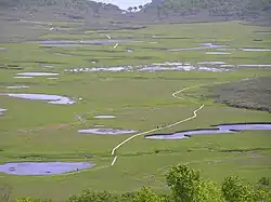 |
43°41′48″N 141°36′14″E / 43.696694°N 141.603767°E | [53] | |
| Fossil type specimen of the Takikawa sea cow タキカワカイギュウ化石標本 Takikawa-kaigyū kaseki hyōhon |
Takikawa | kept at the Takikawa Museum of Art and Natural History | 43°33′07″N 141°54′53″E / 43.552012°N 141.914647°E | [54] | ||
| Large outcrop of coal at Yūbari 夕張の石炭大露頭 Yūbari no sekitan dai-rotō |
Yūbari | see Yūbari Coal Mine Museum | 43°04′06″N 141°59′22″E / 43.068375°N 141.989402°E | [55] | ||
| Tōma Limestone Cave 当麻鍾乳洞 Tōma shōnyūdō |
Tōma | discovered in 1957; five main chambers stretch a total length of 135 metres | 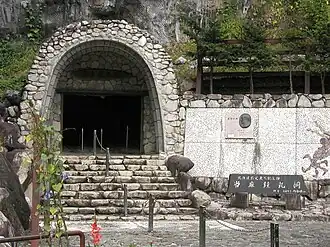 |
43°49′33″N 142°36′35″E / 43.825763°N 142.609784°E | [56] | |
| Nakatonbetsu Limestone Cave 中頓別鍾乳洞 Nakatonbetsu shōnyūdō |
Nakatonbetsu | discovered in 1933 | 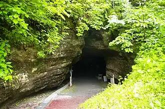 |
44°59′17″N 142°20′09″E / 44.987968°N 142.335766°E | [57] | |
| Wakasakanai coastal dune forest 稚咲内海岸砂丘林 Wakasakanai kaigan sakyū-rin |
Toyotomi | a twenty kilometre stretch of forest bordering the Sarobetsu plain and some one hundred lakes; tree species include the Yezo spruce, Japanese emperor oak, Mongolian oak, painted maple, prickly castor oil tree, and Japanese lime; the Siberian rubythroat, yellow-breasted bunting, Japanese snipe, smew, Japanese robin, and willow tit may be found within the Wildlife Protection Area | 45°05′17″N 141°38′31″E / 45.088171°N 141.642009°E | [58] | ||
| Rishiri Island Kurile cherry habitat Prunus nipponica var. kurilensis 利尻島のチシマザクラ自生地 Rishiri-tō no chishima-zakura jiseichi |
Rishiri | 45°07′35″N 141°15′02″E / 45.126394°N 141.250469°E | [59] | |||
| Wild plants around Momo-iwa, Rebun Island 礼文島桃岩付近一帯の野生植物 Rebun-tō Momo-iwa fukin ittai no yasei shokubutsu |
Rebun |  |
45°17′46″N 141°01′54″E / 45.296046°N 141.031698°E | [60] | ||
| Natural habitat of the Rebun lady's slipper orchid Cypripedium macranthum var. rebunense レブンアツモリソウ群生地 Rebun atsumorisō-gun seichi |
Rebun | 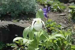 |
45°25′33″N 141°00′11″E / 45.425926°N 141.003093°E | [61] | ||
| Rhyolitic spherulites at Shirataki 白滝の流紋岩球顆 Shirataki no ryūmongan kyūka |
Engaru | 43°53′12″N 143°11′34″E / 43.886724°N 143.192785°E | [62] | |||
| Grassland communities of the Shari coast 斜里海岸の草原群落 Shari-kaigan no sōgen gunraku |
Shari | the grasslands stretch for 2.5 km to the west of the Shari River (斜里川) | 43°55′02″N 144°34′04″E / 43.917162°N 144.567780°E | [63] | ||
| Oshunkoshun dolerite columnar joints オシュンコシュン粗粒玄武岩柱状節理 Oshunkoshun soryū genbugan chūjō setsuri |
Shari | 44°02′17″N 144°56′06″E / 44.037982°N 144.934878°E | [64] | |||
| Glasswort communities of Tsuru-numa beside Lake Saroma Salicornia europaea 佐呂間湖畔鶴沼のアッケシソウ群落 Saroma kohan Tsuru-numa no akkeshisō gunraku |
Yūbetsu | 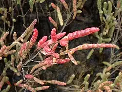 |
44°07′58″N 143°50′17″E / 44.132789°N 143.838105°E | [65] | ||
| Onneyu Rhododendron dauricum communities Rhododendron dauricum 温根湯エゾムラサキツツジ群落 Onneyu Ezo murasaki-tsutsuji gunraku |
Kitami | 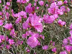 |
43°45′35″N 143°30′57″E / 43.759677°N 143.515929°E | [66] | ||
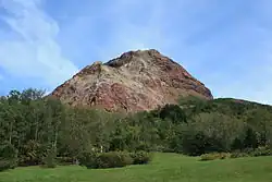
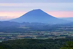
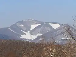
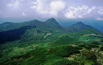
| Mount Tarumae lava dome 樽前山熔岩円頂丘 Tarumae-san yōgan enchōkyū |
Tomakomai | 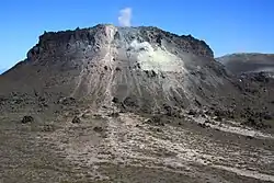 |
42°41′24″N 141°22′34″E / 42.690127°N 141.376093°E | [67] | ||
| Niikappu mud volcano 新冠泥火山 Niikappu deikazan |
Niikappu | 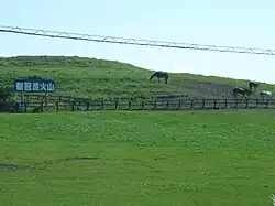 |
42°22′28″N 142°18′36″E / 42.374459°N 142.310130°E | [68] | ||
| Betula ovalifolia of Sarabetsu Marsh Betula ovalifolia 更別湿原のヤチカンバ Sarabetsu-shitsugen no yachikanba |
Sarabetsu | 42°35′47″N 143°13′52″E / 42.596405°N 143.230985°E | [69] | |||
| Lake Shikaribetsu Dolly Varden trout habitat Salvelinus malma 然別湖のオショロコマ生息地 Shikaribetsu-ko no oshorokoma seisokuchi |
Shikaoi, Kamishihoro | 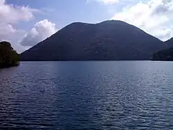 |
43°16′31″N 143°06′56″E / 43.275368°N 143.115670°E | [70] | ||
| Satsunai River basin willow habitat Salix arbutifolia 札内川流域化粧柳自生地 Satsunai-gawa ryūiki keshō-yanagi jiseichi |
Obihiro | 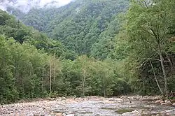 |
42°35′47″N 143°13′52″E / 42.596405°N 143.230985°E | [71] | ||
| Taishō Japanese emperor oak forest Quercus dentata 大正のカシワ林 Taishō no kashiwa-rin |
Obihiro | 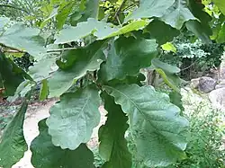 |
42°48′09″N 143°10′17″E / 42.802605°N 143.171345°E | [72] | ||
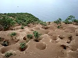
| "Tokachi-bōzu" patterned ground on the Obihiro University of Agriculture and Veterinary Medicine farm Quercus dentata 帯広畜産大学農場の構造土十勝坊主 Obihiro Chikusan Daigaku nōjō no kōzōdo Tokachi-bōzu |
Obihiro | 42°51′59″N 143°10′14″E / 42.866393°N 143.170636°E | [73] | |||
| Ōtsu coast Toitokki beach wild plant communities 大津海岸トイトツキ浜野生植物群落 Ōtsu-kaigan Toitokki-hama yasei shokubutsu gunraku |
Toyokoro | 42°42′11″N 143°39′49″E / 42.702971°N 143.663612°E | [74] | |||
| Ōtsu coast Chōbushi lakeside wild plant communities 大津海岸長節湖畔野生植物群落 Ōtsu-kaigan Chōbushi kohan yasei shokubutsu gunraku |
Toyokoro | 42°39′35″N 143°36′38″E / 42.659711°N 143.610649°E | [75] | |||
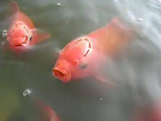
| Akkeshi Tokotan-numa Common goldfish habitat Carassius auratus 厚岸床潭沼の緋鮒生息地 Akkeshi Tokotan-numa no hibuna seisokuchi |
Akkeshi | 43°00′11″N 144°52′05″E / 43.003060°N 144.868041°E | [76] | |||
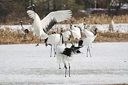
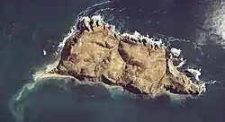
| Yururi and Moyururi Island seabird breeding grounds ユルリ・モユルリ島海鳥繁殖地 Yururi・Moyururi-tō kaichō hanshokuchi |
Nemuro | 43°13′37″N 145°36′27″E / 43.226910°N 145.607416°E | [77] | |||
| Betula ovalifolia communities of Nishibetsu Marsh Betula ovalifolia 西別湿原ヤチカンバ群落地 Nishibetsu-shitsugen yachikanba gunraku-chi |
Betsukai | 43°23′36″N 145°06′45″E / 43.393399°N 145.112541°E | [78] | |||
| Rausu luminous moss Schistostega pennata 羅臼のひかりごけ Rausu no hikarigoke |
Rausu | 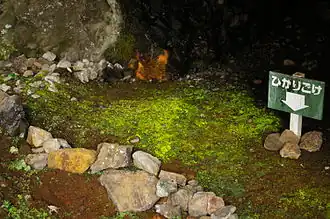 |
44°01′21″N 145°11′55″E / 44.022552°N 145.198682°E | [79] | ||
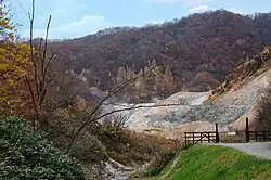
| Rausu geyser 羅臼の間歇泉 Rausu no kanketsusen |
Rausu | 44°02′01″N 145°09′34″E / 44.033478°N 145.159420°E | [80] |
![]() Completed
Completed
Municipal Natural Monuments
As of 1 May 2016, one hundred and twenty-nine Natural Monuments have been designated at a municipal level.[8][9]
| Monument | Municipality | Comments | Image | Coordinates | Type | Ref. |
|---|---|---|---|---|---|---|
| Ammonite fossils Ammonoidea アンモナイト化石(4点) Anmonaito kaseki (4-ten) |
Mikasa | four fossils; kept at Mikasa City Museum | 43°15′41″N 141°57′46″E / 43.2612604°N 141.96281101°E | for all refs see [81] | ||
| Ammonite fossil Ammonoidea アンモナイト化石 Anmonaito kaseki |
Mikasa | kept at Mikasa City Museum | 43°15′41″N 141°57′46″E / 43.2612604°N 141.96281101°E | |||
| Mammoth molar fossil Mammuthus マンモスゾウ臼歯化石 Manmosu-zō kyūshi kaseki |
Yuni | kept at Yumekukan (ゆめっく館) | 43°00′37″N 141°46′56″E / 43.010227°N 141.782132°E | |||
| Mammoth molar fossil Mammuthus マンモスゾウ臼歯化石 Manmosu-zō kyūshi kaseki |
Yuni | kept at Yumekukan (ゆめっく館) | 43°00′37″N 141°46′56″E / 43.010227°N 141.782132°E | |||
| Megaloceros fossil Megaloceros オオツノシカ化石 Ōtsuno-shika kaseki |
Yuni | kept at Yumekukan (ゆめっく館) | 43°00′37″N 141°46′56″E / 43.010227°N 141.782132°E | |||
| Bison fossil Bison バイソン(Bison.sp)の化石 Baison no kaseki |
Kitahiroshima | kept at Kitahiroshima East Memorial Hall (北広島東記念館) | 42°59′15″N 141°34′23″E / 42.987447°N 141.572982°E | |||
| Gome Island, Otoshibe 音標のゴメ島 Otoshibe no Gome-jima |
Esashi | 44°42′03″N 142°49′54″E / 44.700833°N 142.831667°E | ||||
| Ezo salamander habitat Hynobius retardatus エゾサンショーウオ生息地 Ezo sanshōō seisokuchi |
Esashi | 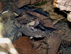 |
45°01′51″N 142°30′35″E / 45.030776°N 142.509839°E | |||
| Siberian salamander Salamandrella keyserlingii キタサンショウウオ Kita-sanshōō |
Shibecha |
| Tangible Cultural Properties |    | |
|---|---|---|
| Intangible Cultural Properties |
| |
| Folk Cultural Properties |
| |
| Monuments | ||
| Cultural Landscapes | Cultural Landscape along the Saru River resulting from Ainu Tradition and Modern Settlement | |
| Groups of Traditional Buildings |
| |
| Conservation Techniques | N/A | |
1 | ||
See also
- Cultural Properties of Japan
- List of parks and gardens of Hokkaido
- List of Places of Scenic Beauty of Japan (Hokkaido)
- List of Natural Monuments of Japan (Okinawa)
References
- ^ "Cultural Properties for Future Generations". Agency for Cultural Affairs. Retrieved 4 October 2016.
- ^ 史跡名勝天然記念物 [Number of Monuments of Japan by Prefecture] (in Japanese). Agency for Cultural Affairs. 1 October 2016. Retrieved 4 October 2016.
- ^ "Database of National Cultural Properties: 史跡名勝天然記念物 (特別天然記念物, 天然記念物 北海道)" (in Japanese). Agency for Cultural Affairs. Archived from the original on 2 May 2017. Retrieved 4 October 2016.
- ^ a b 北海道の指定文化財件数一覧 [Number of Cultural Properties of Hokkaido] (in Japanese). Hokkaido Government Board of Education. 17 August 2016. Retrieved 4 October 2016.
- ^ 国の指定・選定文化財一覧 [List of National Cultural Properties] (in Japanese). Hokkaido Government Board of Education. 29 August 2016. Retrieved 4 October 2016.
- ^ 都道府県別指定等文化財件数(都道府県分) [Number of Prefectural Cultural Properties by Prefecture] (in Japanese). Agency for Cultural Affairs. 1 May 2016. Retrieved 4 October 2016.
- ^ 北海道指定の文化財一覧 [List of Hokkaido Prefectural Cultural Properties] (in Japanese). Hokkaido Government Board of Education. 21 September 2016. Retrieved 4 October 2016.
- ^ 都道府県別指定等文化財件数(市町村分) [Number of Municipal Cultural Properties by Prefecture] (in Japanese). Agency for Cultural Affairs. 1 May 2016. Retrieved 4 October 2016.
- ^ 市町村指定文化財一覧 [List of Municipal Cultural Properties] (in Japanese). Hokkaido Government Board of Education. 1 May 2016. Retrieved 4 October 2016.
External links
- (in Japanese) Cultural Properties in Hokkaido