Liberal, Indiana
Liberal, Indiana | |
|---|---|
 Liberal  Liberal | |
| Coordinates: 38°02′45″N 86°56′35″W / 38.04583°N 86.94306°W | |
| Country | United States |
| State | Indiana |
| County | Spencer |
| Township | Clay |
| Elevation | 433 ft (132 m) |
| Time zone | UTC-6 (Central (CST)) |
| • Summer (DST) | UTC-5 (CDT) |
| ZIP code | 47550 |
| Area codes | 812, 930 |
| GNIS feature ID | 437815 |
Liberal is an unincorporated community in Clay Township, Spencer County, in the U.S. state of Indiana.[2]
History
A post office was established at Liberal in 1887, and remained in operation until it was discontinued in 1907.[3]
Geography
Liberal is located at 38°02′45″N 86°56′35″W / 38.04583°N 86.94306°W.
References
- ^ "US Board on Geographic Names". United States Geological Survey. October 25, 2007. Retrieved July 9, 2016.
- ^ "Liberal, Indiana". Geographic Names Information System. United States Geological Survey, United States Department of the Interior. Retrieved July 9, 2016.
- ^ "Spencer County". Jim Forte Postal History. Retrieved October 4, 2015.
Municipalities and communities of Spencer County, Indiana, United States | ||
|---|---|---|
| City | 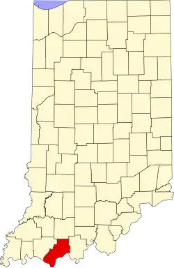 | |
| Towns | ||
| Townships | ||
| CDPs | ||
| Other communities | ||