Lehigh Township, Marion County, Kansas
Lehigh Township Marion County, Kansas | |
|---|---|
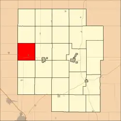 Location within Marion County | |
 Lehigh Township Marion County, Kansas Location within the state of Kansas | |
| Coordinates: 38°23′29″N 97°19′00″W / 38.3914905°N 97.3165415°W[1] | |
| Country | United States |
| State | Kansas |
| County | Marion |
| Area | |
• Total | 36 sq mi (90 km2) |
| Dimensions | |
| • Length | 6.0 mi (9.7 km) |
| • Width | 6.0 mi (9.7 km) |
| Elevation | 1,562 ft (476 m) |
| Population | |
• Total | 329 |
| • Density | 9.1/sq mi (3.5/km2) |
| Time zone | UTC-6 (CST) |
| • Summer (DST) | UTC-5 (CDT) |
| Area code | 620 |
| FIPS code | 20-39250 [1] |
| GNIS ID | 477225 [1] |
| Website | County website |
Lehigh Township is a township in Marion County, Kansas, United States.[1] As of the 2010 census, the township population was 329, including the city of Lehigh.[2]
Geography
Lehigh Township covers an area of 36 square miles (93.2 km2).
Communities
The township contains the following settlements:
Cemeteries
The township contains the following cemeteries:
- Lehigh Mennonite Cemetery, located in Section 27 T19S R1E.[3]
- Lehigh Township Cemetery (aka Dalke Cemetery), located in Section 21 T19S R1E.[3]
- Mennonite Brethren Church Cemetery, located in Section 27 T19S R1E.[3]
- Silberfeld Community Cemetery (no longer in use), located in Section 1 T19S R1E.[3]
Transportation
K-15 and U.S. Route 56 highways pass through the township.[4]
References
- ^ a b c d e "Lehigh Township, Marion County, Kansas", Geographic Names Information System, United States Geological Survey, United States Department of the Interior
- ^ a b "2010 Total Population - Township of Lehigh". U.S. Census Bureau. Archived from the original on February 12, 2020. Retrieved June 17, 2013.
- ^ a b c d Marion County Cemetery List. Archived 2013-05-09 at the Wayback Machine
- ^ "Marion County Highway Map; KSDOT" (PDF). Archived from the original (PDF) on October 2, 2021. Retrieved June 17, 2013.
Further reading
External links
Places adjacent to Lehigh Township, Marion County, Kansas | |
|---|---|
Municipalities and communities of Marion County, Kansas, United States | ||
|---|---|---|
| Cities | 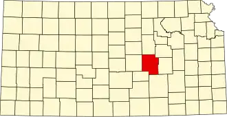 | |
| CDPs | ||
| Unincorporated communities | ||
| Ghost towns | ||
| Townships | ||
| Footnotes | ‡This community also has portions in an adjacent county or counties. | |