Koursibo
| Koursibo | |
|---|---|
 | |
 | |
| Location | |
| Country | French Guiana |
| Physical characteristics | |
| Source | |
| • location | French Guiana |
| • coordinates | 3°54′41″N 53°09′19″W / 3.9113°N 53.1554°W |
| Mouth | |
• location | Sinnamary |
• coordinates | 4°55′25″N 53°00′51″W / 4.9236°N 53.0141°W |
| Length | 135 km (84 mi) |
| Basin features | |
| Progression | Sinnamary→ Atlantic Ocean |
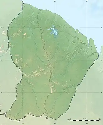
The Koursibo is a 135 km long river in French Guiana.[1] It rises in the centre of the country, flowing north until it reaches the river Sinnamary. Its eventual outflow is into the Atlantic Ocean.
References