Klemtu
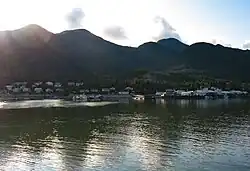
Klemtu is an unincorporated community on Swindle Island in the coastal fjords of British Columbia, Canada. It is located on Kitasoo Indian Reserve No. 1.[1]
Klemtu is the home of the Kitasoo tribe of Tsimshians, originally from Kitasu Bay, and the Xai'xais of Kynoch Inlet,[2] extends eastward from Queen Charlotte Sound, approximately at 52°46′03″N 128°06′25″W / 52.767462°N 128.10688°W. It is adjacent to the Fiordland Conservancy. These two tribes live together as, and are jointly governed by, the Kitasoo/Xai'xais Nation. Traditional languages spoken at Klemtu are the southern dialect of the Tsimshian language, called Southern Tsimshian, and Xaixais, a dialect of the Heiltsuk language. In religious affiliation, the community is dominated by the United Church of Canada.
The government of the Kitasoo/Xai'xais Nation is a member government of the Wuikinuxv-Kitasoo Xai’xais-Nuxalk Tribal Council.
The population of Klemtu in 1983 was 269. As of 2007 the population of Klemtu was 505.
Name origin
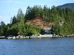
An alternate older name for Klemtu is Kitasoo.[3] it was also known as China Hat due to the shape of Cone Island, which protects it from the open water. The name Klemtu is from the Coast Tsimshian language "Klemdoo-oolk," meaning "impassable".[4]
Climate
| Climate data for Boat Bluff[a] (1981–2010) | |||||||||||||
|---|---|---|---|---|---|---|---|---|---|---|---|---|---|
| Month | Jan | Feb | Mar | Apr | May | Jun | Jul | Aug | Sep | Oct | Nov | Dec | Year |
| Record high humidex | 15.1 | 12.2 | 17.6 | 21.1 | 27.5 | 30.1 | 36.2 | 30.5 | 27.9 | 23.4 | 13.3 | 12.0 | 36.2 |
| Record high °C (°F) | 18.0 (64.4) |
17.0 (62.6) |
20.0 (68.0) |
25.5 (77.9) |
31.5 (88.7) |
33.5 (92.3) |
32.5 (90.5) |
33.0 (91.4) |
30.0 (86.0) |
21.0 (69.8) |
16.5 (61.7) |
15.5 (59.9) |
33.5 (92.3) |
| Mean daily maximum °C (°F) | 6.0 (42.8) |
6.6 (43.9) |
8.3 (46.9) |
10.9 (51.6) |
14.1 (57.4) |
16.6 (61.9) |
18.7 (65.7) |
19.0 (66.2) |
16.2 (61.2) |
11.7 (53.1) |
7.6 (45.7) |
5.8 (42.4) |
11.8 (53.2) |
| Daily mean °C (°F) | 3.6 (38.5) |
3.9 (39.0) |
5.3 (41.5) |
7.4 (45.3) |
10.4 (50.7) |
12.9 (55.2) |
14.7 (58.5) |
15.1 (59.2) |
12.8 (55.0) |
9.0 (48.2) |
5.2 (41.4) |
3.6 (38.5) |
8.7 (47.6) |
| Mean daily minimum °C (°F) | 1.2 (34.2) |
1.2 (34.2) |
2.2 (36.0) |
3.9 (39.0) |
6.6 (43.9) |
9.0 (48.2) |
10.8 (51.4) |
11.1 (52.0) |
9.4 (48.9) |
6.4 (43.5) |
2.9 (37.2) |
1.4 (34.5) |
5.5 (41.9) |
| Record low °C (°F) | −16.0 (3.2) |
−17.5 (0.5) |
−14.0 (6.8) |
−1.0 (30.2) |
−1.0 (30.2) |
4.0 (39.2) |
5.5 (41.9) |
6.5 (43.7) |
4.0 (39.2) |
−7.6 (18.3) |
−20.2 (−4.4) |
−14.0 (6.8) |
−20.2 (−4.4) |
| Record low wind chill | −18 | −15 | −10 | 0 | 0 | 0 | 0 | 0 | 0 | 0 | −11 | −21 | −21 |
| Average precipitation mm (inches) | 601.9 (23.70) |
428.5 (16.87) |
428.4 (16.87) |
389.1 (15.32) |
257.7 (10.15) |
226.2 (8.91) |
179.8 (7.08) |
231.4 (9.11) |
366.0 (14.41) |
631.8 (24.87) |
677.8 (26.69) |
628.1 (24.73) |
5,046.7 (198.71) |
| Average rainfall mm (inches) | 574.5 (22.62) |
400.3 (15.76) |
414.6 (16.32) |
386.9 (15.23) |
257.7 (10.15) |
226.2 (8.91) |
179.8 (7.08) |
231.4 (9.11) |
366.0 (14.41) |
630.0 (24.80) |
670.1 (26.38) |
606.2 (23.87) |
4,943.7 (194.64) |
| Average snowfall cm (inches) | 27.4 (10.8) |
28.3 (11.1) |
13.9 (5.5) |
2.3 (0.9) |
0.0 (0.0) |
0.0 (0.0) |
0.0 (0.0) |
0.0 (0.0) |
0.0 (0.0) |
1.9 (0.7) |
7.6 (3.0) |
21.9 (8.6) |
103.3 (40.6) |
| Average precipitation days (≥ 0.2 mm) | 23.3 | 19.6 | 22.9 | 21.4 | 19.7 | 17.8 | 16.7 | 17.4 | 19.4 | 24.7 | 24.9 | 24.9 | 252.7 |
| Average snowy days (≥ 0.2 cm) | 4.0 | 3.7 | 3.3 | 1.0 | 0.0 | 0.0 | 0.0 | 0.0 | 0.0 | 0.3 | 2.0 | 4.2 | 18.5 |
| Source: Environment Canada[5] | |||||||||||||
See also
Notes
- ^ Boat Bluff is located approximately 6 kilometres (3.7 mi) north of Klemtu.
References
- ^ "Klemtu". BC Geographical Names.
- ^ Kynoch Inlet
- ^ "Kitasoo". BC Geographical Names.
- ^ "Klemtu". BC Geographical Names.
- ^ "Canadian Climate Normals 1981-2010 Station Data". September 25, 2013. Retrieved April 11, 2020.
External links
Bibliography
- Inglis, Gordon B., et al. (1990) "Tsimshians of British Columbia since 1900." In Handbook of North American Indians, Volume 7: Northwest Coast, pp. 285–293. Washington: Smithsonian Institution.
- Miller, Jay (1981) "Moieties and Cultural Amnesia: Manipulation of Knowledge in a Pacific Northwest Coast Native Community," Arctic Anthropology, vol. 18, no. 1, pp. 23–32.
- Miller, Jay (1982) "Tsimshian Moieties and Other Clarifications," Northwest Anthropological Research Notes, vol. 16, no. 2, pp. 148–164.