King Ranch Colony, Montana
King Ranch Colony, Montana | |
|---|---|
 King Ranch Colony  King Ranch Colony | |
| Coordinates: 47°03′34″N 109°37′47″W / 47.05944°N 109.62972°W | |
| Country | United States |
| State | Montana |
| County | Fergus |
| Area | |
• Total | 1.11 sq mi (2.87 km2) |
| • Land | 1.11 sq mi (2.87 km2) |
| • Water | 0.00 sq mi (0.00 km2) |
| Elevation | 3,920 ft (1,190 m) |
| Population (2020) | |
• Total | 57 |
| • Density | 51.35/sq mi (19.83/km2) |
| Time zone | UTC-7 (Mountain (MST)) |
| • Summer (DST) | UTC-6 (MDT) |
| ZIP Code | 59457 (Lewistown) |
| Area code | 406 |
| FIPS code | 30-40718 |
| GNIS feature ID | 2804290[2] |
King Ranch Colony is a Hutterite community[3] and census-designated place (CDP) in Fergus County, Montana, United States. It is in the western part of the county, 3 miles (5 km) northwest of U.S. Routes 87/191 and 11 miles (18 km) west of Lewistown, the county seat.
The community was first listed as a CDP prior to the 2020 census.[2]
Demographics
| Census | Pop. | Note | %± |
|---|---|---|---|
| 2020 | 57 | — | |
| U.S. Decennial Census[4] | |||
References
- ^ "ArcGIS REST Services Directory". United States Census Bureau. Retrieved September 5, 2022.
- ^ a b c U.S. Geological Survey Geographic Names Information System: King Ranch Colony, Montana
- ^ Morton, Claudette, ed. (2010). Essential Understandings of Montana Hutterites: A Resource for Educators and Students (PDF). Montana Office of Public Instruction. p. 2. Archived from the original (PDF) on June 9, 2021. Retrieved June 9, 2021.
- ^ "Census of Population and Housing". Census.gov. Retrieved June 4, 2016.
Municipalities and communities of Fergus County, Montana, United States | ||
|---|---|---|
| City | 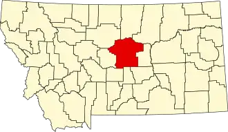 | |
| Towns | ||
| CDPs | ||
| Other communities | ||
| Ghost town | ||
| Indian reservation | ||
| Footnotes | ‡This populated place also has portions in an adjacent county or counties | |