Khotsimsk district
Khotsimsk district
| |
|---|---|
 Flag  Coat of arms | |
 | |
| Country | Belarus |
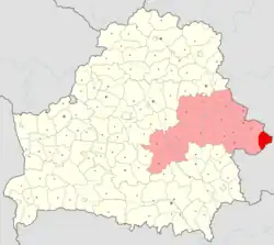
| Region | Mogilev region |
| Administrative center | Khotsimsk |
| Area | |
• Total | 858.87 km2 (331.61 sq mi) |
| Population (2023)[1] | |
• Total | 9,877 |
| • Density | 11/km2 (30/sq mi) |
| Time zone | UTC+3 (MSK) |
Khotsimsk district or Chocimsk district[2] (Belarusian: Хоцімскі раён; Russian: Хотимский район, romanized: Khotimsky rayon) is a district (raion) of Mogilev region in Belarus. The administrative center is the urban-type settlement of Khotsimsk. As of 2009, its population was 13,057. The population of Khotsimsk accounts for 54.3% of the district's population.[3]
Khotimsk district is the easternmost district of the country. The extreme eastern point of Belarus lies to the east of Khotsimsk.[4]
References
- ^ "Численность населения на 1 января 2023 г. и среднегодовая численность населения за 2022 год по Республике Беларусь в разрезе областей, районов, городов, поселков городского типа". belsat.gov.by. Archived from the original on 17 April 2023. Retrieved 5 August 2023.
- ^ Official transliteration from Belarusian language (2007)
- ^ Численность населения областей и районов: Могилевская (PDF) (in Russian). Национальный статистический комитет Республики Беларусь. Archived from the original (PDF) on 18 September 2010. Retrieved 30 January 2012.
- ^ "Coordinates of the extreme points of the state frontier. Main Geographic Characteristics of the Republic of Belarus". Land of Ancestors. 2011. Archived from the original on 21 September 2013. Retrieved 9 September 2013.
53°24′30″N 32°34′20″E / 53.40833°N 32.57222°E