Kedron, Louisiana
Kedron, Louisiana | |
|---|---|
 Kedron, Louisiana  Kedron, Louisiana | |
| Coordinates: 30°45′24″N 90°34′38″W / 30.75667°N 90.57722°W | |
| Country | United States |
| State | Louisiana |
| Parish | St. Helena Parish |
| Elevation | 148 ft (45 m) |
| Time zone | UTC-6 (Central (CST)) |
| • Summer (DST) | UTC-5 (CDT) |
| ZIP code | 70422 |
| Area code | 225 985 |
| GNIS feature ID | 1629287[1] |
| FIPS code | 22-39125 |
Kedron is an unincorporated community in St. Helena Parish, Louisiana, United States. The community is located less than 4 miles (6.4 kilometres) northwest of Amite City and 3 miles (4.8 kilometres) west of Roseland.[2][3]
References
- ^ a b U.S. Geological Survey Geographic Names Information System: Kedron, Louisiana
- ^ Thomas G. Shanks (1984). The American atlas: US latitudes and longitudes, time changes, and time zones. ACS Publications. p. 359. ISBN 978-0-917086-16-8.
- ^ Alcée Fortier (1914). Louisiana: Comprising Sketches of Parishes, Towns, Events, Institutions, and Persons, Arranged in Cyclopedic Form. Century historical association. pp. 604–.
Municipalities and communities of St. Helena Parish, Louisiana, United States | ||
|---|---|---|
| Town | 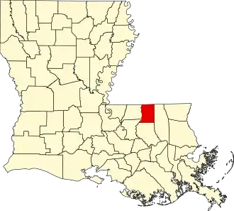 | |
| Village | ||
| Unincorporated communities | ||