Kalewa
Kalewa | |
|---|---|
Town | |
 | |
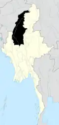
 Kalewa Location of Kalewa within Myanmar | |
| Coordinates: 23°12′48″N 94°19′06″E / 23.21333°N 94.31833°E | |
| Country | |
| Division | |
| District | Kale |
| Township | Kale Township |
| Time zone | UTC+06:30 (MST) |
Kalewa is a town at the confluence of the Chindwin River and the Myittha River in Kale District, Sagaing Region of north-western Myanmar. It is the administrative seat of Kalewa Township.
Climate
Kalewa has a tropical savanna climate (Köppen climate classification Aw). Temperatures are very warm throughout the year, although the winter months (December–February) are milder. The pre-monsoon months from March to May are especially hot, with maximum temperatures around 35 °C (95 °F). There is a winter dry season (November–April) and a summer wet season (May–October).
| Climate data for Kalewa (1981–2010) | |||||||||||||
|---|---|---|---|---|---|---|---|---|---|---|---|---|---|
| Month | Jan | Feb | Mar | Apr | May | Jun | Jul | Aug | Sep | Oct | Nov | Dec | Year |
| Record high °C (°F) | 30.8 (87.4) |
37.2 (99.0) |
41.8 (107.2) |
43.4 (110.1) |
45.0 (113.0) |
42.8 (109.0) |
38.9 (102.0) |
37.2 (99.0) |
35.6 (96.1) |
35.1 (95.2) |
32.8 (91.0) |
30.1 (86.2) |
45.0 (113.0) |
| Mean daily maximum °C (°F) | 25.6 (78.1) |
29.2 (84.6) |
33.9 (93.0) |
36.5 (97.7) |
35.7 (96.3) |
32.9 (91.2) |
32.5 (90.5) |
31.9 (89.4) |
31.5 (88.7) |
30.9 (87.6) |
27.9 (82.2) |
25.0 (77.0) |
31.1 (88.0) |
| Mean daily minimum °C (°F) | 13.3 (55.9) |
14.4 (57.9) |
17.9 (64.2) |
22.1 (71.8) |
24.2 (75.6) |
25.0 (77.0) |
25.0 (77.0) |
24.8 (76.6) |
24.1 (75.4) |
22.9 (73.2) |
19.1 (66.4) |
14.9 (58.8) |
20.6 (69.1) |
| Record low °C (°F) | 9.4 (48.9) |
9.5 (49.1) |
10.0 (50.0) |
15.6 (60.1) |
15.5 (59.9) |
21.8 (71.2) |
22.4 (72.3) |
20.8 (69.4) |
21.5 (70.7) |
18.6 (65.5) |
13.4 (56.1) |
10.7 (51.3) |
9.4 (48.9) |
| Average rainfall mm (inches) | 2.9 (0.11) |
4.0 (0.16) |
17.3 (0.68) |
37.6 (1.48) |
182.0 (7.17) |
272.1 (10.71) |
245.6 (9.67) |
303.3 (11.94) |
346.3 (13.63) |
187.5 (7.38) |
38.7 (1.52) |
4.0 (0.16) |
1,641.3 (64.62) |
| Source: Norwegian Meteorological Institute[1] | |||||||||||||
Economy
Upstream from Mandalay and Monywa on the Chindwin River, Kalewa is gaining importance as a staging point for trade between Burma and India.

See also
References
- ^ "Myanmar Climate Report" (PDF). Norwegian Meteorological Institute. pp. 23–36. Archived from the original (PDF) on 8 October 2018. Retrieved 28 October 2018.
See also
- Chaube, S.K. 1999. Hill Politics in North-east India. Patna: Orient Longman.
- Lalsiampuii, s. 1997. Mizoram. New Delhi: Ministry of Information and Broadcasting. Govt. of India.
- Johnny, N.E. 1991. Lushai custom; A monograph on Lushai customs and ceremonies. Aizawl: Tribal Research Institute.
- Tribal Research Institute. 1991. Tribal Research Institute, Directorate of Art and Culture.
- Tribal Research. 1980. The Tribes of Mizos. (A Dissertation): Tribal Research Institute.
- "The Lost Tribes of Israel", Tudor Parfitt, Phoenix, 2002. ISBN 1-84212-665-2
Wikimedia Commons has media related to Kalewa.
.svg.png)