Křenek
Křenek | |
|---|---|
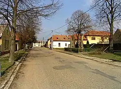 Western part of Křenek | |
 Flag 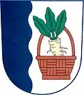 Coat of arms | |
 Křenek Location in the Czech Republic | |
| Coordinates: 50°13′47″N 14°37′46″E / 50.22972°N 14.62944°E | |
| Country | |
| Region | Central Bohemian |
| District | Prague-East |
| First mentioned | 1271 |
| Area | |
• Total | 5.29 km2 (2.04 sq mi) |
| Elevation | 165 m (541 ft) |
| Population (2025-01-01)[1] | |
• Total | 324 |
| • Density | 61/km2 (160/sq mi) |
| Time zone | UTC+1 (CET) |
| • Summer (DST) | UTC+2 (CEST) |
| Postal code | 277 14 |
| Website | www |
Křenek is a municipality and village in Prague-East District in the Central Bohemian Region of the Czech Republic. It has about 300 inhabitants.
Demographics
| Year | Pop. | ±% |
|---|---|---|
| 1869 | 338 | — |
| 1880 | 328 | −3.0% |
| 1890 | 316 | −3.7% |
| 1900 | 326 | +3.2% |
| 1910 | 398 | +22.1% |
| 1921 | 393 | −1.3% |
| 1930 | 369 | −6.1% |
| 1950 | 336 | −8.9% |
| 1961 | 323 | −3.9% |
| 1970 | 293 | −9.3% |
| 1980 | 254 | −13.3% |
| 1991 | 223 | −12.2% |
| 2001 | 218 | −2.2% |
| 2011 | 241 | +10.6% |
| 2021 | 306 | +27.0% |
| Source: Censuses[2][3] | ||
References
- ^ "Population of Municipalities – 1 January 2025". Czech Statistical Office. 2025-05-16.
- ^ "Historický lexikon obcí České republiky 1869–2011" (in Czech). Czech Statistical Office. 2015-12-21.
- ^ "Population Census 2021: Population by sex". Public Database. Czech Statistical Office. 2021-03-27.
External links
Wikimedia Commons has media related to Křenek.