Jovista, California
Jovista, California | |
|---|---|
 Jovista  Jovista | |
| Coordinates: 35°47′38″N 119°11′22″W / 35.79389°N 119.18944°W | |
| Country | |
| State | |
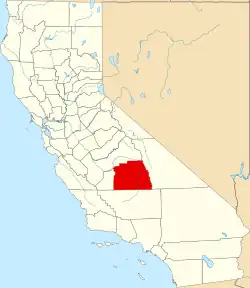
| County | Tulare |
| Area | |
• Total | 0.26 km2 (0.10 sq mi) |
| • Land | 0.26 km2 (0.10 sq mi) |
| • Water | 0.0 km2 (0.0 sq mi) |
| Elevation | 120 m (395 ft) |
| Population (2020) | |
• Total | 41 |
| Time zone | UTC-8 (Pacific (PST)) |
| • Summer (DST) | UTC-7 (PDT) |
| ZIP Code | 93215 (Delano) |
| Area code | 559 |
| FIPS code | 06-37568 |
| GNIS feature ID | 2805908[2] |
Jovista is an unincorporated community and census-designated place (CDP) in Tulare County, California, United States. It is on the southern border of the county, 5 miles (8 km) northeast of Delano, a city in Kern County. Jovista was first listed as a CDP prior to the 2020 census. It had a population of 41 at the 2020 census.
Demographics
| Census | Pop. | Note | %± |
|---|---|---|---|
| 2020 | 41 | — | |
| U.S. Decennial Census[3] 1850–1870[4][5] 1880-1890[6] 1900[7] 1910[8] 1920[9] 1930[10] 1940[11] 1950[12] 1960[13] 1970[14] 1980[15] 1990[16] 2000[17] 2010[18] 2020[19] | |||
Jovista first appeared as a census designated place in the 2020 U.S. Census.[20]
2020 Census
| Race / Ethnicity (NH = Non-Hispanic) | Pop 2020[19] | % 2020 |
|---|---|---|
| White alone (NH) | 1 | 2.44% |
| Black or African American alone (NH) | 0 | 0.00% |
| Native American or Alaska Native alone (NH) | 0 | 0.00% |
| Asian alone (NH) | 0 | 0.00% |
| Pacific Islander alone (NH) | 0 | 0.00% |
| Other race alone (NH) | 0 | 0.00% |
| Mixed race or Multiracial (NH) | 0 | 0.00% |
| Hispanic or Latino (any race) | 40 | 97.56% |
| Total | 41 | 100.00% |
References
- ^ "2020 U.S. Gazetteer Files – California". United States Census Bureau. Retrieved April 1, 2021.
- ^ a b "Jovista Census Designated Place". Geographic Names Information System. United States Geological Survey, United States Department of the Interior.
- ^ "Decennial Census by Decade". US Census Bureau.
- ^ "1870 Census of Population - Population of Civil Divisions less than Counties - California - Almeda County to Sutter County" (PDF). United States Census Bureau.
- ^ "1870 Census of Population - Population of Civil Divisions less than Counties - California - Tehama County to Yuba County" (PDF). United States Census Bureau.
- ^ "1890 Census of Population - Population of California by Minor Civil Divisions" (PDF). United States Census Bureau.
- ^ "1900 Census of Population - Population of California by Counties and Minor Civil Divisions" (PDF). United States Census Bureau.
- ^ "1910 Census of Population - Supplement for California" (PDF). United States Census Bureau.
- ^ "1920 Census of Population - Number of Inhabitants - California" (PDF). United States Census Bureau.
- ^ "1930 Census of Population - Number and Distribution of Inhabitants - California" (PDF). United States Census Bureau.
- ^ "1940 Census of Population - Number of Inhabitants - California" (PDF). United States Census Bureau.
- ^ "1950 Census of Population - Number of Inhabitants - California" (PDF). United States Census Bureau.
- ^ "1960 Census of Population - General population Characteristics - California" (PDF). United States Census Bureau.
- ^ "1970 Census of Population - Number of Inhabitants - California" (PDF). United States Census Bureau.
- ^ "1980 Census of Population - Number of Inhabitants - California" (PDF). United States Census Bureau.
- ^ "1990 Census of Population - Population and Housing Unit Counts - California" (PDF). United States Census Bureau.
- ^ "2000 Census of Population - Population and Housing Unit Counts - California" (PDF). United States Census Bureau.
- ^ "2010 Census of Population - Population and Housing Unit Counts - California" (PDF). United States Census Bureau.
- ^ a b "P2: Hispanic or Latino, and Not Hispanic or Latino by Race – 2020: DEC Redistricting Data (PL 94-171) – Jovista CDP, California". United States Census Bureau.
- ^ "2020 Geography Changes". United States Census Bureau.