Jerer River
| Jerer River | |
|---|---|
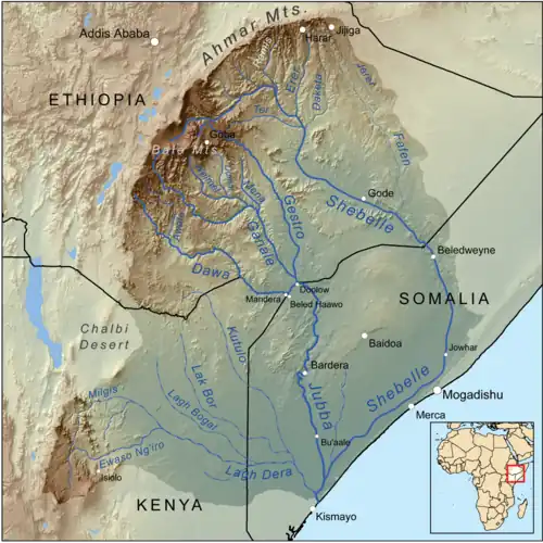 Map of the Jubba River Basin, showing the Jerer in the upper right | |
| Location | |
| Country | Ethiopia |
| Regions | Somali, Oromia |
| Physical characteristics | |
| Source | Ethiopian Highlands |
| • location | Near Chinaksen |
| • coordinates | 9°31′43″N 42°34′28″E / 9.52861°N 42.57444°E |
| • elevation | 2,505 m (8,219 ft) |
| Mouth | Fafen River |
• coordinates | 7°39′27″N 43°48′12″E / 7.657486°N 43.803253°E |
• elevation | 777 m (2,549 ft) |
| Length | 309 km (192 mi)[1] |
| Basin size | 10,628 km2 (4,103 sq mi)[1] |
| Discharge | |
| • location | Mouth[1] |
| • average | 5.22 m3/s (184 cu ft/s) |
| • minimum | 0 m3/s (0 cu ft/s) |
| • maximum | 20.2 m3/s (710 cu ft/s) |
| Basin features | |
| Progression | Fafen → Shebelle → Jubba → Somali Sea |
| River system | Jubba Basin |
| Cities | Jijiga |
| Population | 579,000[2] |
The Jerer is an intermittent stream of eastern Ethiopia. A tributary of the Fafen River, it rises near Jijiga to flow in a south-easterly direction.
References
- ^ a b c Lehner, Bernhard; Verdin, Kristine; Jarvis, Andy (2008-03-04). "New Global Hydrography Derived From Spaceborne Elevation Data". Eos, Transactions American Geophysical Union. 89 (10): 93–94. doi:10.1029/2008eo100001. ISSN 0096-3941.
- ^ Liu, L., Cao, X., Li, S., & Jie, N. (2023). GlobPOP: A 31-year (1990-2020) global gridded population dataset generated by cluster analysis and statistical learning (1.0) [Data set]. Zenodo. https://doi.org/10.5281/zenodo.10088105