Jenningston, West Virginia
Jenningston, West Virginia | |
|---|---|
 Jenningston, West Virginia  Jenningston, West Virginia | |
| Coordinates: 38°59′17″N 79°31′50″W / 38.98806°N 79.53056°W | |
| Country | United States |
| State | West Virginia |
| County | Tucker |
| Elevation | 2,037 ft (621 m) |
| Time zone | UTC-5 (Eastern (EST)) |
| • Summer (DST) | UTC-4 (EDT) |
| Area codes | 304 & 681 |
| GNIS feature ID | 1554803[1] |
Jenningston is an unincorporated community in Tucker County, West Virginia, United States. Jenningston is located on the Dry Fork, 11 miles (18 km) southeast of Parsons.[2]
References
- ^ "Jenningston". Geographic Names Information System. United States Geological Survey, United States Department of the Interior.
- ^ Tucker County, West Virginia General Highway Map (PDF) (Map). West Virginia Department of Transportation. 2011. p. 2. Retrieved March 20, 2012.
Municipalities and communities of Tucker County, West Virginia, United States | ||
|---|---|---|
| Cities | 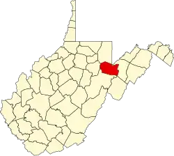 | |
| Towns | ||
| CDP | ||
| Other communities | ||
| Ghost towns | ||