Janesville, Illinois
Janesville, Illinois | |
|---|---|
 Janesville, Illinois  Janesville, Illinois | |
| Coordinates: 39°22′29″N 88°14′43″W / 39.37472°N 88.24528°W[1] | |
| Country | United States |
| State | Illinois |
| Counties | Coles and Cumberland |
| Area | |
• Total | 0.06 sq mi (0.16 km2) |
| • Land | 0.06 sq mi (0.16 km2) |
| • Water | 0.00 sq mi (0.00 km2) |
| Elevation | 689 ft (210 m) |
| Population (2020) | |
• Total | 76 |
| • Density | 1,245.90/sq mi (477.88/km2) |
| Time zone | UTC−6 (Central (CST)) |
| • Summer (DST) | UTC−5 (CDT) |
| ZIP Code | 62435 |
| Area code | 217 |
| GNIS feature ID | 2806504[1] |
Janesville is a Census-designated place in Coles and Cumberland counties, Illinois, United States. Janesville is 7 miles (11 km) north of Toledo. Janesville has a post office with the ZIP Code 62435.[3]
Demographics
| Census | Pop. | Note | %± |
|---|---|---|---|
| 2020 | 76 | — | |
| U.S. Decennial Census[4] | |||
Janesville first appeared as a census designated place in the 2020 U.S. Census.[5]
References
- ^ a b c U.S. Geological Survey Geographic Names Information System: Janesville, Illinois
- ^ "2020 U.S. Gazetteer Files". United States Census Bureau. Retrieved March 15, 2022.
- ^ "City of Janesville, IL Zip Codes". Retrieved December 27, 2022.
- ^ "Census of Population and Housing". Census.gov. Retrieved June 4, 2016.
- ^ "2020 Geography Changes". United States Census Bureau.
Municipalities and communities of Coles County, Illinois, United States | ||
|---|---|---|
| Cities | 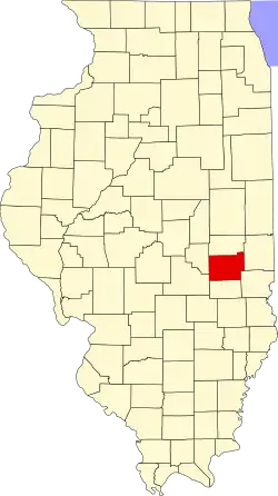 | |
| Villages | ||
| Townships | ||
| CDPs |
| |
| Unincorporated communities | ||
| Extinct community | ||
| Footnotes | ‡This populated place also has portions in an adjacent county or counties | |
Municipalities and communities of Cumberland County, Illinois, United States | ||
|---|---|---|
| Cities | 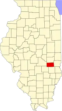 | |
| Villages | ||
| Townships | ||
| CDPs |
| |
| Unincorporated communities | ||
| Footnotes | ‡This populated place also has portions in an adjacent county or counties | |