Jamaica, Virginia
Jamaica, Virginia | |
|---|---|
 Jamaica, Virginia  Jamaica, Virginia | |
| Coordinates: 37°42′55″N 76°41′39″W / 37.71528°N 76.69417°W | |
| Country | United States |
| State | Virginia |
| County | Middlesex |
| Elevation | 105 ft (32 m) |
| Time zone | UTC-5 (Eastern (EST)) |
| • Summer (DST) | UTC-4 (EDT) |
| ZIP code | 23079[1] |
| Area code | 804 |
| GNIS feature ID | 1477442[2] |
Jamaica is an unincorporated community in Middlesex County, Virginia, United States. Jamaica is located on U.S. Route 17, 9.3 miles (15.0 km) northwest of Saluda. Jamaica had a post office, which closed on August 5, 2006.[1][3] Montague Island, which is on the Rappahannock River, is located in Jamaica.[4] The Virginia Motor Speedway is located in Jamaica.
References
- ^ a b United States Postal Service (2012). "USPS - Look Up a ZIP Code". Retrieved February 15, 2012.
- ^ "Jamaica". Geographic Names Information System. United States Geological Survey, United States Department of the Interior.
- ^ "Postmaster Finder - Post Offices by ZIP Code". United States Postal Service. Archived from the original on October 17, 2020. Retrieved August 20, 2012.
- ^ Reynolds Lux, Mary Jo (September 11, 2015). Three Hundred and Fifty-seven Years on Montague Island. pp. 14–15. ISBN 9780692521656.
Municipalities and communities of Middlesex County, Virginia, United States | ||
|---|---|---|
| Town | 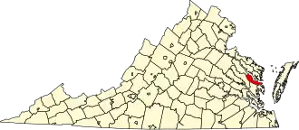 | |
| CDPs | ||
| Unincorporated communities | ||
| Footnotes | ‡This populated place also has portions in an adjacent county or counties | |