Jakubovice
Jakubovice | |
|---|---|
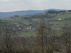 View from the east | |
 Flag .svg.png) Coat of arms | |
 Jakubovice Location in the Czech Republic | |
| Coordinates: 49°59′40″N 16°49′44″E / 49.99444°N 16.82889°E | |
| Country | |
| Region | Olomouc |
| District | Šumperk |
| First mentioned | 1351 |
| Area | |
• Total | 7.90 km2 (3.05 sq mi) |
| Elevation | 495 m (1,624 ft) |
| Population (2025-01-01)[1] | |
• Total | 210 |
| • Density | 27/km2 (69/sq mi) |
| Time zone | UTC+1 (CET) |
| • Summer (DST) | UTC+2 (CEST) |
| Postal codes | 789 91 |
| Website | www |
Jakubovice (German: Jokelsdorf) is a municipality and village in Šumperk District in the Olomouc Region of the Czech Republic. It has about 200 inhabitants. The village is well preserved and is protected as a village monument zone.
Jakubovice lies approximately 11 kilometres (7 mi) north-west of Šumperk, 55 km (34 mi) north-west of Olomouc, and 173 km (107 mi) east of Prague.
Demographics
| Year | Pop. | ±% |
|---|---|---|
| 1869 | 615 | — |
| 1880 | 582 | −5.4% |
| 1890 | 576 | −1.0% |
| 1900 | 628 | +9.0% |
| 1910 | 586 | −6.7% |
| 1921 | 547 | −6.7% |
| 1930 | 524 | −4.2% |
| 1950 | 290 | −44.7% |
| 1961 | 250 | −13.8% |
| 1970 | 231 | −7.6% |
| 1980 | 207 | −10.4% |
| 1991 | 174 | −15.9% |
| 2001 | 184 | +5.7% |
| 2011 | 203 | +10.3% |
| 2021 | 206 | +1.5% |
| Source: Censuses[2][3] | ||
References
- ^ "Population of Municipalities – 1 January 2025". Czech Statistical Office. 2025-05-16.
- ^ "Historický lexikon obcí České republiky 1869–2011" (in Czech). Czech Statistical Office. 2015-12-21.
- ^ "Population Census 2021: Population by sex". Public Database. Czech Statistical Office. 2021-03-27.
External links
Wikimedia Commons has media related to Jakubovice.