Hozelec
Hozelec | |
|---|---|
 Flag | |
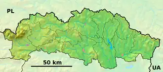 Hozelec Location of Hozelec in the Prešov Region  Hozelec Location of Hozelec in Slovakia | |
| Coordinates: 49°02′N 20°21′E / 49.03°N 20.35°E | |
| Country | |
| Region | |
| District | Poprad District |
| First mentioned | 1243 |
| Area | |
• Total | 4.00 km2 (1.54 sq mi) |
| Elevation | 683 m (2,241 ft) |
| Population (2021)[3] | |
• Total | 782 |
| Time zone | UTC+1 (CET) |
| • Summer (DST) | UTC+2 (CEST) |
| Postal code | 591 1[2] |
| Area code | +421 52[2] |
| Car plate | PP |
| Website | www |
Hozelec is a village and municipality in Poprad District in the Prešov Region of northern Slovakia.[4]
Geography
The municipality lies at an altitude of 695 metres and covers an area of 4.011 km2. It has a population of about 830 people.
History
In historical records the village was first mentioned in 1248.
Economy and infrastructure
Hozelec is a typical touristic village in High Tatras with good touristic infrastructure. In the village is Children amusement park FunVille.
See also
References
- ^ "Hustota obyvateľstva - obce [om7014rr_ukaz: Rozloha (Štvorcový meter)]". www.statistics.sk (in Slovak). Statistical Office of the Slovak Republic. 2022-03-31. Retrieved 2022-03-31.
- ^ a b c "Základná charakteristika". www.statistics.sk (in Slovak). Statistical Office of the Slovak Republic. 2015-04-17. Retrieved 2022-03-31.
- ^ "Počet obyvateľov podľa pohlavia - obce (ročne)". www.statistics.sk (in Slovak). Statistical Office of the Slovak Republic. 2022-03-31. Retrieved 2022-03-31.
- ^ "Statistical Office of the Slovak Republic" (PDF). Výsledky SODB 2011. Štatistický úrad SR. Archived from the original (PDF) on 2013-10-12. Retrieved 9 August 2012.
Genealogical resources
The records for genealogical research are available at the state archive "Statny Archiv in Levoca, Slovakia"
- Roman Catholic church records (births/marriages/deaths): 1731-1896 (parish B)
- Lutheran church records (births/marriages/deaths): 1710-1910 (parish B)
External links
Municipalities of Poprad District | ||
|---|---|---|