Hostovlice
Hostovlice | |
|---|---|
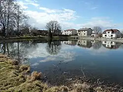 Houses around a pond | |
 Flag  Coat of arms | |
 Hostovlice Location in the Czech Republic | |
| Coordinates: 49°51′37″N 15°27′59″E / 49.86028°N 15.46639°E | |
| Country | |
| Region | Central Bohemian |
| District | Kutná Hora |
| First mentioned | 1244 |
| Area | |
• Total | 5.85 km2 (2.26 sq mi) |
| Elevation | 281 m (922 ft) |
| Population (2025-01-01)[1] | |
• Total | 247 |
| • Density | 42/km2 (110/sq mi) |
| Time zone | UTC+1 (CET) |
| • Summer (DST) | UTC+2 (CEST) |
| Postal code | 285 62 |
| Website | www |
Hostovlice is a municipality and village in Kutná Hora District in the Central Bohemian Region of the Czech Republic. It has about 200 inhabitants.
Demographics
| Year | Pop. | ±% |
|---|---|---|
| 1869 | 473 | — |
| 1880 | 584 | +23.5% |
| 1890 | 596 | +2.1% |
| 1900 | 562 | −5.7% |
| 1910 | 673 | +19.8% |
| 1921 | 708 | +5.2% |
| 1930 | 583 | −17.7% |
| 1950 | 403 | −30.9% |
| 1961 | 353 | −12.4% |
| 1970 | 351 | −0.6% |
| 1980 | 299 | −14.8% |
| 1991 | 279 | −6.7% |
| 2001 | 246 | −11.8% |
| 2011 | 253 | +2.8% |
| 2021 | 245 | −3.2% |
| Source: Censuses[2][3] | ||
References
- ^ "Population of Municipalities – 1 January 2025". Czech Statistical Office. 2025-05-16.
- ^ "Historický lexikon obcí České republiky 1869–2011" (in Czech). Czech Statistical Office. 2015-12-21.
- ^ "Population Census 2021: Population by sex". Public Database. Czech Statistical Office. 2021-03-27.
External links
Wikimedia Commons has media related to Hostovlice.