Horní Němčí
Horní Němčí | |
|---|---|
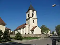 Church of Saints Peter and Paul | |
 Flag  Coat of arms | |
 Horní Němčí Location in the Czech Republic | |
| Coordinates: 48°55′59″N 17°37′27″E / 48.93306°N 17.62417°E | |
| Country | |
| Region | Zlín |
| District | Uherské Hradiště |
| First mentioned | 1261 |
| Area | |
• Total | 17.93 km2 (6.92 sq mi) |
| Elevation | 334 m (1,096 ft) |
| Population (2025-01-01)[1] | |
• Total | 809 |
| • Density | 45/km2 (120/sq mi) |
| Time zone | UTC+1 (CET) |
| • Summer (DST) | UTC+2 (CEST) |
| Postal code | 687 64 |
| Website | www |
Horní Němčí is a municipality and village in Uherské Hradiště District in the Zlín Region of the Czech Republic. It has about 800 inhabitants.
Horní Němčí lies approximately 20 kilometres (12 mi) south-east of Uherské Hradiště, 41 km (25 mi) south of Zlín, and 297 km (185 mi) south-east of Prague.
Demographics
| Year | Pop. | ±% |
|---|---|---|
| 1869 | 920 | — |
| 1880 | 919 | −0.1% |
| 1890 | 1,067 | +16.1% |
| 1900 | 1,168 | +9.5% |
| 1910 | 1,310 | +12.2% |
| 1921 | 1,344 | +2.6% |
| 1930 | 1,369 | +1.9% |
| 1950 | 1,082 | −21.0% |
| 1961 | 1,172 | +8.3% |
| 1970 | 1,082 | −7.7% |
| 1980 | 947 | −12.5% |
| 1991 | 866 | −8.6% |
| 2001 | 829 | −4.3% |
| 2011 | 829 | +0.0% |
| 2021 | 784 | −5.4% |
| Source: Censuses[2][3] | ||
References
- ^ "Population of Municipalities – 1 January 2025". Czech Statistical Office. 2025-05-16.
- ^ "Historický lexikon obcí České republiky 1869–2011" (in Czech). Czech Statistical Office. 2015-12-21.
- ^ "Population Census 2021: Population by sex". Public Database. Czech Statistical Office. 2021-03-27.
External links
Wikimedia Commons has media related to Horní Němčí.