Holdman, Oregon
Holdman | |
|---|---|
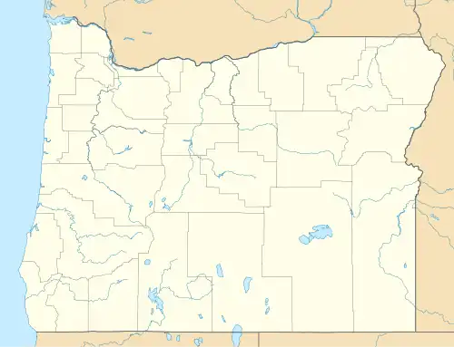 Holdman Location within the state of Oregon  Holdman Holdman (the United States) | |
| Coordinates: 45°52′19″N 118°55′57″W / 45.87194°N 118.93250°W[1] | |
| Country | United States |
| State | Oregon |
| County | Umatilla |
| Elevation | 1,007 ft (307 m) |
| Time zone | UTC-8 (Pacific (PST)) |
| • Summer (DST) | UTC-7 (PDT) |
| ZIP code | 97835 |
| Area codes | 458 and 541 |
| GNIS feature ID | 1121899[1] |
Holdman is an unincorporated community in Umatilla County, Oregon, United States. It is about 17.5 miles (28.2 km) north-northwest of Pendleton and approximately 12.5 miles (20.1 km) east of Hermiston, at the intersection of County Road 800 and the Pendleton-Cold Springs Highway. The town was named for the Holdman brothers, early settlers of the area.[2] Holdman post office was established in 1900.[2]
In 1915, Holdman was described as having a population of 25, with a United Brethren church and a schoolhouse.[3] The schoolhouse is still standing as of 2024.
Holdman is part of the Pendleton–Hermiston Micropolitan Statistical Area.
References
- ^ a b c U.S. Geological Survey Geographic Names Information System: Holdman, Oregon
- ^ a b The Hartle Family of Holdman by Tom Kasinger from gesswhoto.com
- ^ Burke, Thomas C. (1915). The State of Oregon: Its Resources and Opportunities. Portland, OR: State Immigration Commission. p. 258.
Municipalities and communities of Umatilla County, Oregon, United States | ||
|---|---|---|
| Cities | 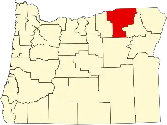 | |
| CDPs | ||
| Other communities | ||
| Indian reservation | ||
| Ghost towns | ||
| Footnotes | ‡This populated place also has portions in an adjacent county or counties | |