Hohnstein
Hohnstein | |
|---|---|
.jpg) General view of the town | |
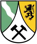
 Coat of arms | |
Location of Hohnstein within Sächsische Schweiz-Osterzgebirge district 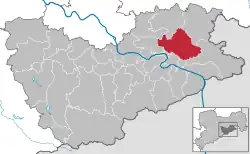 | |
 Hohnstein  Hohnstein | |
| Coordinates: 50°59′N 14°07′E / 50.983°N 14.117°E | |
| Country | Germany |
| State | Saxony |
| District | Sächsische Schweiz-Osterzgebirge |
| Government | |
| • Mayor (2022–29) | Daniel Brade[1] |
| Area | |
• Total | 64.64 km2 (24.96 sq mi) |
| Elevation | 330 m (1,080 ft) |
| Population (2023-12-31)[2] | |
• Total | 3,170 |
| • Density | 49/km2 (130/sq mi) |
| Time zone | UTC+01:00 (CET) |
| • Summer (DST) | UTC+02:00 (CEST) |
| Postal codes | 01848 |
| Dialling codes | 035975 |
| Vehicle registration | PIR |
| Website | www.hohnstein.de |
Hohnstein (German pronunciation: [ˈhoːnˌʃtaɪn] ⓘ) is a town located in the Sächsische Schweiz-Osterzgebirge district of Saxony, in eastern Germany. As of 2020, its population numbered a total of 3,262.
Geography
It is situated in Saxon Switzerland, 12 km east of Pirna, and 28 km southeast of Dresden (centre). It is dominated by its castle, standing on a sandstone rock.
The municipal territory includes the villages (Ortsteile) of Cunnersdorf, Ehrenberg, Goßdorf, Lohsdorf, Rathewalde, Ulbersdorf and Waitzdorf.
History
In 1900, the town had a population of 1,321.[3]
During the German invasion of Poland at the start of World War II, in September 1939, the Oflag IV-A prisoner-of-war camp for Polish officers was established at the local castle, and from 1940 it also held French and Belgian officers and orderlies.[4] In 1941, the Oflag IV-A was dissolved, and the Stalag IV-A POW camp was relocated to Hohnstein from Elsterhorst.[4] It held Polish, French, British, Belgian, Serbian, Dutch, Soviet, Italian, American, Slovak, Czech and Bulgarian POWs, and was liberated by the Soviets in April 1945.[4]
Gallery
-
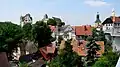 View of the town and the castle.
 -
 Town's church
 -
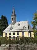 Church in Rathewalde
 -
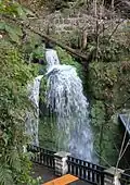 The Amsel Falls near Rathewalde
 -
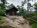 Shelter on the Hockstein in the Saxon Switzerland National Park
See also
- Hohnstein Castle (Saxon Switzerland)
- Schwarzbach Railway
- Goßdorf-Kohlmühle railway station
- Ulbersdorf railway station
References
- ^ Gewählte Bürgermeisterinnen und Bürgermeister im Freistaat Sachsen, Stand: 17. Juli 2022, Statistisches Landesamt des Freistaates Sachsen.
- ^ "Bevölkerung der Gemeinden Sachsens am 31. Dezember 2023 - Fortschreibung des Bevölkerungsstandes auf Basis des Zensus vom 15. Mai 2022 (Gebietsstand 01.01.2023)" (in German). Statistisches Landesamt des Freistaates Sachsen.
- ^ Meyers Großes Konversations-Lexikon. Vol. 9. Leipzig und Wien. 1906. p. 467.
{{cite book}}: CS1 maint: location missing publisher (link) - ^ a b c Megargee, Geoffrey P.; Overmans, Rüdiger; Vogt, Wolfgang (2022). The United States Holocaust Memorial Museum Encyclopedia of Camps and Ghettos 1933–1945. Volume IV. Indiana University Press, United States Holocaust Memorial Museum. pp. 236, 413. ISBN 978-0-253-06089-1.
External links
![]() Media related to Hohnstein at Wikimedia Commons
Media related to Hohnstein at Wikimedia Commons
- Newsreel WK2 from a private archive: http://www.archiv-akh.de/filme#1549 (Material Nr 1966, Time 10:17:28)