Hoštice (Kroměříž District)
Hoštice | |
|---|---|
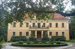 Hoštice Castle | |
_flag.png) Flag _CoA_CZ.jpg) Coat of arms | |
 Hoštice Location in the Czech Republic | |
| Coordinates: 49°12′31″N 17°14′2″E / 49.20861°N 17.23389°E | |
| Country | |
| Region | Zlín |
| District | Kroměříž |
| First mentioned | 1141 |
| Area | |
• Total | 7.57 km2 (2.92 sq mi) |
| Elevation | 306 m (1,004 ft) |
| Population (2025-01-01)[1] | |
• Total | 157 |
| • Density | 21/km2 (54/sq mi) |
| Time zone | UTC+1 (CET) |
| • Summer (DST) | UTC+2 (CEST) |
| Postal code | 768 13 |
| Website | obechostice |
Hoštice is a municipality and village in Kroměříž District in the Zlín Region of the Czech Republic. It has about 200 inhabitants.
Hoštice lies approximately 16 kilometres (10 mi) south-west of Kroměříž, 32 km (20 mi) west of Zlín, and 225 km (140 mi) south-east of Prague.
Demographics
| Year | Pop. | ±% |
|---|---|---|
| 1869 | 560 | — |
| 1880 | 548 | −2.1% |
| 1890 | 554 | +1.1% |
| 1900 | 562 | +1.4% |
| 1910 | 546 | −2.8% |
| 1921 | 539 | −1.3% |
| 1930 | 510 | −5.4% |
| 1950 | 414 | −18.8% |
| 1961 | 417 | +0.7% |
| 1970 | 367 | −12.0% |
| 1980 | 235 | −36.0% |
| 1991 | 214 | −8.9% |
| 2001 | 173 | −19.2% |
| 2011 | 166 | −4.0% |
| 2021 | 157 | −5.4% |
| Source: Censuses[2][3] | ||
References
- ^ "Population of Municipalities – 1 January 2025". Czech Statistical Office. 2025-05-16.
- ^ "Historický lexikon obcí České republiky 1869–2011" (in Czech). Czech Statistical Office. 2015-12-21.
- ^ "Population Census 2021: Population by sex". Public Database. Czech Statistical Office. 2021-03-27.
External links
Wikimedia Commons has media related to Hoštice (Kroměříž District).