Hitiaʻa O Te Ra
Hitiaʻa O Te Ra | |
|---|---|
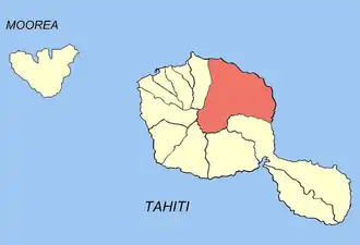 Location of the commune (in red) within the Windward Islands | |
Location of Hitiaʻa O Te Ra | |
| Coordinates: 17°37′S 149°19′W / 17.61°S 149.31°W | |
| Country | France |
| Overseas collectivity | French Polynesia |
| Subdivision | Windward Islands |
| Government | |
| • Mayor (2020–2026) | Henri Flohr[1] |
Area 1 | 218.2 km2 (84.2 sq mi) |
| Population (2022)[2] | 10,196 |
| • Density | 47/km2 (120/sq mi) |
| Time zone | UTC−10:00 |
| INSEE/Postal code | 98722 /98705 |
| Elevation | 0–2,241 m (0–7,352 ft) |
| 1 French Land Register data, which excludes lakes, ponds, glaciers > 1 km2 (0.386 sq mi or 247 acres) and river estuaries. | |
Hitiaʻa O Te Ra is a commune of French Polynesia, an overseas territory of France in the Pacific Ocean. The commune of Hitiaʻa O Te Ra is located on the island of Tahiti, in the administrative subdivision of the Windward Islands,[3] themselves part of the Society Islands. At the 2022 census it had a population of 10,196.[2]
Hitiaʻa O Te Ra consists of the following associated communes:[4]
The administrative center of the commune is the settlement of Tiarei.[4]
References
- ^ "Répertoire national des élus: les maires" (in French). data.gouv.fr, Plateforme ouverte des données publiques françaises. 13 September 2022.
- ^ a b "Les résultats du recensement de la population 2022 de Polynésie française" [Results of the 2022 population census of French Polynesia] (PDF) (in French). Institut de la statistique de la Polynésie française. January 2023.
- ^ Décret n° 2005-1611 du 20 décembre 2005 pris pour l'application du statut d'autonomie de la Polynésie française, Légifrance
- ^ a b Décret n°72-407 du 17 mai 1972 portant création de communes dans le territoire de la Polynésie française, Légifrance
Wikimedia Commons has media related to Hitiaa O Te Ra.