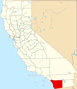
Harmony Grove, California
Harmony Grove, California | |
|---|---|
 Harmony Grove | |
| Coordinates: 33°6′2.58″N 117°8′16.77″W / 33.1007167°N 117.1379917°W | |
| Country | |
| State | |
| County | |
| Area | |
• Total | 7.98 km2 (3.081 sq mi) |
| • Land | 7.98 km2 (3.081 sq mi) |
| • Water | 0 km2 (0 sq mi) |
| Elevation | 219 m (719 ft) |
| Population (2020) | |
• Total | 2,079 |
| • Density | 260/km2 (670/sq mi) |
| Time zone | UTC-8 (PST) |
| • Summer (DST) | UTC-7 (PDT) |
| GNIS feature ID | 2813413[1] |
Harmony Grove is an unincorporated community and census-designated place (CDP) in San Diego County, California, United States. Per the 2020 census, the population was 2,079.[2]
Demographics
| Census | Pop. | Note | %± |
|---|---|---|---|
| 2020 | 2,079 | — | |
| U.S. Decennial Census[3] 2020[4] | |||
Harmony Grove first appeared as a CDP in the 2020 census.[5][4]
2020 Census
| Race / Ethnicity (NH = Non-Hispanic) | Pop 2020[4] | % 2020 |
|---|---|---|
| White alone (NH) | 1,087 | 52.28% |
| Black or African American alone (NH) | 58 | 2.79% |
| Native American or Alaska Native alone (NH) | 4 | 0.19% |
| Asian alone (NH) | 427 | 20.54% |
| Native Hawaiian or Pacific Islander alone (NH) | 2 | 0.10% |
| Other race alone (NH) | 18 | 0.87% |
| Mixed race or Multiracial (NH) | 155 | 7.46% |
| Hispanic or Latino (any race) | 328 | 15.78% |
| Total | 2,079 | 100.00% |
Education
The CDP is in Escondido Union Elementary School District and Escondido Union High School District.[6]
References
- ^ a b "Harmony Grove Census Designated Place". Geographic Names Information System. United States Geological Survey, United States Department of the Interior.
- ^ "Harmony Grove CDP, Georgia". United States Census Bureau. Retrieved January 15, 2024.
- ^ "Decennial Census of Population and Housing by Decades". US Census Bureau.
- ^ a b c "P2: Hispanic or Latino, and Not Hispanic or Latino by Race – 2020: DEC Redistricting Data (PL 94-171) – Harmony Grove CDP, California". United States Census Bureau. Retrieved January 26, 2024.
- ^ "2020 Geography Changes". United States Census Bureau.
- ^ "2020 census - school district reference map: San Diego County, CA" (PDF). U.S. Census Bureau. p. 2 (PDF p. 3/7). Retrieved December 21, 2024. - Text list