Hantet
Hantet | |
|---|---|
 Hantet Location in Burma | |
| Coordinates: 24°5′N 97°13′E / 24.083°N 97.217°E | |
| Country | |
| State | Kachin State |
| District | Bhamo District |
| Township | Bhamo Township |
| Population (2005) | |
| • Religions | Buddhism |
| Time zone | UTC+6.30 (UTC + 6:30) |
Hantet is a village in Bhamo Township in Bhamo District in the Kachin State of north-eastern Burma.[1]
References
- ^ Maplandia world gazetteer
External links
Capital: Myitkyina | ||
| Bhamo District |  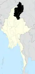 | |
| Mohnyin District | ||
| Myitkyina District | ||
| Chipwi District | ||
| Putao District | ||
| Tanai District | ||
| Main cities and towns | ||