Golden View Colony, South Dakota
Golden View Colony, South Dakota | |
|---|---|
 Golden View Colony  Golden View Colony | |
| Coordinates: 43°41′44″N 97°26′55″W / 43.69556°N 97.44861°W | |
| Country | United States |
| State | South Dakota |
| County | McCook |
| Area | |
• Total | 1.00 sq mi (2.58 km2) |
| • Land | 0.96 sq mi (2.50 km2) |
| • Water | 0.03 sq mi (0.08 km2) |
| Elevation | 1,499 ft (457 m) |
| Population | |
• Total | 95 |
| • Density | 98.55/sq mi (38.06/km2) |
| Time zone | UTC-6 (Central (CST)) |
| • Summer (DST) | UTC-5 (CDT) |
| ZIP Code | 57058 (Salem) |
| Area code | 605 |
| FIPS code | 46-24760 |
| GNIS feature ID | 2813045[2] |
Golden View Colony is a census-designated place (CDP) corresponding to the Goldenview Hutterite colony[4] in McCook County, South Dakota, United States. The population was 95 at the 2020 census.[5] It was first listed as a CDP prior to the 2020 census.[2]
It is in the west-central part of the county, 5 miles (8 km) by road southwest of Salem, the county seat.
Demographics
| Census | Pop. | Note | %± |
|---|---|---|---|
| 2020 | 95 | — | |
| U.S. Decennial Census[6] | |||
References
- ^ "ArcGIS REST Services Directory". United States Census Bureau. Retrieved October 15, 2022.
- ^ a b c U.S. Geological Survey Geographic Names Information System: Golden View Colony, South Dakota
- ^ "Census Population API". United States Census Bureau. Retrieved October 15, 2022.
- ^ Friesen, Bert (May 2021). "Goldenview Hutterite Colony (Salem, South Dakota, USA)". Global Anabaptist Mennonite Encyclopedia Online. Retrieved September 16, 2021.
- ^ "U.S. Census Bureau: Golden View Colony CDP, South Dakota". www.census.gov. United States Census Bureau. Retrieved March 19, 2022.
- ^ "Census of Population and Housing". Census.gov. Retrieved June 4, 2016.
Municipalities and communities of McCook County, South Dakota, United States | ||
|---|---|---|
| Cities | 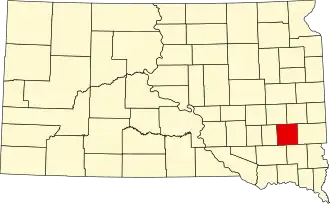 | |
| CDPs | ||
| Unincorporated community | ||