Gill Township, Clay County, Kansas
Gill Township | |
|---|---|
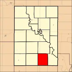 Location within Clay County | |
| Coordinates: 39°10′30″N 097°06′31″W / 39.17500°N 97.10861°W[1] | |
| Country | United States |
| State | Kansas |
| County | Clay |
| Area | |
• Total | 30.09 sq mi (77.93 km2) |
| • Land | 30.07 sq mi (77.89 km2) |
| • Water | 0.01 sq mi (0.03 km2) 0.04% |
| Elevation | 1,335 ft (407 m) |
| Population (2020) | |
• Total | 146 |
| • Density | 4.9/sq mi (1.9/km2) |
| Time zone | UTC-6 (CST) |
| • Summer (DST) | UTC-5 (CDT) |
| FIPS code | 20-26250 [1] |
| GNIS ID | 476318 [1] |
Gill Township is a township in Clay County, Kansas, United States.[1] As of the 2020 census, its population was 146.[2]
Geography
Gill Township covers an area of 30.09 square miles (77.9 km2) and contains no incorporated settlements.
According to the USGS, it contains one cemetery, Saint Johns.
References
Further reading
Municipalities and communities of Clay County, Kansas, United States | ||
|---|---|---|
| Cities | 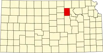 | |
| CDP | ||
| Unincorporated communities | ||
| Ghost towns | ||
| Townships | ||
| Footnotes | ‡This community also has portions in an adjacent county or counties. | |