Garfield, Portage County, Wisconsin
Garfield, Wisconsin | |
|---|---|
 Garfield, Wisconsin  Garfield, Wisconsin | |
| Coordinates: 44°33′43.4″N 89°17′38.1″W / 44.562056°N 89.293917°W | |
| Country | |
| State | |
| County | Portage |
| Elevation | 349 m (1,145 ft) |
| Time zone | UTC-6 (Central (CST)) |
| • Summer (DST) | UTC-5 (CDT) |
| Area codes | 715 and 534 |
| GNIS feature ID | 1577608[1] |
Garfield is an unincorporated community in Portage County, Wisconsin, United States.[1][2]
Geography
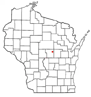
Garfield is located in central Wisconsin approximately halfway between Rosholt and Nelsonville on Portage County Road A, about 2+1⁄2 miles (4.0 km) west of Peru. It rests on the present-day location in the Town of New Hope on the intersection of Portage County Roads A south and Z to the east.
Poncho Creek and the Tomorrow River southwest of Garfield are becoming a part of the Richard A. Hemp Fishery Area.[3]
References
External links
- here Archived 2012-05-12 at the Wayback Machine to visit the Portage County Historical Society.
Municipalities and communities of Portage County, Wisconsin, United States | ||
|---|---|---|
| City |  | |
| Villages | ||
| Towns | ||
| CDPs | ||
| Other communities | ||
| Former community | ||
| Footnotes | ‡This populated place also has portions in an adjacent county or counties | |