Fray Marcos
Fray Marcos | |
|---|---|
Town | |
 Fray Marcos Location in Uruguay | |
| Coordinates: 34°11′0″S 55°44′0″W / 34.18333°S 55.73333°W | |
| Country | |
| Department | Florida Department |
| Founded | 1888 |
| Population (2011) | |
• Total | 2,398 |
| Time zone | UTC −3 |
| Postal code | 90601 |
| Dial plan | +598 4311 (+4 digits) |
Fray Marcos is a town in the Florida Department of southern-central Uruguay.
Geography
It is located 2 kilometres (1.2 mi) north of the Santa Lucía River (the border with Canelones Department) and on the junction of Route 7 with Route 94. It is 96 kilometres (60 mi) north of Montevideo and on kilometre 107 of the railroad track Montevideo – Nico Pérez.
History
It was founded in December 1888, and on 23 May 1919, it was declared a "Pueblo" (village) by the Act of Ley Nº 6.906.[1] Its status was elevated to "Villa" (town) on 5 July 1956 by the Act of Ley Nº 12.297.[2]
Population
In 2011 Fray Marcos had a population of 2,398.[3]
| Year | Population |
|---|---|
| 1963 | 1,403 |
| 1975 | 1,568 |
| 1985 | 1,676 |
| 1996 | 2,053 |
| 2004 | 2,509 |
| 2011 | 2,398 |
Source: Instituto Nacional de Estadística de Uruguay[1]
Places of worship
- Most Pure Heart of Mary Parish Church (Roman Catholic)
References
- ^ a b "Statistics of urban localities (1963–2004)" (PDF). INE. 2012. Archived from the original (PDF) on 13 November 2009. Retrieved 4 September 2012.
- ^ "LEY N° 12.297". República Oriental del Uruguay, Poder Legislativo. 1956. Archived from the original on 4 March 2016. Retrieved 29 June 2011.
- ^ "Censos 2011 Cuadros Florida". INE. 2012. Archived from the original on 10 October 2012. Retrieved 25 August 2012.
External links
Wikivoyage has a travel guide for Fray Marcos.
Capital: Florida | ||
| Towns and villages | 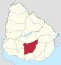 | |
| Sights | ||