Florence, El Dorado, and Walnut Valley Railroad
The Florence, El Dorado, and Walnut Valley Railroad was a short-line railroad in central Kansas.
History
In 1877, the Florence, El Dorado, and Walnut Valley Railroad Company built a branch line from Florence to El Dorado. In 1881, it was extended to Douglass, and later to Arkansas City.[1] In 1901, the line was leased and operated by the Atchison, Topeka and Santa Fe Railway, which used the name "Florence & Arkansas City Division" for it.[2]
The line from Florence to El Dorado was abandoned in 1942[3][4] to reclaim the metal rails for the war effort during World War II because of a shortage of materials during those years.
Currently, the remaining part of the former Florence, El Dorado, and Walnut Valley Railroad that still exists is:[5]
- El Dorado to Arkansas City.
Stations
At a high-level, the railroad connected the primary cities of Florence (north end), El Dorado, Augusta, Winfield, Arkansas City (south end).
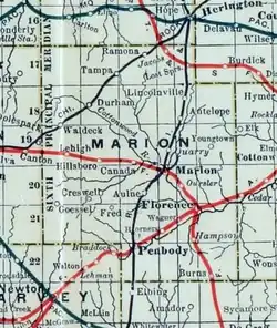
- Marion County
- Butler County
- Cowley County
- Rock
- Akron, station [7]
- Winfield
- Arkansas City (south end)
See also
- Marion and McPherson Railroad, a defunct railroad that started in Florence.
- Southern Transcon, currently uses tracks from El Dorado to Augusta.
- List of Kansas railroads
References
- ^ Marion County Kansas : Past and Present; Sondra Van Meter; MB Publishing House; LCCN 72-92041; 344 pages; 1972.
- ^ Florence & Arkansas City Division in Kansas: A Cyclopedia of State History; Standard Publishing Co; 805 pages; 1912.
- ^ Railway Abandonment 1942
- ^ "Burns Suffers From Stopped Rail Service, page 7; Peabody Gazette-Bulletin; 8 pages; October 8, 1942". Archived from the original on 2014-05-21. Retrieved 2014-05-21.
- ^ Kansas Railroad Map; KDOT.
- ^ Hampson in Kansas: A Cyclopedia of State History; Standard Publishing Co; 805 pages; 1912.
- ^ Akron in Kansas: A Cyclopedia of State History; Standard Publishing Co; 805 pages; 1912.
Further reading
- Stouffer's Railroad Map of Kansas; J.W. Stouffer; 1 page; 1915–1918.
- Standard Atlas of Marion County, Kansas; Geo. A. Ogle & Co; 103 pages; 1902.
- Standard Atlas of Butler County, Kansas; Geo. A. Ogle & Co; 69 pages; 1905.
- Standard Atlas of Cowley County, Kansas; Geo. A. Ogle & Co; 54 pages; 1905.