Elmrock, Kentucky
Elmrock, Kentucky | |
|---|---|
 Elmrock  Elmrock | |
| Coordinates: 37°27′08″N 83°01′33″W / 37.45222°N 83.02583°W | |
| Country | United States |
| State | Kentucky |
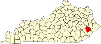
| County | Knott |
| Elevation | 1,014 ft (309 m) |
| Time zone | UTC-5 (Eastern (EST)) |
| • Summer (DST) | UTC-4 (EDT) |
| Area code | 606 |
| GNIS feature ID | 507932[1] |
Elmrock is an unincorporated community in Knott County, Kentucky, United States. Elmrock is located on Kentucky Route 1098 8.4 miles (13.5 km) north-northwest of Hindman.[2] Elmrock had a post office from August 9, 1911, to September 2, 1989.[3] The community was named for a large elm tree and large rock in the town.[4]
References
- ^ "Elmrock". Geographic Names Information System. United States Geological Survey, United States Department of the Interior.
- ^ State Primary Road System: Knott County (PDF) (Map). Kentucky Transportation Cabinet. 2010. Retrieved February 23, 2013.
- ^ "Postmaster Finder - Post Offices by ZIP Code". United States Postal Service. Archived from the original on October 17, 2020. Retrieved February 23, 2013.
- ^ Rennick, Robert M. (1987). Kentucky Place Names. University Press of Kentucky. p. 375. ISBN 9780813126319.
Municipalities and communities of Knott County, Kentucky, United States | ||
|---|---|---|
| Cities |
|  |
| Unincorporated communities | ||
| post offices (and the creeks they are on) |
| |
| Footnotes | ‡This populated place also has portions in an adjacent county or counties. | |