Dale Township, Kingman County, Kansas
Dale Township | |
|---|---|
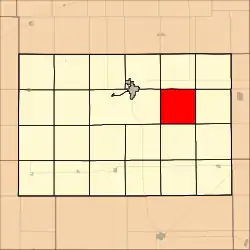 Location in Kingman County | |
| Coordinates: 37°36′15″N 97°58′21″W / 37.60417°N 97.97250°W | |
| Country | United States |
| State | Kansas |
| County | Kingman |
| Area | |
• Total | 35.37 sq mi (91.6 km2) |
| • Land | 35.07 sq mi (90.83 km2) |
| • Water | 0.3 sq mi (0.77 km2) 0.84% |
| Elevation | 1,440 ft (439 m) |
| Population (2000) | |
• Total | 203 |
| • Density | 5.8/sq mi (2.2/km2) |
| GNIS feature ID | 0485464 |
Dale Township is a township in Kingman County, Kansas, United States. As of the 2000 census, its population was 203.[1]
Geography
Dale Township covers an area of 35.37 square miles (91.6 square kilometers); of this, 0.3 square miles (0.77 square kilometers) or 0.84 percent is water. The stream of Sand Creek runs through this township.
Communities
- Georgia
- Murdock
(This list is based on USGS data and may include former settlements.)
Adjacent townships
- Galesburg Township (north)
- Evan Township (northeast)
- Vinita Township (east)
- Allen Township (southeast)
- Eagle Township (south)
- Richland Township (southwest)
- Ninnescah Township (west)
- White Township (northwest)
Cemeteries
The township contains two cemeteries: Bethany and Murdock.
References
- ^ "U.S. Census website". Retrieved June 24, 2008.
External links
Municipalities and communities of Kingman County, Kansas, United States | ||
|---|---|---|
| Cities | 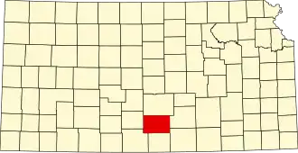 | |
| CDPs | ||
| Unincorporated communities |
| |
| Townships | ||