Cotaruse District
Cotaruse | |
|---|---|
| Country | |
| Region | Apurímac |
| Province | Aymaraes |
| Founded | June 1, 1914 |
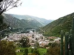
| Capital | Cotaruse |
| Government | |
| • Mayor | Alejandro Rojas Llacsa |
| Area | |
• Total | 1,749.83 km2 (675.61 sq mi) |
| Elevation | 3,248 m (10,656 ft) |
| Population | |
• Total | 3,576 |
| • Density | 2.0/km2 (5.3/sq mi) |
| Time zone | UTC-5 (PET) |
| UBIGEO | 030406 |
Cotaruse District is one of the seventeen districts of the Aymaraes Province in Peru.[1]
Geography
One of the highest peaks of the district is Pumanuta at approximately 4,800 m (15,700 ft). Other mountains are listed below:[2]
- Altarniyuq
- Aqu Q'asa
- Aycha Qullqa
- Chachakuma
- Chawpi Urqu
- Ichhu Marka
- Ichhu Sirk'a
- Inka Pirqa
- Kampanayuq
- Kuntur Marka
- Llamuqa
- Ñawin Urqu
- Pampa Quriwiri
- Parqa Saywa
- Puka Kunka
- Puka Pata
- Pukar
- Puma Allqa
- Phiruru
- Qaqa Wasi
- Qullqa Pampa
- Q'illa Wachu
- Q'illu
- Q'illu Q'illu
- Runtu Marka
- Sallikani
- Sillu Sillu
- Sura Pata
- Tintaya
- Uma Q'asa
- Wachu Willka
- Wamanripa
- Wamanripayuq
- Wararani
- Waylla Kunka
- Yana Mach'ay
- Yana Pata
- Yana Saya
- Yanama
- Yunka Wasi
Ethnic groups
The people in the district are mainly indigenous citizens of Quechua descent. Quechua is the language which the majority of the population (61.13%) learned to speak in childhood, while a minority (38.45%) of the residents learned to speak using the Spanish language (2007 Peru Census).[3]
References
- ^ (in Spanish) Instituto Nacional de Estadística e Informática. Banco de Información Digital Archived April 23, 2008, at the Wayback Machine. Retrieved April 7, 2008.
- ^ escale.minedu.gob.pe/ UGEL map Aymaraes Province (Apurímac Region)
- ^ inei.gob.pe Archived January 27, 2013, at the Wayback Machine INEI, Peru, Censos Nacionales 2007, Frequencias: Preguntas de Población: Idioma o lengua con el que aprendió hablar (in Spanish)
14°24′58″S 73°12′29″W / 14.41611°S 73.20806°W