Compass, Pennsylvania
Compass, Pennsylvania | |
|---|---|
Unincorporated community | |
_just_northwest_of_Octorara_Trail_in_West_Caln_Township%252C_Chester_County%252C_Pennsylvania.jpg) | |
 Compass  Compass | |
| Coordinates: 40°1′21″N 75°56′33″W / 40.02250°N 75.94250°W | |
| Country | United States |
| State | Pennsylvania |
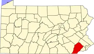
| County | Chester |
| Township | West Caln |
| Elevation | 518 ft (158 m) |
| Time zone | UTC-5 (Eastern (EST)) |
| • Summer (DST) | UTC-4 (EDT) |
| Area codes | 484, 610, 717 |
| GNIS feature ID | 1172273[1] |
Compass is an unincorporated community in West Caln Township in Chester County, Pennsylvania, United States. Compass is located at the intersection of state routes 10 and 340.[2]
The community was named after the image of a compass on the sign of a tavern.[3]
References
- ^ "Compass". Geographic Names Information System. United States Geological Survey, United States Department of the Interior.
- ^ "Chester County, Pennsylvania Highway Map" (PDF). PennDOT (FTP). 2012. Retrieved August 22, 2013. (To view documents see Help:FTP)
- ^ Moyer, Armond; Moyer, Winifred (1958). The origins of unusual place-names. Keystone Pub. Associates. p. 26.
Wikimedia Commons has media related to Compass, Pennsylvania.