Communauté d'agglomération de l'Auxerrois
Auxerrois | |
|---|---|
| Coordinates: 47°47′N 03°35′E / 47.783°N 3.583°E | |
| Country | France |
| Region | Bourgogne-Franche-Comté |
| Department | Yonne |
| No. of communes | 29 |
| Established | 2017 |
| Seat | Auxerre |
Area | 434.0 km2 (167.6 sq mi) |
| Population (2019) | 67,651 |
| • Density | 156/km2 (400/sq mi) |
| Website | www |
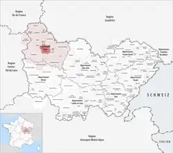
Communauté d'agglomération de l'Auxerrois is the communauté d'agglomération, an intercommunal structure, centred on the town of Auxerre. It is located in the Yonne department, in the Bourgogne-Franche-Comté region, central France. Created in 2017, its seat is in Auxerre.[1] Its area is 434.0 km2. Its population was 67,651 in 2019, of which 34,451 in Auxerre proper.[2]
Composition
The communauté d'agglomération consists of the following 29 communes:[1][3]
- Appoigny
- Augy
- Auxerre
- Bleigny-le-Carreau
- Branches
- Champs-sur-Yonne
- Charbuy
- Chevannes
- Chitry
- Coulanges-la-Vineuse
- Escamps
- Escolives-Sainte-Camille
- Gurgy
- Gy-l'Évêque
- Irancy
- Jussy
- Lindry
- Monéteau
- Montigny-la-Resle
- Perrigny
- Quenne
- Saint-Bris-le-Vineux
- Saint-Georges-sur-Baulche
- Vallan
- Venoy
- Villefargeau
- Villeneuve-Saint-Salves
- Vincelles
- Vincelottes
References
- ^ a b CA de l'Auxerrois (N° SIREN : 200067114), BANATIC. Retrieved 11 November 2024.
- ^ Comparateur de territoire, INSEE. Retrieved 21 November 2022.
- ^ "Intercommunalité : Communauté d'agglomération de L'Auxerrois". INSEE. Retrieved 11 November 2024.