Colburn, Indiana
Colburn, Indiana | |
|---|---|
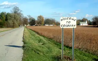 Looking east toward Colburn along County Road 700 North. Welcome sign made by Bill Fitzmaurice, a resident of Colburn for 25 years. | |
 Location of Colburn in Tippecanoe County, Indiana. | |
| Coordinates: 40°31′08″N 86°42′44″W / 40.51889°N 86.71222°W | |
| Country | United States |
| State | Indiana |
| County | Tippecanoe |
| Township | Washington |
| Founded | 1858 |
| Founder | Jacob H. Chapman |
| Area | |
• Total | 0.10 sq mi (0.26 km2) |
| • Land | 0.10 sq mi (0.26 km2) |
| • Water | 0.00 sq mi (0.00 km2) |
| Elevation | 663 ft (202 m) |
| Population (2020) | |
• Total | 164 |
| • Density | 1,640.00/sq mi (632.23/km2) |
| Time zone | UTC-5 (Eastern (EST)) |
| • Summer (DST) | UTC-4 (EDT) |
| Zip Code | 47905 |
| Area code | 765 |
| GNIS feature ID | 2583448[2] |
Colburn is a small unincorporated census-designated place in northeastern Washington Township, Tippecanoe County, in the U.S. state of Indiana.[2]
It is part of the Lafayette, Indiana Metropolitan Statistical Area.
History
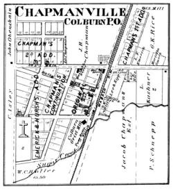
Colburn was originally called Chapmanville.[3]
A post office was established at Colburn in 1860, and remained in operation until it was discontinued in 1988.[4]
Geography
Colburn is located in Washington Township. Nearby communities include Lafayette (12 miles southwest), Delphi (6 miles north), Buck Creek (4 miles south) and Americus (3.5 miles west).
Demographics
| Census | Pop. | Note | %± |
|---|---|---|---|
| 2020 | 164 | — | |
| U.S. Decennial Census[5] | |||
Education
It is in the Tippecanoe School Corporation.[6] Residents are zoned to Hershey Elementary School, East Tipp Middle School, and William Henry Harrison High School.[7]
References
- ^ "2020 U.S. Gazetteer Files". United States Census Bureau. Retrieved March 16, 2022.
- ^ a b c U.S. Geological Survey Geographic Names Information System: Colburn, Indiana
- ^ "USGS detail on Colburn - Variant Citation". Retrieved July 25, 2016.
- ^ "Tippecanoe County". Jim Forte Postal History. Retrieved July 25, 2016.
- ^ "Census of Population and Housing". Census.gov. Retrieved June 4, 2016.
- ^ Geography Division (December 18, 2020). 2020 CENSUS - SCHOOL DISTRICT REFERENCE MAP: Tippecanoe County, IN (PDF) (Map). U.S. Census Bureau. Retrieved June 6, 2025. - Text list
- ^ "Corporation Map". Tippecanoe School Corporation. Retrieved June 7, 2025.
Municipalities and communities of Tippecanoe County, Indiana, United States | ||
|---|---|---|
| Cities | 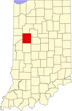 | |
| Towns | ||
| Townships | ||
| CDPs | ||
| Other communities | ||
| Ghost towns | ||
| Footnotes | ‡This populated place also has portions in an adjacent county or counties | |